
Portland Downtown Heliport, is a public heliport located in the Old Town Chinatown neighborhood in the Northwest section of the city of Portland, Multnomah County, Oregon, USA. It occupies the roof of a 1989 parking garage located at the intersection of NW Naito Parkway and NW Davis Street, not far from the Steel Bridge over the Willamette River.

Oxbow Dam is a hydroelectric run-of-the-river rockfill dam on the Snake River on the Idaho-Oregon border, in Hells Canyon. It is part of the Hells Canyon Project that also includes Hells Canyon Dam and Brownlee Dam, built and operated by Idaho Power Company.

McNary ARNG Field Heliport, is a military heliport located two miles (3 km) southeast of the city of Salem in Marion County, Oregon, USA. The heliport is located on the north east corner of Salem Municipal Airport. The heliport serves as the primary base of activity for the Oregon National Guard Army Aviation Support Facility.
Camp Rilea Heliport, is a military heliport located three miles (4.8 km) south of the city of Warrenton in Clatsop County, Oregon, USA.
Columbia Aviation Heliport is a private heliport located one mile northwest of Aurora in Marion County, Oregon, USA. Heliport is located adjacent to the Wes Lematta Field at Aurora State Airport on its east side approximately mid-field.
Columbia Helicopters Heliport is a private heliport located 2 miles northwest of Aurora in Marion County, Oregon, USA. The heliport is located at the northeast corner of Wes Lematta Field at Aurora State Airport and adjacent to the headquarters of Columbia Helicopters, Inc.
Sacred Heart Medical Center Heliport is a private heliport located at the Sacred Heart Medical Center near the University of Oregon campus in Eugene, Lane County, Oregon, United States.
Lake District Hospital Heliport is a private heliport located north of Lakeview in Lake County, Oregon, United States.

Providence Newberg Medical Center Heliport is a private heliport located in Newberg in Yamhill County, Oregon, United States. It was built in 2006 as a part of the Providence Newberg Medical Center. The heliport at the former Newberg Community Hospital, Newberg Community Hospital Heliport also moved when the hospital moved to its new location.

Emanuel Hospital Heliport is a private heliport located north of Portland in Multnomah County, Oregon, United States.

Oregon Health & Science University Heliport is a private heliport located in Portland in Multnomah County, Oregon, United States at Oregon Health & Science University.
Roberts Army Heliport is a U.S. Army heliport at Camp Roberts in extreme southern Monterey County, California, United States. It is located just off U.S. Route 101, four nautical miles northwest of the central business district of San Miguel, about halfway between it and the tiny community of Bradley in southern Monterey County. Roberts AHP has one helipad designated H1 with a 2,740 x 100 ft asphalt surface.
Willamette Falls Community Hospital Heliport is a private heliport located north of Oregon City in Clackamas County, Oregon, United States.

Varnell Heliport is a heliport located in unincorporated Galveston County, Texas, United States. The airport is located south of League City, east of Alvin, and northwest of Santa Fe.
Southampton Heliport is a heliport in the village of Southampton, New York.
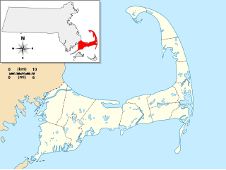
Camp Edwards Heliport is a private use heliport located at Camp Edwards, a U.S. Army facility in Barnstable County, Massachusetts, United States. The airport is located three nautical miles (6 km) north of the central business district of Bourne, Massachusetts. It is owned by the Massachusetts Army National Guard.
Lowe Army Heliport is a military heliport serving Fort Rucker in Dale County, Alabama, United States. Owned by the United States Army, it is located 8 nautical miles (15 km) southwest of the city of Ozark. World's busiest heliport launching over 100 flights daily.
Ferris Red Oak Muni Heliport is a city-owned public heliport in Ellis County, Texas, United States, serving the cities of Ferris, Texas and Red Oak, Texas. The heliport has no IATA or ICAO designation. The facility is alternately known as the Ferris Red Oak Municipal Heliport.
Dallas CBD Vertiport is a city-owned public heliport/vertiport in the city of Dallas, Dallas County, Texas, United States. The facility is located at the south end of the Kay Bailey Hutchison Convention Center in the Dallas Central Business District, and is claimed to be the world's largest elevated heliport/vertiport.
DeSoto Heliport is a city-owned public heliport in DeSoto, Dallas County, Texas, United States, located approximately 3 nautical miles (5.6 km) north of the central business district. The heliport has no IATA or ICAO designation.

