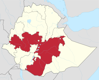
Oromia is a regional state in Ethiopia and the homeland of the Oromo people. Under Article 49 of Ethiopian Constitution, the capital of Oromia is Addis Ababa, also called Finfinne. The provision of the article maintains special interest of Oromia by utilizing social services and natural resources of Addis Ababa.

Arsi is a zone in Oromia Region of Ethiopia, named after a clan of the Oromo, who inhabit in the area.
Goba is a town and separate woreda located in the Bale Zone of the Oromia Region, Ethiopia approximately 446 km southeast of Addis Ababa, this city has a latitude and longitude of 7°0′N39°59′E and an elevation of 2,743 meters above sea level.
Bishoftu is a town in central Ethiopia. Located in the East Shewa Zone of the Oromia Region, it sits at an elevation of 1,920 metres (6,300 ft). It was formerly known as Debre Zeyit. However, since the late 1990s, it has been officially known by the Oromo name, Bishoftu from bishaanooftuu, which was its name until 1955. The town serves as the primary airbase of the Ethiopian Air Force.

Asella is a town in central Ethiopia. Located in the Arsi Zone of the Oromia Region 126 km (78 mi) south from Addis Ababa, this town has a latitude and longitude of 7°57′N39°7′E, with an elevation of 2,430 meters. Asella hosts an Asella Airport. Asalla was the capital of Arsi Province until that province was demoted to a Zone of Oromia with the adoption of the 1995 Constitution. It retains some administrative functions as the seat of the present Arsi Zone.
Jeju is a woreda in Oromia Region, Ethiopia. Part of the Arsi Zone, Jeju is bordered by Dodotana Sire to the west, the Misraq Shewa Zone to the north, Merti to the east, and Sude to the south. Its administrative centre is Arboye, located 168 kilometres southeast of Addis Ababa. Other towns in this woreda include Bolo.
Arboye is a town in eastern Ethiopia and the administrative centre of the Jeju woreda. Located in the Arsi Zone of the Oromia Region, 168 kilometers southeast of Addis Ababa on the road between Adama and Dire Dawa, this town has a latitude and longitude of 8°36′N40°13′E.

Welkait is a woreda in Western Zone, Tigray Region. This woreda is bordered to the north by Humera and to the south by Tsegede. It is bordered on the east by the North West Zone; the woredas of Tahtay Adiyabo and Asgede Tsimbla lie to the north-east, on the other side of the Tekezé River, and Tselemti to the east. The administrative center of Welkait is Addi Remets; other towns in the woreda include Mai'gaba and Awura.
Erer is a woreda in Somali Region, Ethiopia. Part of the Shinile Zone, Erer is bordered on the south by Dire Dawa and Oromia Region, on the southwest by Afdem, on the northwest by the Afar Region, and on the east by Shinile.
Shinile is a woreda in Somali Region, Ethiopia. Part of the Sitti Zone, Shinile is bordered on the south by Dire Dawa, on the west by Erer, on the north by the Afar Region, on the east by Ayesha, and on the southeast by Dembel and Jijiga Zone. Towns in Shinile include Adigale, Harewa, Milo, and Shinile; villages include Jaldessa, Marmaarsa, and Toome.
Cheliya is one of the Aanaas in the Oromia of Ethiopia. Part of the West Shewa Zone, Cheliya is bordered on the south by Nono and Dano, on the southwest by the Gibe River which separates it from the Jimma Zone, on the west by Bako Tibe, on the northwest by the Guder River which separates it from the Horo Gudru Welega Zone, on the north by Ginde Beret, on the northeast by Jeldu, on the east by Ambo, and on the southeast by Tikur. The administrative center of this Aanaa is Gedo; other towns in Cheliya include Babiche, Ejaji, and Hamus Gebeya. Midakegn woreda was separated form Cheliya.
Bako Tibe is one of the Aanaas, or districts, in the Oromia region of Ethiopia. Part of the West Shewa Zone, Bako Tibe is bordered on the south and west by the East Welega Zone, on the north by Horo Gudru Welega Zone, and on the east by Cheliya. The administrative center of this woreda is Bako; other towns in Bako Tibe include Tibe and Shoboka.
Mieso is a woreda in Oromia Region, Ethiopia. Part of the West Hararghe Zone, Mieso is bordered on the south by Guba Koricha, on the west by the Afar Region, on the north by the Somali Region, on the east by Doba and on the southeast by Chiro. The administrative center for this woreda is Mieso; other towns in Mieso include Asebot, Kora, Bordode and Gololcha.
Akaki is a woreda or district in Oromia Region, Ethiopia. Part of the Oromia Special Zone Surrounding Finfinne, Akaki is bordered on the southwest by the Southwest Shewa Zone, on the west by Sebeta Hawas, on the northwest by Addis Ababa, on the north by the Bereh, and on the east by East Shewa Zone. The administrative center of this woreda is Dukem.
Naannawa Shashamane is a woreda in Oromia Region, Ethiopia. It is named after the town of Shashamene what was separated from this woreda. Part of the West Arsi Zone located in the Great Rift Valley, Shashamene is bordered on the south by the Southern Nations, Nationalities and Peoples Region, on the west by Shala, on the north by Arsi Negele, on the east by the Kore, and on the southeast by Kofele. The largest town in Shashamene is Kuyera.
Dodota is one of the woredas in the Oromia Region of Ethiopia. Part of the Arsi Zone it is located in the Great Rift Valley. It is part of the former Dodotana Sire woreda, which was divided for Dodota and Sire woredas. Dodotana Sire is bordered on the south by Tena, on the southwest by Hitosa, on the north by the Misraq Shewa Zone, on the east by Jeju, and on the southeast by Sude. The administrative center for the woreda is Dera; other towns include Awash Melkasa.
Robe is one of the Aanaas in the Oromia Regional State of Ethiopia. It is named after the Robe River, 80 kilometers of which flows through the woreda. Part of the Arsi Zone, Robe is bordered on the south by the Shebelle River which separates it from the Bale Zone, on the southwest by Sherka, on the west by Tena, on the north by Sude, on the northeast by Amigna, and on the east by Seru. The administrative center of the woreda is Robe; other towns in Robe include Habe and Sedika.
Sendafa is a town and separate woreda in Oromia Region, Ethiopia. Its name is taken from the Oromo name for a kind of thick, jointed grass or reed which grows in swampy areas. Located in the Oromia Special Zone Surrounding Finfinne of the Oromia Region, Sendafa has a latitude and longitude of 9°09′N39°02′E with an elevation of 2514 meters above sea level. The town lies on the paved Addis Ababa - Adigrat highway, some 38 kilometers north of the capital.
Metehara is a town in central Ethiopia. Located in the East Shewa Zone of the Oromia Region, it has a latitude and longitude of 08°54′N39°55′E with an elevation of 947 meters above sea level.
Emdibir is a town south-west of Addis Ababa, in the central part of Ethiopia. Located in the Gurage Zone of the Southern Nations, Nationalities and Peoples' Region, this town has a latitude and longitude of 8°7′N37°56′E and an elevation between 2130 and 2164 meters above sea level. It is the administrative center of Cheha woreda.