
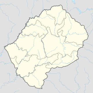
Lesotho is a mountainous, landlocked country located in Southern Africa. It is an enclave, surrounded by South Africa. The total length of the country's borders is 909 kilometres (565 mi). Lesotho covers an area of around 30,355 square kilometres (11,720 sq mi), of which a negligible percentage is covered with water.
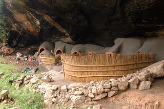
Berea is a district of Lesotho. In the west, Berea borders on the Free State Province of South Africa. Domestically, it borders on the following districts: Leribe District in the north, Thaba-Tseka District in southeast and Maseru District in the south. Teyateyaneng is the capital of the district. It is also home to the Kome Cave Dwellings. It is also the only district in Lesotho which is not named after its capital.

Mafeteng is a city in Lesotho, and the Camptown of the district of Mafeteng. It is located about 76 kilometres south of the country's capital, Maseru and has a population of approximately 61,000. The South African border town to Mafeteng is Wepener.

The Highveld is the portion of the South African inland plateau which has an altitude above roughly 1500 m, but below 2100 m, thus excluding the Lesotho mountain regions to the south-east of the Highveld. It is home to some of the country's most important commercial farming areas, as well as its largest concentration of metropolitan centres, especially the Gauteng conurbation, which accommodates one-third of South Africa's population.
Nsoko is a town in southern Eswatini about five kilometres (3.1 mi) from the border with South Africa. It lies about 65 kilometres (40 mi) north-east of Lavumisa and 45 kilometres (28 mi) south-east of Maloma. The town lies on the Ngwavuma river.
The God Help Me Pass, or Lekhalong-la-Molimo-Nthuse in seSotho, is a mountain pass in western Lesotho. It is the second mountain pass on the A3 road going into the central highlands. The road ascends steeply from the village of Setibing, and near the summit is the Basotho Pony Trekking Centre, which offers a variety of trekking expeditions. The Makhaleng River flows close by Setibing, and its valley forms the western approach to the pass. The higher Blue Mountain Pass, Lekhalong-la-Thaba-Putsoa, is a few kilometres further east, and the first mountain pass, Bushman's Pass, Lekhalong-la-Baroa, is about 10 km to the west, rising from the village of Nazareth.
Morija is a town in western Lesotho, located 35 kilometres south of the capital, Maseru. Morija is one of Lesotho’s most important historical and cultural sites, known as the Selibeng sa Thuto— the Well-Spring of Learning. It was the site of the first French Protestant mission in Lesotho, founded in 1833. The town also houses the Morija Museum and Archives, well known for supporting research and preserving valuable records and documents of Lesotho’s history.
Agarak is a village in the Aragatsotn Province of Armenia. It is located on Amberd River. The modern settlement was founded in 1919 by emigrants from Van and Bitlis.

Budyń is a village in the administrative district of Gmina Bukowiec, within Świecie County, Kuyavian-Pomeranian Voivodeship, in north-central Poland. It lies approximately 5 kilometres (3 mi) north-east of Bukowiec, 12 km (7 mi) north-west of Świecie, and 43 km (27 mi) north-east of Bydgoszcz.
Grabinka is a village in the administrative district of Gmina Warta, within Sieradz County, Łódź Voivodeship, in central Poland. It lies approximately 13 kilometres (8 mi) east of Warta, 14 km (9 mi) north of Sieradz, and 47 km (29 mi) west of the regional capital Łódź.
Pustkowa Góra is a village in the administrative district of Gmina Parzęczew, within Zgierz County, Łódź Voivodeship, in central Poland. It lies approximately 6 kilometres (4 mi) south-east of Parzęczew, 12 km (7 mi) north-west of Zgierz, and 20 km (12 mi) north-west of the regional capital Łódź.
Podlesie is a settlement in the administrative district of Gmina Wadowice Górne, within Mielec County, Subcarpathian Voivodeship, in south-eastern Poland. It lies approximately 3 kilometres (2 mi) north-east of Wadowice Górne, 9 km (6 mi) west of Mielec, and 57 km (35 mi) north-west of the regional capital Rzeszów.
Hłomcza is a village in the administrative district of Gmina Sanok, within Sanok County, Subcarpathian Voivodeship, in south-eastern Poland. It lies approximately 11 kilometres (7 mi) north-east of Sanok and 49 km (30 mi) south-east of the regional capital Rzeszów.

Razdolnaya or Suifen is a river in People's Republic of China and Russia.
Kuligowo is a village in the administrative district of Gmina Babimost, within Zielona Góra County, Lubusz Voivodeship, in western Poland. It lies approximately 2 kilometres (1 mi) south of Babimost and 30 km (19 mi) north-east of Zielona Góra.
Stara Huta is a village in the administrative district of Gmina Przywidz, within Gdańsk County, Pomeranian Voivodeship, in northern Poland. It lies approximately 4 kilometres (2 mi) west of Przywidz, 25 km (16 mi) west of Pruszcz Gdański, and 30 km (19 mi) south-west of the regional capital Gdańsk.
Dębina is a settlement in the administrative district of Gmina Dziemiany, within Kościerzyna County, Pomeranian Voivodeship, in northern Poland. It lies approximately 3 kilometres (2 mi) south-east of Dziemiany, 18 km (11 mi) south-west of Kościerzyna, and 68 km (42 mi) south-west of the regional capital Gdańsk.
Sądów is a village in the administrative district of Gmina Dolice, within Stargard County, West Pomeranian Voivodeship, in north-western Poland. It lies approximately 7 kilometres (4 mi) south-east of Dolice, 26 km (16 mi) south-east of Stargard, and 55 km (34 mi) south-east of the regional capital Szczecin.
The Rural Municipality of Daly is a former rural municipality (RM) in the Canadian province of Manitoba. It was originally incorporated as a rural municipality on December 22, 1883. It ceased on January 1, 2015 as a result of its provincially mandated amalgamation with the Town of Rivers to form the Riverdale Municipality.


