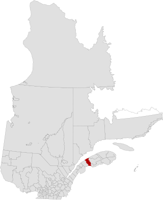
La Mitis is a regional county municipality in the Bas-Saint-Laurent region in eastern Quebec, Canada on the Gaspé peninsula. It is named for the Mitis River which has its source in the region and flows through the central part of the region before emptying into the Saint Lawrence River.

Vaudreuil-Soulanges is a regional county municipality in Quebec, Canada. It is located on a triangular peninsula in the western Montérégie region of Quebec, formed by the confluence of the Ottawa River to the north, and the St. Lawrence River to the south. Ontario is located west of here.

Boisbriand is an off-island suburb of Montreal, at the entrance of the Lower-Laurentides in southwestern Quebec, Canada, on the north shore of the Rivière des Mille Îles in the Thérèse-De Blainville Regional County Municipality.

Sainte-Thérèse is an off-island suburb northwest of Montreal, in southwestern Quebec, Canada, in the Thérèse-De Blainville Regional County Municipality.

The Matapedia Valley was formed by the Chic-Choc Mountains of eastern Québec. Its name is derived from the river that traverses the valley, as well as the lake that lies in its center. It is situated in the southwest of the Gaspé Peninsula and stretches 375 km (233 mi).

Saint-Joseph-du-Lac is a municipality in the Laurentides region of Quebec, Canada, part of the Deux-Montagnes Regional County Municipality.

La Visitation-de-l'Île-Dupas is a municipality in the Lanaudière region of Quebec, Canada, part of the D'Autray Regional County Municipality. Its territory is located on several of the Sorel Islands in the Saint Lawrence River where it flows into Lac Saint-Pierre. The largest of these islands is Dupas Island, also known as Isle du Pads, Île d'Angoulème, and Île du Richelieu at various times in the past.

Saint-Joseph-de-Lepage is a parish municipality in La Mitis Regional County Municipality in the Bas-Saint-Laurent region of Quebec, Canada.

Les Éboulements is a municipality in the Capitale-Nationale region of Quebec, Canada.

Lac-Alfred is an unorganized territory in the Bas-Saint-Laurent region of Quebec, Canada.

The seignory of Lac-Matapédia is a forest land located on the north shore of Lake Matapédia in the Matapédia Valley in the unorganized territory of Lac-Matapédia, in Amqui, and in Sayabec, in the La Matapédia Regional County Municipality, in administrative region of Bas-Saint-Laurent, Quebec, Canada. The territory is under a "forest supply and management contract" with the Ministry of Natural Resources and Wildlife (Quebec). It is also the regional Park of Lac-Matapédia.
The Lessard Seignory was a seignory during the French colonisation of New France. It was located in the present-day Rimouski-Neigette Regional County Municipality in Bas-Saint-Laurent.
The seignory of Bic was a seignory during the French colonisation of New France. It was located in present Rimouski-Neigette Regional County Municipality in Bas-Saint-Laurent.
The Mitis Seignory is a forest and wildlife territory located in La Mitis Regional County Municipality in eastern Quebec. It was a seignory during the French colonisation of New France.
The Madawaska Seignory was a seignory during the French colonisation of New France. It was located in present-day Témiscouata Regional County Municipality in Bas-Saint-Laurent.
The Rimouski Seignory was a seignory during the French colonisation of New France. It was located in the present-day Rimouski-Neigette Regional County Municipality in Bas-Saint-Laurent, Quebec.

The Seigneurie of Batiscan was located on, and included 1/2 lieue of frontage along, the north shore of the St. Lawrence River in the province of Quebec, Canada. It was 20 lieues deep. Granted in 1639 to the Jesuits, colonization of the manor began in 1666, after an initial allotments were added to the census in 1665.) The northern boundary of the seigneurie was past the source of the Saint-Maurice River. It was the deepest in the seigneurial system of New France. The seigneurie of Batiscan became the most populous governed area of the Three Rivers by the end of the 17th Century.
École Polyvalente Deux-Montagnes (PDM) is a Francophone secondary school in Deux-Montagnes, Quebec, Canada. It is a part of the Commission scolaire de la Seigneurie-des-Mille-Îles (CSSMI).

The lordship of Lac-des-Deux-Montagnes was a seigneury in New France. It was located in the current regional county municipality of Deux-Montagnes Regional County Municipality in the administrative region of Laurentides in Quebec (Canada).


