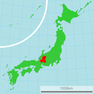
Ōgaki is a city located in Gifu, Japan. As of 31 October 2018, the city had an estimated population of 161,539, and a population density of 380 persons per km2 in 65,931 households. The total area of the city was 206.57 square kilometres (79.76 sq mi). Ōgaki was the final destination for the haiku poet Matsuo Bashō on one of his long journeys as recounted in his book Oku no Hosomichi. Every November the city holds a Bashō Festival.

Tarui is a town located in Fuwa District, Gifu Prefecture, Japan. As of 1 December 2018, the town had an estimated population of 27,439 and a population density of 480 persons per km2, in 10,525 households. The total area of the town was 57.09 square kilometres (22.04 sq mi).

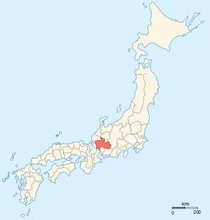
Sekigahara is a town located in Fuwa District, Gifu Prefecture, Japan. As of 1 December 2018, the town had an estimated population of 7,109 and a population density of 140 persons per km2, in 2,725 households. The total area of the town was 49.28 square kilometres (19.03 sq mi).

Ibigawa is a town located in Ibi District, Gifu Prefecture, Japan. As of 1 December 2018, the town had an estimated population of 21,319 in 8,015 households and a population density of 27 persons per km2, in 8,032 households. The total area of the town was 803.44 square kilometres (310.21 sq mi).

Ōno is a town located in Ibi District, Gifu Prefecture, Japan. As of 1 December 2018, the town had an estimated population of 23,111 in 7906 households and a population density of 680 persons per km2.The total area of the town was 803.44 square kilometres (310.21 sq mi).

Ikeda is a town located in Ibi District, Gifu Prefecture, Japan. As of 1 December 2018, the town had an estimated population of 24,034 in 8291 households and a population density of 620 persons per km2. The total area of the town was 38.80 square kilometres (14.98 sq mi).
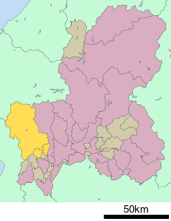
Ibi District is a district located in Gifu Prefecture, Japan. As of July 2011, the district has an estimated population of 72,109. The total area is 876.65 km².

Tōnō (東濃) is the southeastern portion of Gifu Prefecture in the Chūbu region of Japan. The Tōnō region received its name as a combination of the kanji for "east" (東) and "Mino" (美濃). The borders of this region are not officially set, but it generally consists of the following cities: Tajimi, Toki, Mizunami, Ena and Nakatsugawa. Occasionally, Kani, usually part of the Chūnō region, is also included as being part of Tōnō.

The Nagara River has its source in the city of Gujō, Gifu Prefecture, and its mouth in the city of Kuwana, Mie Prefecture, Japan. Along with the Kiso River and Ibi River, the Nagara River is one of the Kiso Three Rivers of the Nōbi Plain. Previously, the river was named Sunomata River. With a length of 166 km (103 mi), it drains an area of 1,985 square kilometres (766 sq mi) in the Chūbu region and empties into Ise Bay. The government of Japan classifies it as a Class 1 river.

The Ibi River is a tributary of the Kiso River located in Gifu and Mie Prefectures in Japan. Along with the Nagara and Kiso rivers, the Ibi is the third of the Kiso Three Rivers of the Nōbi Plain. It is one of Japan's first-class rivers. The former Tōkaidō post station of Kuwana-juku was located on the western banks of this river during the Edo period.

The Yōrō Line is a railway line of a Japanese private railway operator Yōrō Railway. The line traverses the northeastern side of the Yōrō Mountains and connects Kuwana Station in Kuwana, Mie Prefecture and Ibi Station in Ibigawa, Gifu Prefecture.

The Seinō Railway is a freight only railway company in Ōgaki, Gifu, Japan. The company was founded in 1927. Its line mainly transports limestone. The company is not related to Seinō Transportation (西濃運輸), a transportation company with similar name, also based in Ōgaki. The company was reported as being dissolved in 2013.

The Nōbi Plain is a large plain in Japan that stretches from the Mino area of southwest Gifu Prefecture to the Owari area of northwest Aichi Prefecture, covering an area of approximately 1,800 square kilometres (695 sq mi). It is an alluvial plain created by the Kiso Three Rivers and has very fertile soil. It is bordered on the west by the Ibuki and Yōrō mountain ranges, and to the east by the Owari Hills. Its northern border is marked by the Ryōhaku Mountains and the south by Ise Bay.
Gifu (岐阜) is the southcentral portion of Gifu Prefecture in the Chūbu region of Japan. It shares its name with the prefecture and the capital city of Gifu. The borders of this region are not officially set, but it generally consists of the following cities and towns: Gifu, Kakamigahara, Hashima, Mizuho, Motosu, Yamagata, Kasamatsu, Ginan and Kitagata.

The Ibuki Mountains are a mountain range straddling the border between Gifu and Shiga prefectures in Japan. After lowering and nearly disappearing in Shiga Prefecture, the range continues as the Suzuka Mountains. During the winter, the winds from the Ibuki Mountains are a cause of much of the snowfall on the Nōbi Plain covering Gifu and Aichi prefectures.
Chūnō (中濃) is the central portion of Gifu Prefecture in the Chūbu region of Japan. Before Gifu became a prefecture, the area was part of Mino Province. The Chūnō region received its name as a combination of the kanji for "middle" (中) and "Mino" (美濃). The borders of this region are not officially set, but it generally consists of thirteen municipalities. There are five cities in addition to the towns and village in the Kamo and Kani (Mitake) districts also fall into the Chūnō region. Occasionally, Gujō is separated from the Chūnō region and is said to be part of the Hokunō region.

Mino-Akasaka Station is a train station in the city of Ōgaki, Gifu Prefecture, Japan operated by the Central Japan Railway Company. It is also a freight terminal for the Japan Freight Railway Company.
The Mino dialect is a Japanese dialect spoken in the southern area, made up of the former area known as Mino Province, of Gifu Prefecture, Japan. It is also referred to as the Tōnō dialect by residents of the Tōnō region of the prefecture, which is the eastern part of the former province. It is sometimes also referred to as the Gifu dialect, but that can sometimes include Hida dialect, which is in the northern part of Gifu Prefecture.

Mount Ikeda is a mountain located in the towns of Ikeda and Ibigawa, in Ibi District, Gifu Prefecture, Japan.