Related Research Articles

Yakima is a city in, and the county seat of, Yakima County, Washington, United States, and the state's 11th most populous city. As of the 2020 census, the city had a total population of 96,968 and a metropolitan population of 256,728. The unincorporated suburban areas of West Valley and Terrace Heights are considered a part of greater Yakima.

Interstate 82 (I-82) is an Interstate Highway in the Pacific Northwest region of the United States that travels through parts of Washington and Oregon. It runs 144 miles (232 km) from its northwestern terminus at I-90 in Ellensburg, Washington, to its southeastern terminus at I-84 in Hermiston, Oregon. The highway passes through Yakima and the Tri-Cities, and is also part of the link between Seattle and Salt Lake City, Utah. I-82 travels concurrently with U.S. Route 97 (US 97) between Ellensburg and Union Gap; US 12 from Yakima to the Tri-Cities; and US 395 from Kennewick to Umatilla, Oregon.

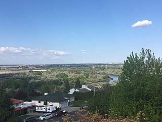
Selah is a city in Yakima County, Washington, United States. It is north of Yakima and part of its metropolitan area. The city's population was 8,153 at the 2020 census.

Union Gap is a city in Yakima County, Washington, United States. As of the 2020 census, the city population was 6,568. Union Gap has become the retail hub for the entire Yakima Valley as a result of Valley Mall and other thriving businesses being located here. Part of the city is part of the Yakama Nation.

The Delaware Water Gap is a water gap on the border of the U.S. states of New Jersey and Pennsylvania where the Delaware River cuts through a large ridge of the Appalachian Mountains.

The Yakama are a Native American tribe with nearly 10,851 members, based primarily in eastern Washington state.

The French Broad River is a river in the U.S. states of North Carolina and Tennessee. It flows 218 miles (351 km) from near the town of Rosman in Transylvania County, North Carolina, into Tennessee, where its confluence with the Holston River at Knoxville forms the beginning of the Tennessee River. The river flows through the counties of Transylvania, Buncombe, Henderson, and Madison in North Carolina, and Cocke, Jefferson, Sevier, and Knox in Tennessee. It drains large portions of the Pisgah National Forest and the Cherokee National Forest.

Swatara Creek is a 72-mile-long (116 km) tributary of the Susquehanna River in east-central Pennsylvania in the United States. It rises in the Appalachian Mountains in central Schuylkill County and passes through northwest Lebanon County before draining into the Susquehanna at Middletown in Dauphin County.

Manastash Ridge is a long anticline mountain ridge located in central Washington state in the United States. Manastash Ridge runs mostly west-to-east in Kittitas and Yakima counties, for approximately 50 miles. The ridge is part of the Yakima Fold Belt of east-tending long ridges formed by the folding of Miocene Columbia River basalt flows.

The Palouse to Cascades State Park Trail, formerly known as the John Wayne Pioneer Trail and the Iron Horse Trail, is a rail trail that spans most of the U.S. state of Washington. It follows the former railway roadbed of the Chicago, Milwaukee, St. Paul & Pacific Railroad for 300 miles (480 km) across two-thirds of the state, from the western slopes of the Cascade Mountains to the Idaho border.

State Route 821 (SR 821) is a state highway in central Washington state. It runs for 25 miles (40 km) through the Yakima Canyon, following the meandering Yakima River between Selah and Ellensburg. Both ends of the highway are at interchanges with Interstate 82 (I-82) and U.S. Route 97 (US 97).

State Route 823 (SR 823) is a state highway in Yakima County, Washington, United States. It runs for 5.6 miles (9.0 km) from an interchange with U.S. Route 12 (US 12) and through the city of Selah to a junction with SR 821. A portion of the highway runs in the median of Interstate 82 (I-82), its parent route, as it crosses the Naches River.

Snoqualmie Pass is a mountain pass that carries Interstate 90 (I-90) through the Cascade Range in the U.S. state of Washington. The pass summit is at an elevation of 3,015 feet (919 m), on the county line between Kittitas County and King County.

Umtanum Ridge Water Gap is a geologic feature in Washington state in the United States. It includes the Yakima Canyon, and is located between the cities of Ellensburg and Yakima in central Washington. Washington State Route 821 was once the main route between Ellensburg and Yakima. The old highway still runs close to the river through the canyon, with Interstate 82 currently carrying most traffic between Ellensburg and Yakima on large bridges nearby.

U.S. Route 97 in the U.S. state of Washington is a 322-mile (518 km) route which traverses from the Oregon state line at the northern end of the Sam Hill Memorial Bridge in Maryhill, north to the Canada–US border in Okanogan County near Oroville. The highway serves major cities such as Goldendale, Yakima, Ellensburg and Wenatchee before continuing towards the Alaska Highway at the Yukon border as British Columbia Highway 97. Along the length of the roadway, US 97 is concurrent with State Route 14 in Maryhill, Interstate 82 (I-82) and US 12 between Union Gap and Ellensburg, I-90 briefly in Ellensburg, US 2 between Peshastin and rural Douglas County and SR 20 near Omak. An alternate route connects the highway with Chelan.

The Yakima Training Center (YTC) is a United States Army training center, used for maneuver training, Land Warrior system testing and as a live fire exercise area. It is located in the south central portion of the U.S. state of Washington, bounded on the west by Interstate 82, on the south by the city of Yakima, on the north by the city of Ellensburg and Interstate 90, and on the east by the Columbia River. It is a part of Joint Base Lewis-McChord. It comprises 327,000 acres of land, most of which consists of shrub-steppe, making it one of the largest areas of shrub-steppe habitat remaining in Washington state. The terrain is undulating and dominated by three east-west parallel ridges, the Saddle Mountains, Manastash Ridge, and Umtanum Ridge anticlines, which are part of the Yakima Fold Belt near the western edge of the Columbia River Plateau. Vegetation consists of sagebrush, bitterbrush, and bunch grass. Vagabond Army Airfield and Selah Airstrip are located on the Yakima Training Center. The training center is also used by the Japan Ground Self-Defense Force for exercises.

Ahtanum Ridge is a long anticline mountain ridge in Yakima County in the U.S. state of Washington. It is located just south of the city of Yakima, and much of its length is at the northern edge of the Yakama Indian Reservation. Its name comes from the Sahaptin toponym [átanɨm].

Umtanum Ridge is a long anticline mountain ridge in Yakima County and Kittitas County in the U.S. state of Washington. It runs for approximately 55 miles east-southeast from the Cascade Range, through the Yakima Training Center to the edge of the Columbia River at Priest Rapids Dam and Hanford Reach. The eastern end of Umtanum Ridge enters Hanford Reach National Monument and the Hanford Site. Umtanum Ridge is paralleled on the north by Manastash Ridge and on the south by Yakima Ridge. The Yakima River cuts through the ridge at the Umtanum Ridge Water Gap.
Yakima Ridge is a long anticline mountain ridge in Yakima County and Benton County in the U.S. state of Washington. From its western end just north of the city of Yakima, the ridge runs east-southeast through the Yakima Training Center to its eastern end at Hanford Reach National Monument and the Hanford Site. Yakima Ridge is paralleled on the north by Umtanum Ridge and on the south by the Rattlesnake Hills. Moxee Valley and Black Rock Valley lie south of Yakima Ridge.
The Yakima River Delta is an area of land in Richland, Washington where the Yakima River enters the Columbia River at River Mile 335. It hosts several protected areas and is crossed by State Route 240. This area is mostly floodplain with riparian-type growth, including non-native species such as Russian olive. Amon Creek enters the Yakima River in this area.
References
- ↑ Campbell, Newell P. (1975), A Geologic Road Log Over Chinook, White Pass and Ellensburg to Yakima Highways (PDF), Washington Department of Natural Resources, p. 66, Information circular 54
- ↑ Water System Plan, City of Selah, February 2015. Chapter one: Description of Water System, page 1-4.
- ↑ Yakima Greenway Trail - Naches River Bridge, Bridgehunter
- ↑ David Badders (August 10, 2012), "Follow in William O. Douglas' footsteps from Yakima to the wilderness", The Oregonian