Selakano (Greek: Σελάκανο) is a forested valley and a hamlet in the municipality of Ierapetra on the island of Crete. Selakano forms one of the most important ecosystems on Crete. The forest core of wild pine is also important on the Mediterranean level. It is located in the northwestern territories of Ierapetra in the southeastern part of the Dikti massif, surrounded by the four highest peaks (Lazaros 2085 m, Spathi 2148 m, Afendis Christos 2141 m, Psari Madara 2090 m). In the east, there is a panoramic view of the Libyan Sea, at a distance of 15km.
Greek is an independent branch of the Indo-European family of languages, native to Greece, Cyprus and other parts of the Eastern Mediterranean and the Black Sea. It has the longest documented history of any living Indo-European language, spanning more than 3000 years of written records. Its writing system has been the Greek alphabet for the major part of its history; other systems, such as Linear B and the Cypriot syllabary, were used previously. The alphabet arose from the Phoenician script and was in turn the basis of the Latin, Cyrillic, Armenian, Coptic, Gothic, and many other writing systems.
A hamlet is a small human settlement. In different jurisdictions and geographies, hamlets may be the size of a town, village or parish, be considered a smaller settlement or subdivision or satellite entity to a larger settlement. The word and concept of a hamlet have roots in the Anglo-Norman settlement of England, where the old French hamlet came to apply to small human settlements. In British geography, a hamlet is considered smaller than a village and distinctly without a church.
Ierapetra is a town and municipality on the south coast of Crete.
In the forest Pinus brutia is a prevalent drought-tolerant species that can withstand six-month droughts and grow in various rocks and soils. There are also kermes oaks (Quercus coccifera), planes (Platanus orientalis), Cretan maples (Acer sempervirens), cypresses (Cupressus sempervirens) and several other plant species. In the basin, where the settlements of Selakano and Mathokastana are located, there are many walnut and pear trees, vineyards and, patches of fields where vegetables are cultivated.
Pinus brutia, the Turkish pine, is a pine native to the eastern Mediterranean region. The bulk of its range is in Turkey, but it also extends to southeastern-most Bulgaria, the East Aegean Islands of Aegean Sea, Crete, the Crimea, Iran, Georgia, Azerbaijan, northern Iraq, western Syria, Israel, north-west Jordan, Lebanon, and Cyprus. It generally occurs at low altitudes, mostly from sea level to 600 metres (2,000 ft), up to 1,200 metres (3,900 ft) in the south of its range.
Quercus coccifera, the kermes oak, is an oak tree in the Quercus section Cerris. It is native to the Mediterranean region and Northern African Maghreb, south to north from Morocco to France and west to east from Portugal to Cyprus and Turkey, crossing Spain, Italy, Libya, Balkans, and Greece, including Crete. The Kermes Oak was historically important as the food plant of the Kermes scale insect, from which a red dye called crimson was obtained. The etymology of the specific name coccifera is related to the production of red cochineal (crimson) dye and derived from Latin coccum which was from Greek κόκκος, the kermes insect. The Latin -fera means 'bearer'.
Platanus orientalis, the Old World sycamore, or Oriental plane, is a large, deciduous tree of the Platanaceae family, growing to 30 m (98 ft) or more, and known for its longevity and spreading crown.
The forest is the nesting and hunting ground of many predatory birds like the hawk. It is the most productive apiculture spot in Crete, while in the past wood and resin were harvested.
A geographic coordinate system is a coordinate system that enables every location on Earth to be specified by a set of numbers, letters or symbols. The coordinates are often chosen such that one of the numbers represents a vertical position and two or three of the numbers represent a horizontal position; alternatively, a geographic position may be expressed in a combined three-dimensional Cartesian vector. A common choice of coordinates is latitude, longitude and elevation. To specify a location on a plane requires a map projection.
This page is based on this Wikipedia article Text is available under the CC BY-SA 4.0 license; additional terms may apply. Images, videos and audio are available under their respective licenses.
Related Research Articles
Crete is the largest and most populous of the Greek islands, the 88th largest island in the world and the fifth largest island in the Mediterranean Sea, after Sicily, Sardinia, Cyprus, and Corsica. Crete and a number of surrounding islands and islets constitute the region of Crete, one of the 13 top-level administrative units of Greece. The capital and the largest city is Heraklion. As of 2011, the region had a population of 623,065.
In botany, an evergreen is a plant that has leaves throughout the year that are always green. This is true even if the plant retains its foliage only in warm climates, and contrasts with deciduous plants, which completely lose their foliage during the winter or dry season. There are many different kinds of evergreen plants, both trees and shrubs. Evergreens include:
Lasithi is the easternmost regional unit on the island of Crete, to the east of Heraklion. Its capital is Agios Nikolaos, the other major towns being Ierapetra, Sitia and Neapoli. The mountains include the Dikti in the west and the Thrypti in the east. The Sea of Crete lies to the north and the Libyan Sea to the south.
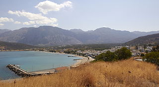
Myrtos is a coastal village in the west of the municipality of Ierapetra, in the Regional Unit of Lasithi on the Greek island of Crete. It is located 50 km (31 mi) from Agios Nikolaos and 15 km (9.3 mi) from Ierapetra, on the road to Viannos. A little to the west of the village is the iconic conical Kolektos mountain. Myrtos is situated on the Libyan Sea. The patron saint of the village is Saint Anthony.
The population of the village in 2010 was approximately 600 people.
Episkopi Ierapetras is a village on the Greek island of Crete. Episkopi belongs to the municipality of Ierapetra in the prefecture of Lasithi. It lies north of Ierapetra in the middle of the narrowest part of the island. The village has approximately one thousand inhabitants.
Vasiliki is the name of a village in the municipality of Ierapetra, in the prefecture of Lasithi, on Crete, and the name of the nearby Minoan archeological site. The site took its name from the village.
Gra Lygia is located approximately 4 km west of Ierapetra center. Its residents are called "GraLighiotes". They are occupied mainly in the agriculture sector; this is the main source of income for the residents and their income per capita is one of the highest in the region. The village is surrounded by greenhouses which demonstrates that the agriculture sector is modernized. There are many firms in related fields such as agriculture companies that co-operate with multinationals.
Males is a historic village in the municipality of Ierapetra in Lasithi prefecture on Crete. It is situated 25 kilometers north-west of Ierapetra, 40 from Agios Nikolaos and 12 kilometers away from the sea. Together with nearby hamlets Hristos and Metaxohori Males until recently formed the Nea Mala municipality. It is built 550 meters above sea level, south east of Dikti mountain, in an area rich in vegetation. It is built where the ancient city of Mala was.
Ano Simi is a village on Crete in the prefecture of Lasithi. It is part of Ierapetra municipality and borders Viannos municipality. It lies about 900 meters above sea level, south of Mount Dikti in what is probably the most wooded area of Crete. It is about 1 kilometer from Kato Simi, and 32 kilometers from Ierapetra.
Greece is a country in Southern Europe, bordered to the north by Albania, North Macedonia and Bulgaria; to the east by Turkey, and is surrounded to the east by the Aegean Sea, to the south by the Cretan and the Libyan Seas, and to the west by the Ionian Sea which separates Greece from Italy.
Kato Symi is a small historic village of Crete, in Heraklion regional unit, 31 km (19 mi) from Ierapetra and 74 km (46 mi) from Heraklion city. Today it belongs to Viannos municipality and borders the Ierapetra municipality. It lies about 780 m (2,560 ft) above sea level, south of Mount Dikti in a verdant mountainous area, which is probably the most wooded of Crete. Near the village, at an altitude of 1,200 m (3,900 ft), lies the ancient sanctuary of Hermes and Aphrodite. It is dated from the middle Minoan period and had been used for worship for more than 1,000 years. Kato Simi has been destroyed three times, by Arabs, Turks and finally by the German army in World War II, when it was the center of resistance of the Viannos–Ierapetra area against the Nazi occupying forces.
The Sarakina Gorge is a canyon in the southeastern part of Crete, Greece. It is located about 15 km west of Ierapetra and a few kilometres upcountry of Myrtos, near the small village of Mithi.
Meseleroi is a village in the east of the Greek island of Crete, in the regional unit of Lasithi. It is located 9km north of Ierapetra, and lies within its administrative limits. The village is 360 meters above sea level.
Stavrochori is a historic village of eastern Crete. It belonged to the former province of Sitia and later to the former Makry Gialos municipality. Today it is part of Ierapetra municipality. It is located in a wooded valley, 29 kilometers north east from Ierapetra and 35 kilometers southwest from Sitia. Once it was the most populous village of the region and the administrative center of the surrounding settlements. Since the last 30 years, the majority of its population has moved to the seaside settlement of Koutsouras, 7 kilometers to the south. Stavrochori is a traditional village with many sights. It is also the birthplace of Ioannis Papachatzakis or " Stravogiannios ", a violinist, who lived and died in Ierapetra. He was one of the most important Cretan traditional organ players of the last century.
Agios Stefanos is a village within the Lasithi prefecture in eastern Crete. It belonged to the former province of Siteia until that was abolished in 2006. Between 1997 and 2010, it was part of the former Makry Gialos municipality. Today, it is part of Ierapetra municipality. It is located 30 kilometers north-east of Ierapetra, 40 kilometers southwest of Sitia, and six kilometers east of Stavrohori. It can be approached through the famous forest of Pefkoseli. Its patron is Saint Stephen. Saint Stephen church, at the entrance of the village, is an ecclesiastical and historical monument of Crete. Since the last decade, the majority of the population has been moved to the village's seaside settlement of Makry Gialos, some six kilometers to the south. Makry Gialos is one of Crete's most important tourist resorts.
The Isthmus of Ierapetra is the most narrow part of Crete.
The beach of Agia Fotia is located 13 kilometers east of Ierapetra, in Crete. It was awarded the Blue Flag in 2006. The village is named after the church of Agia Fotini located here.
Pacheia Ammos is a village in the municipality of Ierapetra on the island of Crete in Greece. It is located on the north coast of the island, 15 km to the north of the city of Ierapetra, at the fork in the road that leads to Heraklion in the west and Sitia in the east.
Ha Gorge is a narrow gorge, at the Monasteraki Dakos, on the eastern part of the island of Crete in Greece. It is located in the west slope of Thrypti mountain range, and exits east
of Vasiliki village in the plain of Ierapetra. From this location scenic views overlook Pahia Amos and the bay. Being practically inaccessible to people, the gorge maintains a rich and diverse flora and fauna. Its depth is about 1,000 metres (3,300 ft) and the fissure is said to be one of the largest in the world. Late Minoan IIIC sites are in the area.