Related Research Articles
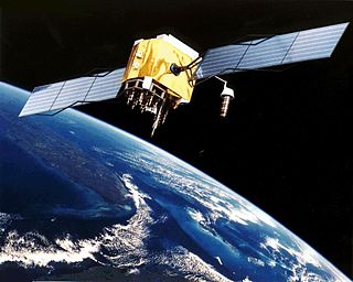
The Global Positioning System (GPS), originally Navstar GPS, is a satellite-based radio navigation system owned by the United States government and operated by the United States Space Force. It is one of the global navigation satellite systems (GNSS) that provides geolocation and time information to a GPS receiver anywhere on or near the Earth where there is an unobstructed line of sight to four or more GPS satellites. It does not require the user to transmit any data, and operates independently of any telephonic or Internet reception, though these technologies can enhance the usefulness of the GPS positioning information. It provides critical positioning capabilities to military, civil, and commercial users around the world. Although the United States government created, controls and maintains the GPS system, it is freely accessible to anyone with a GPS receiver.
Galileo is a global navigation satellite system (GNSS) that went live in 2016, created by the European Union through the European Space Agency (ESA), operated by the European Union Agency for the Space Programme (EUSPA), headquartered in Prague, Czechia, with two ground operations centres in Fucino, Italy, and Oberpfaffenhofen, Germany. The €10 billion project is named after the Italian astronomer Galileo Galilei. One of the aims of Galileo is to provide an independent high-precision positioning system so European political and military authorities do not have to rely on the US GPS, or the Russian GLONASS systems, which could be disabled or degraded by their operators at any time. The use of basic (lower-precision) Galileo services is free and open to everyone. A fully encrypted higher-precision service is available for free to government-authorized users. Galileo is intended to provide horizontal and vertical position measurements within 1 m precision. Galileo is also to provide a new global search and rescue (SAR) function as part of the MEOSAR system.
GLONASS is a Russian satellite navigation system operating as part of a radionavigation-satellite service. It provides an alternative to Global Positioning System (GPS) and is the second navigational system in operation with global coverage and of comparable precision.

Single Channel Ground and Airborne Radio System (SINCGARS) is a very high frequency combat-net radio (CNR) used by U.S. and allied military forces. In the CNR network, the SINCGARS’ primary role is voice transmission between surface and airborne command and control assets.
The Joint Direct Attack Munition (JDAM) is a guidance kit that converts unguided bombs, or "dumb bombs", into all-weather precision-guided munitions. JDAM-equipped bombs are guided by an integrated inertial guidance system coupled to a Global Positioning System (GPS) receiver, giving them a published range of up to 15 nautical miles (28 km). JDAM-equipped bombs range from 500 to 2,000 pounds. The JDAM's guidance system was jointly developed by the United States Air Force and United States Navy, hence the "joint" in JDAM. When installed on a bomb, the JDAM kit is given a GBU identifier, superseding the Mark 80 or BLU nomenclature of the bomb to which it is attached.

In aviation, distance measuring equipment (DME) is a radio navigation technology that measures the slant range (distance) between an aircraft and a ground station by timing the propagation delay of radio signals in the frequency band between 960 and 1215 megahertz (MHz). Line-of-visibility between the aircraft and ground station is required. An interrogator (airborne) initiates an exchange by transmitting a pulse pair, on an assigned 'channel', to the transponder ground station. The channel assignment specifies the carrier frequency and the spacing between the pulses. After a known delay, the transponder replies by transmitting a pulse pair on a frequency that is offset from the interrogation frequency by 63 MHz and having specified separation.
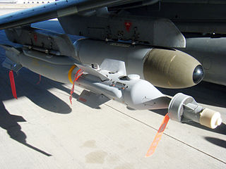
Paveway IV is a dual mode GPS/INS and laser-guided bomb manufactured by Raytheon UK. It is the latest iteration of the Paveway series.

A satellite navigation or satnav system is a system that uses satellites to provide autonomous geopositioning. A satellite navigation system with global coverage is termed global navigation satellite system (GNSS). As of 2023, four global systems are operational: the United States’s Global Positioning System (GPS), Russia's Global Navigation Satellite System (GLONASS), China's BeiDou Navigation Satellite System, and the European Union's Galileo.

The automatic identification system (AIS) is an automatic tracking system that uses transceivers on ships and is used by vessel traffic services (VTS). When satellites are used to receive AIS signatures, the term Satellite-AIS (S-AIS) is used. AIS information supplements marine radar, which continues to be the primary method of collision avoidance for water transport. Although technically and operationally distinct, the ADS-B system is analogous to AIS and performs a similar function for aircraft.
Over-the-air rekeying (OTAR) refers to transmitting or updating encryption keys (rekeying) in secure information systems by conveying the keys via encrypted electronic communication channels. It is also referred to as over-the-air transfer (OTAT), or over-the-air distribution (OTAD), depending on the specific type, use, and transmission means of the key being changed. Although the acronym refers specifically to radio transmission, the technology is also employed via wire, cable, or optical fiber.
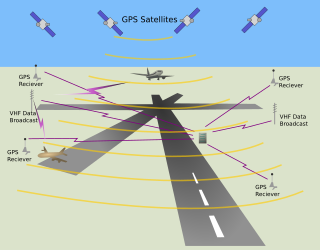
The local-area augmentation system (LAAS) is an all-weather aircraft landing system based on real-time differential correction of the GPS signal. Local reference receivers located around the airport send data to a central location at the airport. This data is used to formulate a correction message, which is then transmitted to users via a VHF Data Link. A receiver on an aircraft uses this information to correct GPS signals, which then provides a standard instrument landing system (ILS)-style display to use while flying a precision approach. The FAA has stopped using the term LAAS and has transitioned to the International Civil Aviation Organization (ICAO) terminology of ground-based augmentation system (GBAS). While the FAA has indefinitely delayed plans for federal GBAS acquisition, the system can be purchased by airports and installed as a Non-Federal navigation aid.
The joint precision approach and landing system (JPALS) is a ship's system, all-weather landing system based on real-time differential correction of the Global Positioning System (GPS) signal, augmented with a local area correction message, and transmitted to the user via secure means. The onboard receiver compares the current GPS-derived position with the local correction signal, deriving a highly accurate three-dimensional position capable of being used for all-weather approaches via an Instrument Landing System-style display. While JPALS is similar to Local Area Augmentation System, but intended primarily for use by the military, some elements of JPALS may eventually see their way into civilian use to help protect high-value civilian operations against unauthorized signal alteration.
Wide Area GPS Enhancement (WAGE) is a method to increase the horizontal accuracy of the GPS encrypted P(Y) Code by adding additional range correction data to the satellite broadcast navigation message.
GPS Block III consists of the first ten GPS III satellites, which will be used to keep the Navstar Global Positioning System operational. Lockheed Martin designed, developed and manufactured the GPS III Non-Flight Satellite Testbed (GNST) and all ten Block III satellites. The first satellite in the series was launched in December 2018.

GPS signals are broadcast by Global Positioning System satellites to enable satellite navigation. Receivers on or near the Earth's surface can determine location, time, and velocity using this information. The GPS satellite constellation is operated by the 2nd Space Operations Squadron (2SOPS) of Space Delta 8, United States Space Force.

The AN/PSN-13 Defense Advanced GPS Receiver is a handheld GPS receiver used by the United States Department of Defense and select foreign military services. It is a military-grade, dual-frequency receiver, and has the security hardware necessary to decode the encrypted P(Y)-code GPS signals.

The AN/PSN-11 Precision Lightweight GPS Receiver is a ruggedized, hand-held, single-frequency GPS receiver fielded by the United States Armed Forces. It incorporates the Precise Positioning Service — Security Module (PPS-SM) to access the encrypted P(Y)-code GPS signal.

A satellite navigation device, satnav device or satellite navigation receiver is a user equipment that uses one or more of several global navigation satellite systems (GNSS) to calculate the device's geographical position and provide navigational advice. Depending on the software used, the satnav device may display the position on a map, as geographic coordinates, or may offer routing directions.
The error analysis for the Global Positioning System is important for understanding how GPS works, and for knowing what magnitude of error should be expected. The GPS makes corrections for receiver clock errors and other effects but there are still residual errors which are not corrected. GPS receiver position is computed based on data received from the satellites. Errors depend on geometric dilution of precision and the sources listed in the table below.
GNSS enhancement refers to techniques used to improve the accuracy of positioning information provided by the Global Positioning System or other global navigation satellite systems in general, a network of satellites used for navigation. Enhancement methods of improving accuracy rely on external information being integrated into the calculation process. There are many such systems in place and they are generally named or described based on how the GPS sensor receives the information. Some systems transmit additional information about sources of error, others provide direct measurements of how much the signal was off in the past, while a third group provides additional navigational or vehicle information to be integrated into the calculation process.
References
- 1 2 "Why Convert to a SAASM based Global Positioning System (GPS)?" (PDF). 16 March 2007. Archived from the original (PDF) on 16 March 2007.
- 1 2 "White House announcement". Archived from the original on 2016-12-23. Retrieved 2012-01-30.