Related Research Articles
Romulus is a town in Seneca County, New York, United States. The population was 3,203 at the 2020 census. The town is named after the mythical founder of Rome, Romulus, a name assigned by a clerk with an interest in the classics. It is located in the central part of the county, northwest of Ithaca, New York.
The former Seneca Army Depot occupied 10,587 acres (4,284 ha) between Seneca Lake and Cayuga Lake in Seneca County, New York. It was used as a munitions storage and disposal facility by the United States Army from 1941 until the 1990s. The property was transferred to the Seneca County Industrial Development Agency, which sold it.

Naval Air Station Alameda was a United States Navy Naval Air Station in Alameda, California, on San Francisco Bay.
Rice, formerly named Blythe Junction, is a former town in the Rice Valley and the southern tip of the Mojave Desert, and within unincorporated San Bernardino County, southern California. Although it is still on many maps, the only things remaining there are the Rice Shoe Tree and an unmanned railroad siding. There are no resident inhabitants or remaining buildings.

Norton Air Force Base (1942–1994) was a United States Air Force facility 2 miles (3.2 km) east of downtown San Bernardino in San Bernardino County, California.

Müritz Airpark, previously known as Rechlin–Lärz Airfield) is an airfield in the village of Rechlin, Mecklenburg-Western Pomerania, Germany. The airport is not used for scheduled traffic but features general aviation and is home to other leisure activities as well. Additionally, the music festival Fusion Festival takes place here.
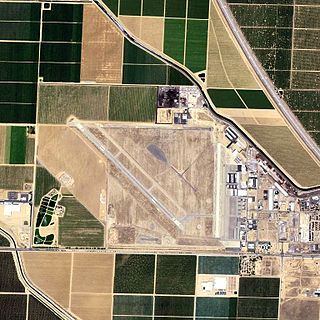
Shafter Airport, also known as Minter Field and formerly known as Air Corps Basic Flying School, is a public use airport located four nautical miles east of the central business district of Shafter and 14 miles northwest of Bakersfield, a city in Kern County, California, United States. Originally a World War II primary training facility for pilots, it is currently a public airport owned by the Minter Field Airport District. This airport is included in the National Plan of Integrated Airport Systems for 2011–2015, which categorized it as a general aviation facility.
Christchurch Airfield was located southeast of the A337/B3059 intersection in Somerford, Christchurch, Dorset, England.

Sharpe Field is a closed private use airport located six nautical miles northwest of the central business district of Tuskegee, a city in Macon County, Alabama, United States. This airport is privately owned by the Bradbury Family Partnership.
Moore Army Airfield is a former airfield located in Fort Devens, Massachusetts. It was closed following the closure of the fort in 1995. It is named for Ayer native Chief Warrant Officer 2 Douglas Moore. It was the only Army Airfield named for someone killed in the Vietnam War. It is currently used for racing and State Police driver training.

Lemoore Army Air Field, located nine miles (14 km) southwest of Lemoore, California, was a dirt air field usable only in dry weather. It nevertheless was used by the AAF Western Flying Training Command as a processing and training field.

Baltimore Municipal Airport is a former airport and United States Air Force airfield about 6 miles southeast of Baltimore, Maryland, on an artificial peninsula. Construction began in 1929 with a seaplane base and was completed in 1941. It closed on 30 December 1960. The western half of the airport was within the city of Baltimore, whereas the eastern half was in Dundalk, in Baltimore County.

Sampson Air Force Base is a closed United States military facility, last used by the United States Air Force Air Training Command as a Basic Military Training Center. It was closed in 1956 and put into caretaker status.

Eagle Pass Army Airfield is a former World War II military airfield complex. It is located 10.6 miles (17.1 km) north of Eagle Pass, Texas. It operated as a training base for the United States Army Air Forces from 1943 until 1945.

Bangor Air National Guard Base is a United States Air National Guard base located on the grounds of Bangor International Airport in Bangor, Maine.

Helm Field also called Lemoore Auxiliary Army Airfield A-7 is a former US Army Airfield use for training during World War II. Helm Field was location in the town of Coalinga, California, 70 miles south of Fresno. Helm Field had two 3,000 foot runways, one oriented east/west and one oriented northwest–southeast. The Airfield was on a 773 acres site of form farm land. The US Army purchased the land on January 11, 1943 for training pilots. The Airfield was used by the Lemoore Basic Flying School, based at the Lemoore Army Air Field. Helm Field was 15 miles northwest of Lemoore Army Air Field. The Army built at Helm Field to support training stage house, control tower, motor pool building, crash truck shelter and latrines. Helm Field was used by Air Corps Basic Flying School, the AAF Basic Flying School, the AAF Pilot School, the 88th Air Base Squadron, the 3023rd Army Air Force Pilot School and the 461st Army Air Force Base Unit. The army closed Helm Field on October 15, 1844 and the Airfield was sold by the War Assets Administration. Helm Field was used as a farm labor camp in the 1950s. The east–west runway was returned to farmland. The northwest–southeast runway was still intact and was used as a civilian airfield till 1971.

Minter Army Airfield auxiliary fields were a number of airfields used during World War II to support the Minter Army Airfield near Shafter, California. Minter Army Airfield was also called Lerdo Field, after the nearby road. Minter Army Airfield also housed the Shafter Gap Filler Annex P-59A and Shafter Army Aviation Test Activity and opened in June 1941. An Army depot open on the base in October 1941, the Minter Sub-Depot, a division of the Sacramento Air Depot. Minter Army Airfield had 7,000 troops and civilians working at the base.
Victorville Army Airfield auxiliary fields were four airfields used during World War II to support the Victorville Army Airfield pilot training near Victorville, California, and Adelanto, California. After the war the Victorville Army Airfield was renamed George Air Force Base on January 13, 1948. The airfields were built in 1941 by the United States Army Air Corps just before the war. Victorville Army Airfield covered 2,200-acre in the Mojave Desert. The US Army held a groundbreaking ceremony on 12 July 1941. The base, called Victorville Army Flying School, was ready to use before the attack on Pearl Harbor on December 7, 1941. The Army built four runways in a triangle configuration, with one runway down the middle of the triangle. Seven hangars were built to support operation. On April 23, 1943, the base was renamed Victorville Army Airfield.

Naval Air Station Los Alamitos Naval Outlying Landing Fields were a set airfield near Naval Air Station Los Alamitos to support the training of US Navy pilots during World War 2. The support airfields are called Naval Outlying Landing Field (NOLF). For the war, many new trained pilots were needed. The Naval Outlying Landing Fields provided a place for pilots to practice landing and take off without other air traffic. The remotes sites offered flight training without distractions. Most of the new pilots departed to the Pacific War after training. The Outlying Landing Fields had little or no support facilities. Naval Air Station Los Alamitos opened in 1942 and was transferred to the US Army in 1977 as Los Alamitos Army Airfield. Most of the Outlying fields closed in 1945, having completed the role of training new pilots. To open the needed Outlying Landing Fields quickly, the Navy took over local crop dusting and barnstorming airfields. Naval Air Station Los Alamitos was also called Los Alamitos Naval Reserve Air Base. During the war Marine Corps Air Station El Toro also used the outlying Landing Field. The Timm N2T Tutor was the most common plane used for training on the outlying landing fields.

Naval Base Hawaii was a number of United States Navy bases in the Territory of Hawaii during World War II. At the start of the war, much of the Hawaiian Islands was converted from tourism to a United States Armed Forces base. With the loss of US Naval Base Philippines in Philippines campaign of 1941 and 1942, Hawaii became the US Navy's main base for the early part of the island-hopping Pacific War against Empire of Japan. Naval Station Pearl Harbor was founded in 1899 with the annexation of Hawaii.
References
- ↑ "Abandoned & Little-Known Airfields: New York State: Rochester area". Abandoned & Little-Known Airfields. 3 March 2012. Retrieved 31 May 2015.