
Vinson Massif is a large mountain massif in Antarctica that is 21 km (13 mi) long and 13 km (8.1 mi) wide and lies within the Sentinel Range of the Ellsworth Mountains. It overlooks the Ronne Ice Shelf near the base of the Antarctic Peninsula. The massif is located about 1,200 kilometres (750 mi) from the South Pole. Vinson Massif was discovered in January 1958 by U.S. Navy aircraft. In 1961, the Vinson Massif was named by the Advisory Committee on Antarctic Names (US-ACAN), after Carl G. Vinson, United States congressman from the state of Georgia, for his support for Antarctic exploration. On November 1, 2006, US-ACAN declared Mount Vinson and Vinson Massif to be separate entities.

The Ellsworth Mountains are the highest mountain ranges in Antarctica, forming a 360 km (224 mi) long and 48 km (30 mi) wide chain of mountains in a north to south configuration on the western margin of the Ronne Ice Shelf in Marie Byrd Land. They are bisected by Minnesota Glacier to form the Sentinel Range to the north and the Heritage Range to the south. The former is by far the higher and more spectacular with Mount Vinson (4,892 m) constituting the highest point on the continent. Geologically, they are part of the Antarctandes which stretch from the Antarctic Peninsula to Cape Adare on the western shore of the Ross Sea. The Antarctandes form the southernmost arc of the Pacific 'Ring of Fire'. The mountains are located within the Chilean Antarctic territorial claim but outside of the Argentinian and British ones.

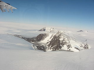
Mount Tyree (4852m) is the second highest mountain of Antarctica located 13 kilometres northwest of Vinson Massif (4,892 m), the highest peak on the continent. It surmounts Patton Glacier to the north and Cervellati Glacier to the southeast.
The Thiel Mountains are an isolated, mainly snow-capped mountain range of the Transantarctic Mountains System, located in the Ellsworth Land region of Antarctica

Marie Byrd Land is the portion of West Antarctica lying east of the Ross Ice Shelf and the Ross Sea and south of the Pacific Ocean, extending eastward approximately to a line between the head of the Ross Ice Shelf and Eights Coast. It stretches between 158°W and 103°24'W. The inclusion of the area between the Rockefeller Plateau and Eights Coast is based upon the leading role of the American Rear Admiral Richard E. Byrd in the exploration of this area. The name was originally applied by Admiral Byrd in 1929, in honor of his wife, to the northwestern part of the area, the part that was explored in that year.
The Behrendt Mountains is a group of mountains, 32 km long, aligned in the form of a horseshoe with the opening to the southwest, standing 11 km SW of Merrick Mountains at the base of the Antarctic Peninsula. Discovered and photographed from the air by the RARE, 1947-48, under Finn Ronne.
The Merrick Mountains. are a cluster of mountains, 13 km long, standing 11 km northeast of the Behrendt Mountains in Palmer Land, Antarctica. Discovered and photographed from the air by the Ronne Antarctic Research Expedition, 1947–1948, under Finn Ronne.

Toney Mountain is an elongated snow-covered shield volcano, 60 km (38 mi) long and rising to 3,595 m in Richmond Peak, located 56 km (35 mi) SW of Kohler Range in Marie Byrd Land, Antarctica.

Pine Island Glacier (PIG) is a large ice stream, and the fastest melting glacier in Antarctica, responsible for about 25% of Antarctica's ice loss. The glacier ice streams flow west-northwest along the south side of the Hudson Mountains into Pine Island Bay, Amundsen Sea, Antarctica. It was mapped by the United States Geological Survey (USGS) from surveys and United States Navy (USN) air photos, 1960–66, and named by the Advisory Committee on Antarctic Names (US-ACAN) in association with Pine Island Bay.
The Ronne Antarctic Research Expedition (RARE) was an expedition from 1947–1948 which researched the area surrounding the head of the Weddell Sea in Antarctica.

The Tangra 2004/05 Expedition was commissioned by the Antarctic Place-names Commission at the Ministry of Foreign Affairs of Bulgaria, managed by the Manfred Wörner Foundation, and supported by the Bulgarian Antarctic Institute, the Institute of Mathematics and Informatics at the Bulgarian Academy of Sciences, Bulgarian Posts Plc; the Uruguayan Antarctic Program, Peregrine Shipping (Australia), and Petrol Ltd, TNT, Mtel, Bulstrad, Polytours, B. Bekyarov and B. Chernev (Bulgaria).

Mount Anderson is a high mountain in the northern part of the Sentinel Range in Ellsworth Mountains, Antarctica. Probuda Ridge is trending northeast of the peak, and Embree Glacier and Ellen Glacier's tributary Fonfon Glacier drain its northeastern and eastern slopes respectively. It is part of the same massif as Mount Bentley and Mount Sisu.

Mount Press is a peak rising to 3,830 m in the north-central Sentinel Range in Ellsworth Mountains, Antarctica. It is linked to Eyer Peak by Zvegor Saddle, and surmounts Embree Glacier to the north and Ellen Glacier to the southeast. Mount Press is the summit of Probuda Ridge, and was first ascended by the American Jed Brown and the Chileans Camilo Rada and Maria Paz 'Pachi' Ibarra on 31 December 2006.

Antarctica is Earth's southernmost continent. It contains the geographic South Pole and is situated in the Antarctic region of the Southern Hemisphere, almost entirely south of the Antarctic Circle, and is surrounded by the Southern Ocean. At 14,000,000 square kilometres, it is the fifth-largest continent. For comparison, Antarctica is nearly twice the size of Australia. About 98% of Antarctica is covered by ice that averages 1.9 km in thickness, which extends to all but the northernmost reaches of the Antarctic Peninsula.
Mount Bentley is a mountain (4,245 m) standing 2 nautical miles north of Mount Anderson in the main western ridge of the Sentinel Range, Antarctica. It was discovered by the Marie Byrd Land Traverse party, 1957–58, and named for Dr. Charles R. Bentley, leader of the traverse party and chief traverse seismologist at Byrd Station, 1957-59.
The Long Gables are prominent twin peaks, with heights of 4,150 and 4,110 metres, joined by a col, with the lower rock exposures being in the form of steep buttresses. The peaks rise from the main ridge of the Sentinel Range, Ellsworth Mountains, Antarctica between Mount Anderson and Mount Viets. They surmount Burdenis Glacier to the southeast, Gerila Glacier to the east and Fonfon Glacier to the northeast.

Clarke Glacier is a 2-mile-wide, 20-mile-long glacier, located on the west coast of Graham Land in Antarctica. It flows west, along the north side of Sickle Mountain and the Baudin Peaksm, to Mikkelsen Bay.
Mount Hale is a mountain standing 1.5 mi NW of Mount Davis in the main ridge of the Sentinel Range, Antarctica. Discovered by the Marie Byrd Land Traverse party, 1957–58, under C.R. Bentley, and named for Daniel P. Hale, auroral physicist at Byrd Station and member of the traverse party.