
The Adirondack Park is a park in northeastern New York protecting the Adirondack Mountains. The park was established in 1892 for "the free use of all the people for their health and pleasure", and for watershed protection. At 6.1 million acres, it is the largest park in the contiguous United States.

Hunter Mountain is in the towns of Hunter and Lexington, just south of the village of Hunter, in Greene County, New York, United States. At approximately 4,040 feet (1,231 m) in elevation, it is the highest peak in the county and the second-highest peak in the Catskill Mountains.

Whiteface Mountain is the fifth-highest mountain in the U.S. state of New York, and one of the High Peaks of the Adirondack Mountains, located in the town of Wilmington in Essex County. Set apart from most of the other High Peaks, the summit offers a 360-degree view of the Adirondacks and clear-day glimpses of Vermont and Canada, where Montreal can be seen on a very clear day. Because of its relative isolation, the mountain is exposed to prevailing winds from the west and frequently capped with snow and ice, making it an area of interest to meteorologists. Weather data has been collected on the summit since 1937. The mountain's east slope is home to a major ski area which boasts the greatest vertical drop east of the Rockies, and which hosted the alpine skiing competitions of the 1980 Winter Olympics. Unique among the High Peaks, Whiteface features a developed summit and seasonal accessibility by motor vehicle. The Whiteface Veterans Memorial Highway reaches a parking area at an elevation shortly below the summit, with the remaining distance covered by tunnel and elevator. The peak can also be reached on two hiking trails.
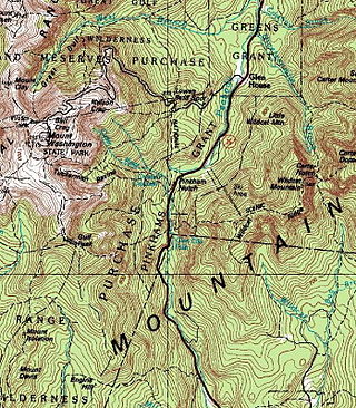
Pinkham Notch is a mountain pass in the White Mountains of north-central New Hampshire, United States. The notch is a result of extensive erosion by the Laurentide Ice Sheet during the Wisconsinian ice age. Pinkham Notch was eroded into a glacial U-shaped valley whose walls are formed by the Presidential, Wildcat, and Carter-Moriah ranges. Due to the volatility of the area's climate and rugged character of the terrain, a number of rare or endemic ecosystems have developed throughout the notch.

The Tongue Mountain Range Trails are a series of hiking trails located within the Tongue Mountain Range, a subordinate range within the Adirondack Mountains of New York. The trails, 25 miles (40 km) in total length, vary from easy walks along the foot of the mountains on the shore of adjacent Lake George, to more rugged ascents of mountain peaks within the range.
The Blue Ridge Wilderness Area, a unit of New York's Forest Preserve in the Adirondack Park, is located in the towns of Arietta, Lake Pleasant and Indian Lake in Hamilton County. It is roughly bounded on the north by NY 28; on the east by Route 28 and private lands immediately west of this route; on the south by private lands immediately north and west of Cedar River Flow; and on the west by the Lake Kora and Sagamore Lake properties and the South Inlet of Raquette Lake. It contains 19 bodies of water covering 275 acres and features 15 miles of foot trails and three lean-tos.

The Dix Mountain Wilderness Area is the name previously given to an area of New York's Forest Preserve in the Adirondack Park located in the towns of Elizabethtown, Keene and North Hudson, Essex County. It was roughly bounded on the north by NY 73, on the east by the Adirondack Northway (Interstate 87), on the south by Blue Ridge Road and on the west by Elk Lake Club and Ausable Club lands.
The Five Ponds Wilderness Area, an Adirondack Park unit of New York's Forest Preserve, is located in the towns of Fine and Clifton in St. Lawrence County, the town of Webb in Herkimer County and the town of Long Lake in Hamilton County. It includes 1,064 acres (4.3 km2) of private inholdings, 99 bodies of water covering 1,964 acres (7.9 km2), 57.9 miles (93.2 km) of trails, and 14 lean-tos.
The Giant Mountain Wilderness Area, an Adirondack Park unit of New York's Forest Preserve, lies in Essex County, New York, in the towns of Elizabethtown and Keene. It is roughly bounded by NY 9N on the north, NY 73 on the west and south and US 9 on the east. It includes two bodies of water covering 5 acres, 12.5 miles (20.1 km) of trails, and a single lean-to.
The High Peaks Wilderness Area is the largest wilderness area of the Forest Preserve in the U.S. state of New York. It is located in three counties and six towns in the Adirondack Park: Harrietstown in Franklin County, North Elba, Keene, North Hudson and Newcomb in Essex County and Long Lake in Hamilton County.

The Ha-De-Ron-Dah Wilderness Area, an Adirondack Park unit of New York's Forest Preserve, is located in the town of Webb, Herkimer County, and the Town of Greig, Lewis County. It is bounded on the north by private lands in the vicinity of North Pond, Hitchcock Pond, Moose Pond and the headwaters of the Independence River; on the east by private lands along the Remsen to Lake Placid railroad right-of-way; on the south by private lands along New York State Route 28 and by the wood road leading to the Copper Lake property; and on the west by Pine Creek and a DEC maintained foot trail from Pine Creek to Pine Lake, East Pine Pond, and Big Otter Lake.
The Hoffman Notch Wilderness Area, an Adirondack Park unit of the Forest Preserve, lies in the towns of Schroon, North Hudson and Minerva in Essex County. It is bounded on the north by private lands lying south of the Blue Ridge Road and the Sand Pond Mountain tract donated to the state by Finch, Pruyn and Company for fish and wildlife management and silvicultural research and experimentation purposes, on the east by Interstate 87 and private lands immediately west of the Northway, on the south by private lands lying north of the Loch Muller Road and on the west by the jeep road and trail that extends from Irishtown along Minerva Stream northward to the Blue Ridge Road near Cheney Pond.
The McKenzie Mountain Wilderness Area, an Adirondack Park unit of the Forest Preserve, lies in western Essex County in the towns of St. Armand, North Elba and Wilmington. In general, the Saranac River and Franklin Falls Pond border on the north; the Wilmington-Franklin Falls road, the Whiteface Mountain Memorial Highway and the west branch of the Ausable River form the eastern boundary; the Saranac Lake-Lake Placid Road, NY 86, forms the southern boundary; and the Saranac River forms the western boundary.
The Pepperbox Wilderness Area, an Adirondack Park unit of the New York Forest Preserve, lies entirely within the town of Webb in Herkimer County. Stillwater Reservoir and the Beaver River Primitive Area form the southern boundary, while the north bank of the West Branch of the Oswegatchie River generally forms the northern boundary. The western boundary is the county line, and the eastern boundary is the Raven Lake Road and the Five Ponds Wilderness Area.
The Pharaoh Lake Wilderness Area, an Adirondack Park unit of New York's Forest Preserve, straddles the Essex County-Warren County line in the towns of Ticonderoga, Hague, Horicon and Schroon. The county road along the east shore of Schroon Lake forms the western boundary; to the north, private land and NY 74 form the boundary. The state land boundary forms most of the remaining perimeter except for a stretch of NY 8 on the south.
The Pigeon Lake Wilderness Area, an Adirondack Park unit of the forest preserve, lies in the town of Webb, Herkimer County, and the towns of Long Lake and Inlet in Hamilton County. It is bounded on the north by Stillwater Reservoir and large blocks of private land in the vicinity of Rose Pond, Shingle Shanty Pond and Upper Sister Lake; on the east by a private road from Brandreth Lake to North Point and by Raquette Lake; on the south by private lands along the Uncas Road; and on the west by the Big Moose Road, private lands near Big Moose Lake, Thirsty Pond, Twitchell Lake, Razorback Pond, and the Remsen to Lake Placid railroad tracks.
The Siamese Ponds Wilderness Area, an Adirondack Park unit of the Forest Preserve, is located in the towns of Lake Pleasant, Wells and Indian Lake in Hamilton County and the towns of Johnsburg and Thurman in Warren County. It is one of the larger wilderness areas of the Northeast; extending about 18 miles (29 km) from north to south and about 13 miles (21 km) from east to west at its widest part.
The Silver Lake Wilderness Area, an Adirondack Park unit of the Forest Preserve, is located in the towns of Lake Pleasant, Benson, Wells and Arietta in Hamilton County and is roughly bounded on the north by NY 8 and private lands near Piseco Lake, Oxbow Lake, Hamilton Lake, Sand Lake and Lake Pleasant; on the east by NY 30; on the south generally by the Hamilton County line; and on the west by NY 10, the West Branch of the Sacandaga River and the Piseco Outlet.
The West Canada Lake Wilderness Area is an Adirondack Park Forest Preserve management unit in the State of New York, USA.

The Northeastern Highlands Ecoregion is a Level III ecoregion designated by the United States Environmental Protection Agency (EPA) in the U.S. states of Vermont, New Hampshire, Massachusetts, Maine, Connecticut, New York, New Jersey, and Pennsylvania. The ecoregion extends from the northern tip of Maine and runs south along the Appalachian Mountain Range into eastern Pennsylvania. Discontiguous sections are located among New York's Adirondack Mountains, Catskill Range, and Tug Hill. The largest portion of the Northeastern Highlands ecoregion includes several sub mountain ranges, including the Berkshires, Green Mountains, Taconic, and White Mountains.
