Related Research Articles

An alvar is a biological environment based on a limestone plain with thin or no soil and, as a result, sparse grassland vegetation. Often flooded in the spring, and affected by drought in midsummer, alvars support a distinctive group of prairie-like plants. Most alvars occur either in northern Europe or around the Great Lakes in North America. This stressed habitat supports a community of rare plants and animals, including species more commonly found on prairie grasslands. Lichen and mosses are common species. Trees and bushes are absent or severely stunted.

The Staten Island Greenbelt is a system of contiguous public parkland and natural areas in the central hills of the New York City borough of Staten Island. It is the second largest component of the parks owned by the government of New York City and is maintained by the city's Department of Parks and Recreation and the Greenbelt Conservancy, a not-for-profit organization that works in partnership with NYC Parks to care for the Greenbelt and raise funds for its maintenance and programs. The Greenbelt includes High Rock Park, LaTourette Park, William T. Davis Wildlife Refuge, and Willowbrook Park among others.
Clay Pit Ponds State Park Preserve is 265-acre (1.07 km2) state park located near the southwestern shore of Staten Island, New York. It is the only state park located on Staten Island.
Long Pond is an unincorporated community in Monroe County in the Pocono Mountains region of Pennsylvania, a part of the Appalachian Mountains. Long Pond is located within the Tunkhannock Creek Watershed. Its ZIP code is 18334.
Graniteville is the name of a neighborhood in Staten Island, one of the five boroughs of New York City.
Grymes Hill is a 374 feet (114 m) tall hill formed of serpentine rock on Staten Island, New York. It is the second highest natural point on the island and in the five boroughs of New York City. The neighborhood of the same name encompasses an area of 0.894 square miles (2.32 km2) and has a population of 8,263 people. The hill also includes parts of the Silver Lake neighborhood. The area includes part of ZIP Codes 10301 and 10304.

Emerson Hill is the name of a hilly area, and the neighborhood upon which the hill is situated in Staten Island, New York, one of the five boroughs of New York City, United States.

Serpentine soil is an uncommon soil type produced by weathered ultramafic rock such as peridotite and its metamorphic derivatives such as serpentinite. More precisely, serpentine soil contains minerals of the serpentine subgroup, especially antigorite, lizardite, and chrysotile or white asbestos, all of which are commonly found in ultramafic rocks. The term "serpentine" is commonly used to refer to both the soil type and the mineral group which forms its parent materials.

The Long Island Central Pine Barrens is a large area of publicly protected pine barrens in Suffolk County, New York, on Long Island, covering more than 100,000 acres (405 km2).

Soldiers Delight Natural Environmental Area is a nature reserve near Owings Mills in western Baltimore County, Maryland, U.S. The site is designated both as a Maryland Wildland and as a Natural Environment Area and is part of the Maryland Wildlands Preservation System. The site's protected status is due to the presence of serpentine soil and over 39 rare, threatened, or endangered plant species along with rare insects, rocks and minerals.
Ice Mountain is a mountain ridge and algific talus slope that is part of a 149-acre (60 ha) preserve near the community of North River Mills in Hampshire County, West Virginia, United States. It was designated a National Natural Landmark in 2012.

Barren vegetation describes an area of land where plant growth may be sparse, stunted, and/or contain limited biodiversity. Environmental conditions such as toxic or infertile soil, high winds, coastal salt-spray, and climatic conditions are often key factors in poor plant growth and development. Barren vegetation can be categorized depending on the climate, geology, and geographic location of a specific area.

Tropical hardwood hammocks are closed canopy forests, dominated by a diverse assemblage of evergreen and semi-deciduous tree and shrub species, mostly of West Indian origin. Tropical hardwood hammocks are found in South Florida or the Everglades, with large concentrations on the Miami Rock Ridge, in the Florida Keys, along the northern shores of Florida Bay, and in the Pinecrest region of the Big Cypress Swamp.
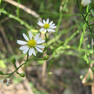
Symphyotrichum depauperatum, commonly known as serpentine aster or starved aster, is a rare species in the family Asteraceae adapted to serpentine barrens, an ecosystem with a high concentration of toxic metals in the soil. It has been found in Pennsylvania, Maryland, and on some diabase glades in North Carolina. It grows to 50 centimeters and has white ray florets surrounding a center of yellow disk florets.
The Staten Island Serpentinite locality is a southward extension of the New England Uplands, adjacent to the Manhattan Prong. It includes Todt Hill on Staten Island, which is the highest point along the Atlantic Seaboard south of Maine, at 410 feet (120 m) above sea level. "Todt" is a Dutch word meaning "dead." This hill perhaps received its name from the Dutch settlers because the hilltops overlooking The Narrows consisted of scattered treeless rocky exposures. The chemical character of the bedrock was, in part, the reason for this. Much of Staten Island is covered by the Harbor Hill moraine, the terminal moraine of the last Wisconsin Stage glacier. However, ledges of bedrock consisting of serpentinite are exposed throughout the upland areas on Staten Island. Grymes Hill, the second highest point on Staten Island and just a few miles from Todt Hill has similar bedrock characteristics. Serpentine, the dominant mineral in serpentinite, is rich in magnesium, an element that most plants cannot tolerate in high concentrations. The enrichment of magnesium in the thin serpentine soil covering the glacier-scoured hilltops is probably responsible for the original barren exposures on Todt Hill.
The Serpentine Art and Nature Commons is a not-for-profit organization founded in 1978. SANC is dedicated to preserving and maintaining the woodlands and serpentine ridge on the east shore of Staten Island and more specifically within the neighborhoods of Grymes Hill and Silver Lake.
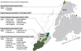
The Special Hillsides Preservation District was created in 1987 by the City of New York to preserve the hilly terrains of the North Shore of Staten Island. The district maintains different planning rules to the rest of the City to account for the geological and bio diversity of the area. The district's goals are to reduce hillside erosion, landslides, and excessive storm-water runoff by conserving vegetation and protecting natural terrain; preserve hillsides with unique aesthetic value; protect areas of outstanding natural beauty; and protect neighborhood character.
Graniteville Quarry Park is a public park operated by the New York City Department of Parks and Recreation, located on the North Shore of Staten Island, in the Graniteville area. The park is bordered on the north by Forest Avenue, on the south by Wilcox Street, on the east by the Christ United Methodist Church property and the backyards of private homes, all on Eunice Place, and on the west by Van Name Avenue, and in places, backyards of homes on that same street.

State Line Serpentine Barrens is a 60-square-mile (160 km2) tract of serpentine barrens in Pennsylvania and Maryland in the eastern United States. The protected area is actually an assemblage of six tracts owned by a combination of the Nature Conservancy, the State of Pennsylvania, two counties, a township, and private owners. The largest tract is Nottingham County Park in Chester County, which has also been deemed a National Natural Landmark. The second-largest is Goat Hill Serpentine Barrens, jointly owned by the Nature Conservancy and the Pennsylvania Forestry Department, and the third-largest, Chrome Serpentine Barrens, is jointly owned by Elk Township and the Nature Conservancy. Rock Springs Preserve in Lancaster County is managed by the Lancaster Conservancy.
References
- ↑ Hughes, C. J. (2016-07-06). "Grymes Hill: Manhattan Views, West Coast Feel". The New York Times. ISSN 0362-4331 . Retrieved 2019-10-26.
- ↑ "Chapter 9 | Zoning Resolution". zr.planning.nyc.gov. Retrieved 2019-10-26.
- ↑ "A NYC Parkland, Serpentine Art & Nature Commons". www.preserve.org. Retrieved 2019-10-26.
- ↑ "Observations · iNaturalist". iNaturalist. Retrieved 2019-11-22.
- ↑ "Geology of Staten Island". academic.brooklyn.cuny.edu. Retrieved 2019-10-27.
- ↑ "NYC Planning ZAP Search". zap.planning.nyc.gov. Retrieved 2021-08-20.