
Warren County is a county located in the U.S. state of Georgia. As of the 2020 United States census, the population was 5,215, a decrease from 2010. The county seat is Warrenton. The county was created on December 19, 1793, and is named after General Joseph Warren, who was killed in the Battle of Bunker Hill.

Pierce County is a county located in the southeastern part of the U.S. state of Georgia. As of the 2020 census, the population was 19,716. The county seat is Blackshear.

Jefferson County is a county located in the U.S. state of Georgia. As of the 2020 census, the population was 15,709. The county seat and largest city is Louisville. The county was created on February 20, 1796, and named for Thomas Jefferson, the main author of the Declaration of Independence who became the third president of the United States.

Glascock County is a county located in the U.S. state of Georgia. As of the 2020 census, the population was 2,884, making it the fourth-least populous county in Georgia. The county seat is Gibson. The county was created on December 19, 1857.

Douglas is a city in Coffee County, Georgia, United States. As of the 2020 census, the city had a population of 11,722. Douglas is the county seat of Coffee County and the core city of the Douglas micropolitan statistical area, which had a population of 50,731 as of the 2010 census.
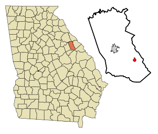
Gibson is a city and the county seat of Glascock County, Georgia, United States, and is home to the Glascock County Courthouse, a National Register of Historic Places listed site. The population was 663 at the 2010 census, and 630 in 2020.

Lincolnton is a city and the county seat of Lincoln County, Georgia, United States. The population was 1,480 at the 2020 census. It contains numerous houses and historic districts listed on the National Register of Historic Places. Both the city and the county were named for General Benjamin Lincoln, who served in the Continental Army during the American Revolution.
Dearing is a town in McDuffie County, Georgia, United States. The population was 529 at the 2020 census. It is part of the Augusta metropolitan area.

Uvalda is a city in Montgomery County, Georgia, United States. The population was 439 at the 2020 census, down from 598 in 2010.

Deepstep is a town in Washington County, Georgia, United States. The population was 117 in 2020.
The Alabaha River is a 20.6-mile-long (33.2 km) tributary of the Satilla River in the U.S. state of Georgia. It forms in northwestern Pierce County at the junction of Hurricane Creek and Little Hurricane Creek and flows southeast, past the county seat of Blackshear, and joins the Satilla River at the Pierce County/Brantley County boundary.
Alligator Creek is a 48.6-mile-long (78.2 km) tributary of the Little Ocmulgee River in the U.S. state of Georgia.

Big Satilla Creek is a 55.8-mile-long (89.8 km) tributary of the Little Satilla River in the U.S. state of Georgia. It is part of the Satilla River watershed of southeastern Georgia.
The Big Satilla River is a river in South Georgia. It rises in Ben Hill and Coffee counties and flows southeast for 260 miles (420 km). It is one of Georgia's 14 major watersheds.

The Little Satilla Creek is a 39.3-mile-long (63.2 km) tributary of the Little Satilla River in the U.S. state of Georgia. It is part of the Satilla River watershed in southeastern Georgia.
Rocky Comfort Creek is a 62.4-mile-long (100.4 km) tributary of the Ogeechee River in the U.S. state of Georgia. Rising in Warren County 9 miles (14 km) northwest of Warrenton, it flows southeast, entering Glascock County and passing the town of Gibson, then continuing south into Jefferson County, where it reaches the Ogeechee River at Louisville.
Suwannoochee Creek is a 49.0-mile-long (78.9 km) tributary of the Suwannee River in the U.S. state of Georgia. It rises in western Clinch County, Georgia, about 11 miles (18 km) west of Homerville, and flows southeast to join the Suwannee near Fargo. For the lower half of its course it forms the boundary between Clinch and Echols counties.
The Williamson Swamp Creek is a 52.4-mile-long (84.3 km) tributary of the Ogeechee River in the U.S. state of Georgia. Rising in northwestern Washington County 12 miles (19 km) north of Sandersville, it flows southeast past Davisboro and enters Jefferson County, ending at the Ogeechee River 5 miles (8 km) southeast of Wadley.
Broxton Creek is a stream in the U.S. state of Georgia. It is a tributary to the Seventeen Mile River.
Fivemile Creek is a stream in the U.S. state of Georgia. It is a tributary to the Altamaha River.
