
The European influence in Afghanistan refers to political, social, and mostly imperialistic influence several European nations and colonial powers have had on the historical development of Afghanistan.

The Geography of Pakistan is a profound blend of landscapes varying from plains to deserts, forests, hills, and plateaus ranging from the coastal areas of the Arabian Sea in the south to the mountains of the Karakoram range in the north. Pakistan geologically overlaps both with the Indian and the Eurasian tectonic plates where its Sindh and Punjab provinces lie on the north-western corner of the Indian plate while Balochistan and most of the Khyber Pakhtunkhwa lie within the Eurasian plate which mainly comprises the Iranian Plateau. Gilgit-Baltistan and Azad Kashmir lie along the edge of the Indian plate and hence are prone to violent earthquakes where the two tectonic plates collide.

The Afrīdī is a Pashtun tribe present in Pakistan, with substantial numbers in Afghanistan. The Afridis are most dominant in Pakistan's Federally Administered Tribal Areas, inhabiting about 100p mi² (3000 km²) of rough hilly area in the eastern Spin Ghar range west of Peshawar, covering most of Khyber Agency, FR Peshawar and FR Kohat. Their territory includes the Khyber Pass and Maidan in Tirah. Afridi migrants are also found in India, mostly in the states of Uttar Pradesh, Bihar and Jammu and Kashmir.

Sir Pierre Louis Napoleon Cavagnari, British military administrator, was the son of Count Louis Adolphus Cavagnari, of an old Italian family from Parma in the service of the Bonaparte family, by his marriage in 1837 with an Anglo-Irish lady, Caroline Lyons-Montgomery. Cavagnari was born at Stenay, in the Meuse département, France, on 4 July 1841. He was killed on 3 September 1879 during the siege of the British Residency in Kabul in Afghanistan.
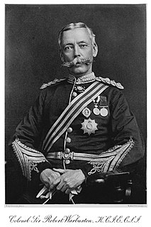
Colonel Sir Robert Warburton, was an Anglo-Indian soldier and administrator. Half-Afghan and proficient in Pashtu, he served for many years that British political officer in charge of the Khyber Pass, a region of strategic importance to British India. He helped maintain peace with the Afridis who rose in revolt eighteen years after his retirement.
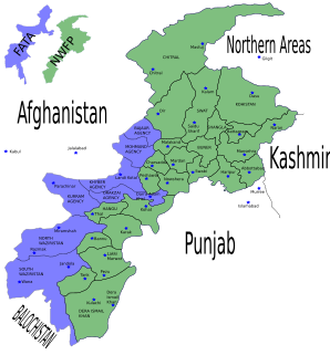
The North-West Frontier region of the British Indian Empire was a difficult area to conquer in South Asia, strategically and militarily. It remains the western frontier of present-day Pakistan, extending from the Pamir Knot in the north to the Koh-i-Malik Siah in the west, and separating the modern Pakistani frontier regions of North-West Frontier Province, Federally Administered Tribal Areas and Balochistan from neighbouring Afghanistan in the west. The borderline between is officially known as the Durand Line and divides Pashtun inhabitants of these provinces from Pashtuns in eastern Afghanistan.
Lanḍī Kōtal or Lwargai is a town in the Khyber Pakhtunkhwa province of Pakistan, and the administrative capital of Khyber Agency. It is one of the largest towns in the Federally Administered Tribal Areas, and is located 1,072 metres (3,517 ft) above sea level, on the route across the mountains to the city of Peshawar, Khyber Pakhtunkhwa, Pakistan. Landi Kotal is at the western edge of the Khyber Pass that marks the entrance to the Nangarhar Province of Afghanistan, which is located just 5 kilometres (3 mi) to the west.

The Treaty of Gandamak officially ended the first phase of the Second Anglo-Afghan War. Mohammad Yaqub Khan ceded various frontier areas to Britain while retaining full sovereignty over Afghanistan.

The Battle of Kabul was part of a punitive campaign undertaken by the British against the Afghans following the disastrous retreat from Kabul. Two British and East India Company armies advanced on the Afghan capital from Kandahar and Jalalabad to avenge the complete annihilation of its military column in January 1842. Having recovered prisoners captured during the retreat, the British demolished parts of Kabul before withdrawing to India. The action was the concluding engagement to the First Anglo-Afghan War.

The Kūnaṛ River, also known in its upper reaches as the Mastuj, Chitral, or Kama River, is about 480 km long, located in northern Khyber Pakhtunkhwa, Pakistan, and eastern Afghanistan. It emerges just south of the Broghil Pass, in the upper part of Chitral District of Khyber Pakhtunkhwa near the Afghan border. The river system is fed by melting glaciers and snow of the Hindu Kush mountains. The Kunar River is a tributary of the Kabul River, which is in turn a tributary of the Indus River.
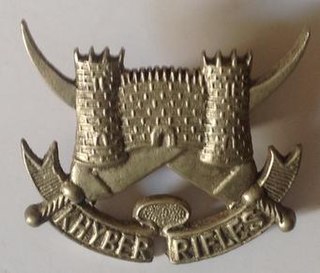
The Khyber Rifles is a para-military force forming part of the modern Pakistani paramilitary's Frontier Corps. Dating from the late nineteenth century the regiment provided the title and setting for a widely read novel, King of the Khyber Rifles.

Ali Masjid is the narrowest point of the Khyber Pass. It is located in Khyber District of Khyber Pakhtunkhwa, Pakistan. It is located around 10 miles (16 km) east of the city of Landi Kotal and has an elevation of 3,174 feet (967 m). The width of the Khyber near Ali Masjid was earlier too narrow for two fully laden camels to pass each other but since has been widened.

The Battle of Ali Masjid, which took place on 21 November 1878, was the opening battle in the Second Anglo-Afghan War between the British forces, under Lieutenant-General Sir Samuel James Browne, and the Afghan forces, under Ghulam Haider Khan. The perceived offence of an Afghan general's refusal to allow a British envoy entrance to the country was used as an excuse to attack the fortress of Ali Masjid, as the opening battle in the war. Despite numerous setbacks, including half the troops getting lost or delayed and missing the battle entirely, the British were lucky that the Afghans abandoned their position overnight.
The Khyber Pass Railway is one of several railway lines in Pakistan, operated and maintained by Pakistan Railways. The line begins at Peshawar City and ended at Landi Khana. The total length of this railway line is 58 kilometers (36 mi) with 13 railway stations. Passenger train traffic on the route has recently been suspended due to security problems and the 2006 monsoon rains, which washed several sections away.
The Second Mohmand Campaign of 1935 was a British military campaign against the Mohmand tribes in the Northwest Frontier area of British India, now Pakistan. Tanks were used, the first operational use of tanks in India. The First Mohmand Campaign in 1897–98 followed earlier military expeditions in 1851–1852, 1854, 1864, 1879, 1880. After the First Mohmand Campaign, there was an expedition in 1908 and another in 1933, taking about a month in August.
Maidan, or Tirah Maidan, is a remote valley located in the Tirah region in Khyber Agency, Pakistan.

Shagai Fort is a fort located 13 kilometres from Jamrud in Khyber Agency, Federally Administered Tribal Areas. It was built in 1927 by the British forces to oversee the Khyber Pass. The estimate terrain elevation above sea level is 847 metres. Now it’s manned by Pakistani military and paramilitary troops serving as headquarters for the Khyber Rifles — the traditional guardians of the Khyber Pass.


