Delta County is a county in the Upper peninsula in the U.S. state of Michigan. As of the 2010 United States Census, the population was 37,069. The county seat is Escanaba. The county was surveyed in 1843 and organized in 1861. Its name originates from the Greek letter "delta", which refers to the triangular shape of the original county which included segments of Menominee, Dickinson, Iron, and Marquette counties.
Gustin Township is a civil township of Alcona County in the U.S. state of Michigan. The population was 795 at the 2010 census.
Bark River is a 23.7-mile-long (38.1 km) river on the Upper Peninsula of the U.S. state of Michigan. The river flows into Green Bay on Lake Michigan in Ford River Township about 15 miles (24 km) southwest of Escanaba at 45°34′22″N87°14′34″W.

Located in northeastern Wisconsin, the Oconto River is a tributary of Lake Michigan via Green Bay. The Oconto River is 56.9 miles (91.6 km) long, stretching from the confluence of its North and South branches at Suring, Wisconsin, to Green Bay at the city of Oconto. Its drainage basin covers 2,416 square miles (6,260 km2), encompassing most of Oconto County as well as portions of Shawano, Marinette, Menominee, Langlade, and Forest counties.

Vicksburg National Military Park preserves the site of the American Civil War Battle of Vicksburg, waged from March 29 to July 4, 1863. The park, located in Vicksburg, Mississippi, also commemorates the greater Vicksburg Campaign which led up to the battle. Reconstructed forts and trenches evoke memories of the 47-day siege that ended in the surrender of the city. Victory here and at Port Hudson, farther south in Louisiana, gave the Union control of the Mississippi River.

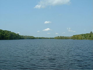
The Escanaba River is a 52.2-mile-long (84.0 km) river on the Upper Peninsula of the U.S. state of Michigan.
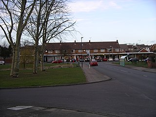
Eastern Green is a mainly residential suburb in the far west of Coventry, England, and was formerly a village in Warwickshire. Its most western area is Upper Eastern Green and the eastern area is Lower Eastern Green, though residents generally do not distinguish between the two.

The Brule River is a 52.3-mile-long (84.2 km) river in the U.S. states of Michigan and Wisconsin. Nearly the entire course forms a portion of the boundary between the two states.

Zeba is a census-designated place in L'Anse Township of Baraga County in the U.S. state of Michigan. It is located on the southern shore of Keweenaw Bay at 46°48′09″N88°24′52″W, about halfway between L'Anse and Pequaming. The community was named Zeba because of a small stream that runs southeast of it. The 2010 census recorded a population of 480 inhabitants.
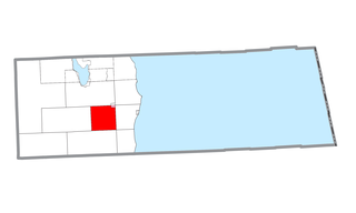
The Whitefish River is an 11.9-mile-long (19.2 km) river on the Upper Peninsula of the U.S. state of Michigan. The mouth of the river is in Delta County at 45°54′34″N86°58′01″W on the Little Bay De Noc of Lake Michigan. The main branch of the river is formed by the confluence of the east and west branches at 46°03′25″N86°52′17″W.
The Rural Municipality of Shell River was a rural municipality (RM) in the Canadian province of Manitoba. It was incorporated as a rural municipality on December 22, 1883. On January 1, 2015 it was amalgamated as a result a provincial government mandate with the RM of Hillsburg and the Town of Roblin to form the Municipality of Hillsburg – Roblin – Shell River.

Orzelec Mały is a village in the administrative district of Gmina Łubnice, within Staszów County, Świętokrzyskie Voivodeship, in south-central Poland. It lies approximately 2 kilometres (1 mi) west of Łubnice, 17 km (11 mi) south of Staszów, and 64 km (40 mi) south-east of the regional capital Kielce.
Paint River is a 45.5-mile-long (73.2 km) river in the U.S. state of Michigan.
The Medora River is a 2.1-mile-long (3.4 km) tributary of the Montreal River on the Keweenaw Peninsula of Michigan in the United States. It forms the outlet of Lake Medora.
The Moran River is a 2.2-mile-long (3.5 km) river on the Upper Peninsula of Michigan in the United States. It begins at the outlet of Chain Lake just west of St. Ignace and flows west through Freschette Lake to Lake Michigan at West Moran Bay.
The Second River is a 6.3-mile-long (10.1 km) tributary of the Middle Branch Escanaba River in Michigan.
The Walton River is a 12.2-mile-long (19.6 km) tributary of the Cedar River on the Upper Peninsula of Michigan in the United States. It joins the Cedar River at the village of Cedar River, less than 0.4 miles (0.6 km) from the mouth of the Cedar River in Lake Michigan.
The Abagadasset River is a 16.0-mile-long (25.7 km) river in Richmond and Bowdoinham, Maine, flowing into Merrymeeting Bay, part of the estuary of the Kennebec River.
The Alder River is a 6.3-mile-long (10.1 km) river in Maine. A tributary of the Androscoggin River, the Alder flows west from Locke Mills to Bethel.

Indian River is a 59.1-mile-long (95.1 km) tributary of the Manistique River on the Upper Peninsula of Michigan in the United States. It rises out of Hovey Lake at 46°17′36″N86°42′20″W on Hiawatha National Forest land in Alger County and flows south and east through a lake district and on through Schoolcraft County. The river flows into the 8,659 acre (35 km²) Indian Lake at 46°17′36″N86°42′20″W and flows out at 45°59′30″N86°17′15″W. It then flows east and south about 2.5 miles where it merges with the Manistique River, which then flows through Manistique and into Lake Michigan at 45°56′56″N86°14′45″W.