Related Research Articles
The Kavango people, also known as the vaKavango or haKavango, are a Bantu ethnic group that resides on the Namibian side of the Namibian–Angolan border along the Kavango River. They are mainly riverine living people, but about 20% reside in the dry inland. Their livelihood is based on fishery, livestock-keeping and cropping. The Kavango Region of Namibia is named after the people.

The Zambezi Region is one of Namibia's fourteen regions, situated in the north-eastern part of the country along the Zambezi River where it gets its name from. The region's capital is the town of Katima Mulilo. The Katima Mulilo Airport is 18 kilometres south-west of the town, while the village of Bukalo is located 43 kilometres south-east of Katima Mulilo. Formerly known as the Caprivi Region until 2013, it has eight electoral constituencies and a population of 142,373 according to the 2023 census.

Otjozondjupa is one of the fourteen regions of Namibia. Its capital is Otjiwarongo. The region further contains the municipalities of Okahandja and Grootfontein and the towns Okakarara and Otavi. As of 2020, Otjozondjupa had 97,945 registered voters.

Oshikoto is one of the fourteen regions of Namibia, named after Lake Otjikoto. Its capital is Omuthiya. Further major settlements in the region are Tsumeb, Otjikoto's capital until 2008, and Oniipa. As of 2020, Oshikoto had 112,170 registered voters.

Rundu is the capital and largest city of the Kavango-East Region in northern Namibia. It lies on the border with Angola on the banks of the Kavango River about 1,000 metres above sea level. Rundu's population is growing rapidly. The 2001 census counted 36,964 inhabitants; and for the 2011 census it has climbed to 63,430.
Nkurenkuru is a town on the south-western banks of the Kavango River. It is the capital of the Kavango West Region of northern Namibia, located 140 kilometres (87 mi) west of Rundu. It is also a former mission station of the Finnish Missionary Society.

Mpungu is a constituency in the Kavango West region of Namibia. It had a population of 20,787 in 2011, up from 18,660 in 2001, and 9,121 registered voters in 2020, up from 8,924 in 2004.

Kahenge was a constituency in the Kavango Region of Namibia. The district centre was the settlement of Kahenge. It had a population of 29,799 in 2011, down from 30,903 in 2001.
Mashare is a constituency in the Kavango East region of northern Namibia. The district centre is the settlement of Mashare. It had a population of 15,688 in 2011, down from 16,007 in 2001. As of 2020 the constituency had 9,165 registered voters.
Kapako is a constituency in the Kavango West region of Namibia. The district centre is the settlement of Kapako. It had a population of 26,983 in 2011, up from 26,263 in 2001.

Ndiyona is a constituency in the Kavango East region of Namibia. The district centre is the settlement of Ndiyona. It had a population of 20,633 in 2011, up from 19,565 in 2001. As of 2020 the constituency had 6,210 registered voters.
Uukwangali is a traditional kingdom of the Kavango people in northern Namibia. Its capital is Nkurenkuru, its current Hompa (king) is Eugene Siwombe Kudumo. The Uukwangali speak ruKwangali.
Gciriku is a traditional Kavango kingdom in what is today Namibia. Its people speak the Gciriku language.

Rundu Urban is an electoral constituency in the Kavango East region of Namibia. It covers the urban area of Rundu, the region's capital and one of Namibia's largest cities. The constituency also covers parts of the Sauyemwa, Safari, Tutungeni, Katutura, Donkerhoek and Kehemu neighborhoods. It had a population of 20,953 in 2011, up from 19,173 in 2001. As of 2020 the constituency had 35,740 registered voters.
Linus Shashipapo Secondary School, founded 1974 but opened its door in June, is the second oldest secondary school in the former Kavango Region of Namibia. It is named after Linus Shashipapo, Hompa (king) of the Gciriku from 1945 to 1984. Notable alumni of the school are cabinet member John Mutorwa, former secretary-general of the SWAPO Party Youth League Dr. Elijah Ngurare, former governor of Kavango East Rev. Dr. Samuel Mbambo, Dr. Marius Kudumo, Markus Kampungu, chairperson of the Public Service Commission of Namibia and former teacher and principal of the school.
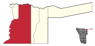
Kavango East is one of the fourteen regions of Namibia. Its capital is Rundu, its governor is Bonifatius Wakudumo. The region was created in 2013 when the Kavango Region was split into Kavango East and Kavango West. The only self-governing settlements in Kavango East are the capital Rundu and the village of Divundu.

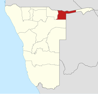
Kavango West is one of the fourteen regions of Namibia. Its capital and only self-governed settlement is Nkurenkuru, its governor is Sirkka Ausiku. The Region was created in 2013 when the Kavango Region was split into Kavango East and Kavango West. In the north, Kavango West borders the Cuando Cubango Province of Angola. Domestically, it borders the regions of Kavango East to the east, Otjozondjupa to the south, Oshikoto to the west and Ohangwena to the northwest.
Ncuncuni is a constituency in the Kavango West region of Namibia. It is located west of Rundu, one of Namibia's largest cities. It had a population of 38,281 in 2011, up from 26,623 in 2001. As of 2020 the constituency had 4,554 registered voters.
Poverty in Namibia is common with an unemployment rate of 29.9%, poverty incidence of 26.9% and HIV prevalence of 16.9%. Namibia has an economic growth rates averaging 4.3% according to the World Bank, and is one of nine nations in Africa classified by the World Bank as upper center pay. However, income disparity in the country is one of the world's highest with a Gini coefficient of 59.1 in 2015, and there were 3,300 US$ millionaires in 2017.
The First Division is the second-tier association football league in Namibia. It operates under the auspices of the Namibia Football Association.
References
- 1 2 "Index-Kings of Namibia". www.klausdierks.com. Retrieved 2024-08-02.
- 1 2 "Shambyu leader Queen Ribebe has died". The Namibian. 2015-06-15. Retrieved 2023-12-22.
- 1 2 "Hompa Sofia Mundjembwe Kanyetu Coronated". nbc. Retrieved 2023-12-22.