
Merstone railway station, was an intermediate station situated on the edge of Merstone village on the line from Newport to Sandown incorporated by the Isle of Wight Railway in 1868, opened in 1875 and closed 81 years later. In 1897 a new line opened from Merstone to provide an alternative route to the south-east corner of the island, running initially to St Lawrence and in 1900 to Ventnor West station. Located in the heart of a farming community, Merstone was snowed under during the harsh winter of 1947. The station building was demolished after closure, although the platform is still existent. Merstone station is now an access point onto National Cycle Route 23
Haseley Manor is a 14th-century, Grade 2* listed property located in Arreton on the Isle of Wight.

Morton Manor is a manor house originating in the 13th century, in Brading, Isle of Wight, England. It is located 1 mile (1.6 km) southwest of Sandown Road. The 14th century fairly small house was modified in the 19th century. Constructed of varied materials, it was refurbished and extended in the early 20th century in an Arts and Crafts style. A Tudor fireplace is in the dining room, with William De Morgan green glazed tiles. The manor includes a small museum of rural life.

Nunwell House, also Nunwell Manor, is a historic English country house in Brading, Isle of Wight. Located 3 miles (4.8 km) south of Ryde, the Tudor and Jacobean style house also has later additions. The house contains family militaria. It was occupied by the Oglander family from Norman times until 1980. Nunwell House is a Grade II* listed building.
Gatcombe House is a manor house in Gatcombe on the Isle of Wight, England. The original building was constructed by the Stur (Estur) family as noted in the Domesday Book. St. Olave's Church, built next to the manor to serve as its chapel, was dedicated in 1292. It also belonged at one time to the Lisles of Wootton.
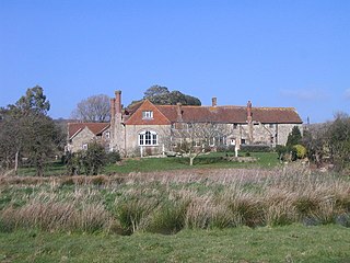
Steephill Manor is a British manor house on the Isle of Wight, situated within the Newchurch parish.
Billingham Manor is a manor house lying about a mile south of the village of Chillerton on the Isle of Wight.
Mirables is an English country house on the Isle of Wight in South East England. It was built by George Arnold of Ashby Lodge, Northamptonshire.

Wolverton Manor is a manor house in Shorwell, on the Isle of Wight, England. The original house was started by John Dingley, Deputy Governor of the Isle of Wight. The Jacobean style home, built by Sir John Hammond after the death of Sir John Dingley, is the second house built on the site. There is a two-storey porch which features a flat roof and hollow angle columns.

Northcourt Manor is one of three manor houses, along with Woolverton and Westcourt, that is located in Shorwell, on the Isle of Wight, England. It was begun by Sir John Leigh, Deputy Governor of the Island, in 1615, but was unfinished at his death. Northcourt is currently in use as a hotel.
Appley Towers, also called Appley Tower or Appley Tower House was an English country house near Appley House in Appley, Isle of Wight. It was the home of the Hutt family, who bought it in the 1870s, and later of Sir Hedworth Williamson. The house has been demolished, but a number of its estate buildings survive.
Appley House is an English country house and abbey in Appley Rise, Ryde, Isle of Wight.
Yaverland Manor is a medieval manor house in Yaverland, near Sandown, on the Isle of Wight. It was reconstructed in c. 1620 with alterations c. 1709. It became a Grade I listed building in 1949.

Standen House is an English country house located 1 mile (1.6 km) south of Newport, Isle of Wight. The 18th-century house has a brick front and features seven-bay windows, a porch with Doric columns, and triglyph frieze. Made of brick, it is located at the base of Pan Down. To its right is situated the park of Gatcombe, which itself lies in a valley which includes the winding River Medina. Gatcombe House lies opposite Standen House, separated by the river and woods. Great East Standen Manor is nearby.

Westcourt Manor is one of three manor houses, along with Woolverton and Northcourt, that is located in Shorwell, on the Isle of Wight, England. According to the Domesday Book, it was part of the possessions of Gozehne Fitz Azor, and had been held in the time of the Edward the Confessor by Ulnod in abeyance. At the time of the countess Isabella's record, we find that Sir John Lisle had this manor, with many others, which he held of her in capite, or by knight's service. It was possessed by Colonel Hill. An Elizabethan manor, it is connected to a farm of 200 acres.
Thorley Manor is a manor house just outside Yarmouth, on the Isle of Wight, England. Built in 1712, it features a modillion cornice, hipped roof, as well as tall chimneys.
Woolverton Manor is one of three manor houses, along with Northcourt Manor and Westcourt Manor, just outside Shorwell, on the Isle of Wight, England.
Landguard Manor is a manor house in Shanklin on the Isle of Wight, England. Mentioned in the Domesday Book, over the centuries it was home to numerous notable gentlemen. It is a Grade II listed building. One of the finest known portraits by Sir Thomas Lawrence, English portrait painter and president of the Royal Academy, is located in its drawing room.
Wode Manor was a manor house in the parish of Brading on the Isle of Wight.
Hill Manor is a manor house in the parish of Brading on the Isle of Wight.


