Related Research Articles

Brimham Rocks, once known as Brimham Crags, is a 183.9-hectare (454-acre) biological Site of Special Scientific Interest (SSSI) and Geological Conservation Review (GCR) site, 8 miles (13 km) north-west of Harrogate, North Yorkshire, England, on Brimham Moor in the Nidderdale Area of Outstanding Natural Beauty. The site, notified as SSSI in 1958, is an outcrop of Millstone Grit, with small areas of birch woodland and a large area of wet and dry heath.

Goonhilly Downs is a Site of Special Scientific Interest (SSSI) that forms a raised plateau in the central western area of the Lizard peninsula in southern Cornwall, England. It is one of 229 English national nature reserves designated by Natural England with an area of almost 1,270 hectares.
South Milton Ley is a 162,000 square metres wetland in the South Hams, Devon, England. It was notified as a Site of Special Scientific Interest in 1976. Part of the site is managed as a nature reserve by the Devon Birdwatching and Preservation Society.
Whitacre Heath is a small village in the North Warwickshire district of the county of Warwickshire in England. It is one of 'The Whitacres' - Whitacre Heath, Nether Whitacre and Over Whitacre. Whitacre Heath is actually the heath of Nether Whitacre and not a separate parish. Whitacre Heath is newer and of 19th-century origin. It stems from the early days of railways in the 1830s, and from later developments by Joseph Chamberlain and the Water Department of the City of Birmingham. The Stonebridge Railway was opened on 12 August 1839 to provide a link between the Birmingham and Derby Junction Railway and the London and Birmingham Railway at Hampton in Arden, via Stonebridge. The line became redundant in the 1930s and the track bed is now a footpath for walkers. There are Victorian brick buildings for the management of drinking water, at Whitacre water works, which were originally associated with public works by the City of Birmingham. The village is now largely residential and agricultural.
Acres Farm Meadow is a 4.2 hectare biological Site of Special Scientific Interest (SSSI) in Wiltshire, notified in 1989. It lies between the villages of Somerford Keynes and Minety. The SSSI is the former site of a mediaeval ridge and furrow system which lies on the Upper Jurassic Oxford Clay. The site is home to grasses, sedges and herbs. Trees such as oak, maple, English elm and hawthorn can be found in the hedgerows on the site, which provide nesting sites for lesser whitethroat, willow warbler, yellowhammer and bullfinch.

Langley Wood and Homan's Copse is a 219.28 hectare biological Site of Special Scientific Interest in Wiltshire, notified in 1985.

The Lee Valley Reservoir Chain is located in the Lee Valley, and comprises 13 reservoirs that supply drinking water to London.
The Bottoms is a Site of Special Scientific Interest in County Durham, England. It lies just south of the A181 road, roughly midway between the villages of Cassop and Wheatley Hill, some 10 km south-east of Durham city.

Hay-a-Park Gravel Pit is a Site of Special Scientific Interest, or SSSI, adjacent to the east side of the town of Knaresborough, North Yorkshire, England. Having been a disused and flooded quarry since the 1970s, it now consists of the large Hay-a-Park Lake and three smaller ponds, besides associated reedbeds, scrub, woodland and grassland. It was designated as a SSSI in 1995 because it supports a number of wintering birds, including a large flock of goosander. This site is "one of the most northerly inland breeding populations of reed warbler in Britain." Hay-a-Park was once part of a royal park, an early landowner being Edward II.

Quarry Moor is a Site of Special Scientific Interest, or SSSI, at the south edge of Ripon, North Yorkshire, England, and adjacent to the A61 road. It contains an outcrop of Magnesian Limestone, exposed by former quarrying. 255 million years ago this limestone was the peripheral sediment of a tropical sea. The land was donated in 1945 to the people of Ripon by the town's mayor, Alderman Thomas Fowler Spence, a varnish manufacturer. The land was notified as an SSSI in 1986 because its calcareous grassland supported a large diversity of plant species. The site features a Schedule 8 protected plant, thistle broomrape. The land is protected as a nature reserve, and it is also managed as a recreational area. Therefore, its calcareous grass area is fenced off for protection and study, but it also contains a car park, information signs, a children's play area, accessible paths, benches, and dog waste bins.
Farnham Mires is a Site of Special Scientific Interest, or SSSI, to the east of the village of Farnham, North Yorkshire, England. It consists of a spring-fed marshy fen or mire with reeds and sedge, and drier calcareous grassland containing a diverse range of flora. It has a history of poaching and fox hunting, but since the late 19th century, the attention of botanists has been drawn to its large variety of flowering plants. It has received some consideration on this account since 1944, and from 1954 it was designated SSSI status. This site has no facilities, and is not open to the public.

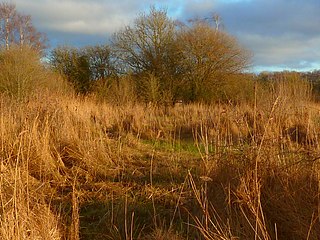
Cow Myers is a Site of Special Scientific Interest (SSSI) located in the Nidderdale Area of Outstanding Natural Beauty (AONB), near Ripon, North Yorkshire, England. The site was designated in 1984 for its fen and alder carr habitat, which supports a diversity of wetland plant life. Of particular interest are the bird's eye primrose which is scarce in Yorkshire, and early marsh orchid. There is no public access to this site, no vehicular access, and no public facilities.

Bishop Monkton Ings is a Site of Special Scientific Interest, or SSSI, situated east of Bishop Monkton village in North Yorkshire, England. It consists mostly of marshy, calcareous grassland, with some broadleaved woodland, and some fen alongside the two watercourses which run through the site. This varied wetland forms a habitat for a variety of plants, including the semi-parasitic marsh lousewort (Pedicularis palustris).

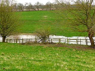
Mar Field Fen is a Site of Special Scientific Interest, or SSSI, north of Masham, North Yorkshire, England, in a rural area known as Marfield. It is situated on land containing woodland carr, fen, spring-fed marshy grassland and drier calcareous grassland, between the River Ure to the east and Marfield Wetland nature reserve to the west. As "one of the best examples of fen habitat in the Vale of York," it is a protected habitat for a variety of plants, including the common butterwort, a carnivorous plant. There is no public access to this site.

Hack Fall Wood, otherwise known as Hackfall, is a Site of Special Scientific Interest, or SSSI, of 44.8687 hectares, lying north-east of the village of Grewelthorpe, North Yorkshire, England. During the 18th century it was landscaped in the picturesque style by landowner William Aislabie, who created views by engineering streams and pools, planting trees and building follies. J. M. W. Turner and William Sawrey Gilpin painted it, and pictures of it featured on Catherine the Great's 1773 Wedgwood dinner service. Some 19th century writers called it "one of the most beautiful woods in the country."

Ripon Parks is a Site of Special Scientific Interest, or SSSI, situated north of Ripon, to the west of the River Ure and to the east of the village of North Stainley, in North Yorkshire, England. It was once part of the land held since the Middle Ages as a deer park by the archbishops of York and the canons of Ripon. The site was designated as an SSSI in 1983, because its varied habitats are valued for their breeding birds, amphibians and varied flora. The woods here are "of note" for the parasitic flowers of common toothwort and yellow star-of-Bethlehem. A small part of the site is accessible via public footpaths; there are no public facilities or dedicated car parks. The site incorporates the High Batts Nature Reserve, which is privately run for training, recording and educational purposes, and accessible to members only, except for its annual open day. Ripon Parks is now owned by the Ministry of Defence, and parts of the site are used as military training areas.
Kirk Deighton SSSI is a Site of Special Scientific Interest (SSSI) in Alton's Field, Kirk Deighton, North Yorkshire, England. This site has been recognised as having one of the largest known breeding populations of great crested newts in the United Kingdom. It is a Special Area of Conservation, and is listed for protection under a number of directives. This ordinary-looking grassland field, with a couple of ponds in it, is ideal habitat for the newts, which use the grassland for foraging, the ponds for breeding, and surrounding walls, hedges and woodpiles for hibernation. The site is not accessible to the public, and it is not permissible to survey the ponds without a licence.

Stonesfield Common, Bottoms and Banks is a 27.45-hectare (67.8-acre) biological Site of Special Scientific Interest (SSSI) south of Stonesfield in Oxfordshire.
References
- ↑ "Site units". designatedsites.naturalengland.org.uk. Retrieved 10 March 2022.
- ↑ "SSSI detail". designatedsites.naturalengland.org.uk. Retrieved 10 March 2022.