
Montgomery is a town in Franklin County, Vermont, United States. The population as of the 2020 census was 1,184. In 1963, part of Avery's Gore in Franklin County became part of Montgomery, with the other section becoming part of Belvidere in Lamoille County.

The Walloomsac River from the Native American name, Wal-loom-sac is a 16.8-mile-long (27.0 km) tributary of the Hoosic River in the northeastern United States. It rises in southwestern Vermont, in the Green Mountains east of the town of Bennington in Woodford Hollow at the confluence of Bolles Brook and City Stream where it is labeled Walloomsac Brook on maps but is locally known as "The Roaring Branch". The river then flows west toward Bennington and passes the downtown area to the north. For many years this section was intermittent due to the water having been diverted to power mills in town. This divergence gave the name Walloomsac to a portion of the river flowing through town on the present course of South Stream. The combined Walloomsac / South Stream joins the Roaring Branch northwest of town. From here the river flows westward as the Walloomsac River and joins the Hoosic River below Hoosick Falls, New York.

The Farmington River is a river, 46.7 miles (75.2 km) in length along its main stem, located in northwest Connecticut with major tributaries extending into southwest Massachusetts. The longest route of the river, from the origin of its West Branch, is 80.4 miles (129.4 km) long, making it the Connecticut River's longest tributary by 2.3 miles (3.7 km) over the Westfield River directly to its north. The Farmington River's watershed covers 609 square miles (1,580 km2). Historically, the river played an important role in small-scale manufacturing in towns along its course, but it is now mainly used for recreation and drinking water.

The Saxtons River is a 22.9-mile-long (36.9 km) river in the U.S. state of Vermont, a tributary of the Connecticut River. Its watershed covers 78 square miles (200 km2) and a range in altitude of 1,800 feet (550 m); land use is about 80% forested and 3% agricultural, and the upper river supports wild brook trout and brown trout, while Atlantic salmon occur but are usually limited to the area below Twin Falls on the lower river.

The Missisquoi River is a transboundary river of the east shore of Lake Champlain, approximately 80 miles (130 km) long, in northern Vermont in the United States and southern Quebec in Canada.

The Williams River is a 27.0-mile (43.5 km) river in the US state of Vermont. It is a tributary of the Connecticut River. Its watershed covers 117 square miles; land use is about 80% forested and 4% agricultural, and the upper river supports wild brook trout and brown trout.
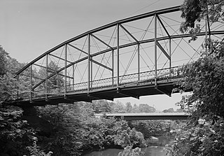
The Berlin Iron Bridge Company was a Berlin, Connecticut company that built iron bridges and buildings that were supported by iron. It is credited as the architect of numerous bridges and buildings now listed on the U.S. National Register of Historic Places. It eventually became part of the American Bridge Company.
The Hopkins Covered Bridge is a wooden covered bridge that crosses the Trout River in Enosburg, Vermont on Hopkins Bridge Road. Built in 1875 by brothers Sheldon & Savannah Jewett, it is one of a cluster of area covered bridges all attributed to the same builders. It was listed on the National Register of Historic Places in 1974.

The Comstock Covered Bridge is a wooden covered bridge that crosses the Trout River in Montgomery, Vermont on Comstock Bridge Road. Built in 1883, it is one of several area bridges built by Sheldon & Savannah Jewett. It was listed on the National Register of Historic Places in 1974.

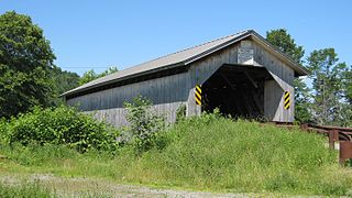
The West Hill Covered Bridge, also known as the Crystal Springs Covered Bridge is a wooden covered bridge that crosses West Hill Brook on Creamery Bridge Road in Montgomery, Vermont. It is one of six surviving 19th-century bridges built in Montgomery by the brothers Sheldon & Savannah Jewett. It was listed on the National Register of Historic Places in 1974.
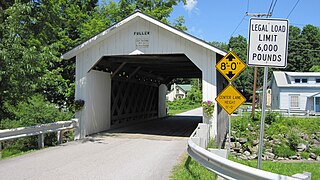
The Fuller Covered Bridge, also known as the Blackfalls Covered Bridge is a wooden covered bridge that crosses Black Falls Brook in Montgomery, Vermont on Fuller Bridge Road. It was listed on the National Register of Historic Places in 1974. The bridge is one of a concentrated regional collection built by brothers Sheldon & Savannah Jewett.

The Hutchins Covered Bridge is a wooden covered bridge that crosses the South Branch of the Trout River in Montgomery, Vermont on Hutchins Bridge Road. It was built in 1883 by Sheldon & Savannah Jewett, brothers who are credited with building most of the area's covered bridges. It was listed on the National Register of Historic Places in 1974.

The Longley Covered Bridge, also known as the Harnois Covered Bridge, is a wooden covered bridge that crosses the Trout River in Montgomery, Vermont on Longley Bridge Road. Built in 1863, this Town lattice truss bridge is the oldest of a group of area bridges built by brothers Sheldon & Savannah Jewett. It was listed on the National Register of Historic Places in 1974. The bridge is closed to traffic, and has been bypassed by an adjacent temporary bridge.

The Groton Bridge Co. was an American construction company, based in Groton, New York.

Vermont Route 104 (VT 104) is a state highway in the U.S. state of Vermont. The highway runs 20.503 miles (32.996 km) from VT 15 in Cambridge to VT 105 in the town of St. Albans. VT 104 is an L-shaped route that connects the city of St. Albans and Cambridge via Fairfax. The highway has an auxiliary route, VT 104A, that connects Fairfax and Georgia to the west.

Vermont Route 118 (VT 118) is a state highway in the U.S. state of Vermont. The highway runs 28.549 miles (45.945 km) from VT 100 in Eden north to VT 108 in Berkshire. VT 118 connects several towns in northern Lamoille County and eastern Franklin County, including the covered bridge–rich town of Montgomery. The town of Berkshire maintains the highway north of VT 105.

Best's Covered Bridge(akaSwallow's Bridge) is a historic covered bridge in West Windsor, Vermont, that carries Churchill Road over Mill Creek, just south of Vermont Route 44. Built in 1889, it is an architecturally distinctive laminated arch structure with a post-and-beam superstructure. It was listed on the National Register of Historic Places in 1973.

The Hectorville Covered Bridge is a historic covered bridge in Montgomery, Vermont. Originally located on Gibou Road off Vermont Route 118 in central Montgomery, the bridge is currently (2016) in storage. It was built by Sheldon & Savannah Jewett, who are credited with building all of Montgomery's surviving 19th century covered bridges. It was listed on the National Register of Historic Places in 1974.
The Trout River is a tributary of the Missisquoi River, flowing successively in municipalities of Montgomery, in Enosburg and in East Berkshire, in Franklin County, in northern Vermont in the United States.
The South Branch Trout River is a tributary of the Trout River, flowing successively in Belvidere and in Montgomery, in Lamoille County and in Franklin County, in northern Vermont in the United States.
