This article relies largely or entirely on a single source .(January 2021) |
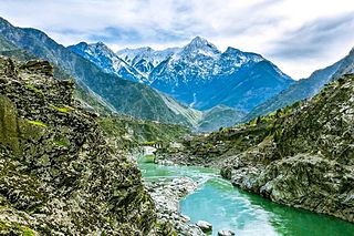
Shinkari is an area in Kohistan of the Indus Valley in the Hindu Kush mountains of Pakistan.
This article relies largely or entirely on a single source .(January 2021) |
Shinkari is an area in Kohistan of the Indus Valley in the Hindu Kush mountains of Pakistan.
There are high schools in both government and private sectors, such as the APS (army public school). Hazara University is located some 10 km away from the town of Shinkari.[ citation needed ]
The Karakoram Highway is the main route passing through the town of Shinkari. This road leads to the capital of the Federally Administered Northern Areas at Gilgit and to China via the path of the ancient Silk Highway.[ citation needed ]
The economy of the town relies on agriculture. Tea gardens and tobacco, wheat, maize and rice are cultivated in the fertile land of Pakhal.[ citation needed ]
Hindko and the Pushto are the local languages spoken in Shinkari.[ citation needed ]
The climate is mostly pleasant and maximum temperatures during summer are 30 C and minimum temperatures in winter are -4C. There is snowfall in winter.
The Kohistan of the Indus Valley, which is also called Shinkari, "the country of the Shins "by the people themselves is inhabited by what are apparently the remains of a number of tribes of cognate race, whose progenitors once inhabited the valleys skirting the Punjab, and possibly extended to the north and north west have been hitherto confounded under the name of Dards -a name which practically, has no real signification [1]

The ancient history of Afghanistan, also referred to as the pre-Islamic period of Afghanistan, dates back to the prehistoric era and the Helmand civilization around 3300–2350 BCE. Archaeological exploration began in Afghanistan in earnest after World War II and proceeded until the late 1970s during the Soviet–Afghan War. Archaeologists and historians suggest that humans were living in Afghanistan at least 50,000 years ago, and that farming communities of the region were among the earliest in the world. Urbanized culture has existed in the land from between 3000 and 2000 BC. Artifacts typical of the Paleolithic, Mesolithic, Neolithic, Bronze, and Iron ages have been found inside Afghanistan.

Khyber Pakhtunkhwa, formerly known as North West Frontier Province (NWFP), is a province of Pakistan. Located in the northwestern region of the country, Khyber Pakhtunkhwa is the fourth largest province of Pakistan by land area and the third-largest province by population. It is bordered by Balochistan to the south; Punjab, Islamabad Capital Territory, and Azad Kashmir to the east; and Gilgit-Baltistan to the north and northeast. It shares an international border with Afghanistan to the west. Khyber Pakhtunkhwa has a varied geography of rugged mountain ranges, valleys, rolling foothills, and dense agricultural farms.

The Geography of Pakistan encompasses a wide variety of landscapes varying from plains to deserts, forests, and plateaus ranging from the coastal areas of the Indian Ocean in the south to the mountains of the Karakoram, Hindukush, Himalayas ranges in the north. Pakistan geologically overlaps both with the Indian and the Eurasian tectonic plates where its Sindh and Punjab provinces lie on the north-western corner of the Indian plate while Balochistan and most of Khyber Pakhtunkhwa lie within the Eurasian plate which mainly comprises the Iranian Plateau.

The Himalayas, or Himalaya is a mountain range in Asia, separating the plains of the Indian subcontinent from the Tibetan Plateau. The range has several peaks exceeding an elevation of 8,000 m (26,000 ft) including Mount Everest, the highest mountain on Earth. The mountain range runs for 2,400 km (1,500 mi) as an arc from west-northwest to east-southeast at the northern end of the Indian subcontinent.

The Hindu Kush is an 800-kilometre-long (500 mi) mountain range in Central and South Asia to the west of the Himalayas. It stretches from central and eastern Afghanistan into northwestern Pakistan and far southeastern Tajikistan. The range forms the western section of the Hindu Kush Himalayan Region (HKH); to the north, near its northeastern end, the Hindu Kush buttresses the Pamir Mountains near the point where the borders of China, Pakistan and Afghanistan meet, after which it runs southwest through Pakistan and into Afghanistan near their border.

Swat District, also known as the Swat Valley, is a district in the Malakand Division of Khyber Pakhtunkhwa, Pakistan. Known for its stunning natural beauty, the district is a popular tourist destination. With a population of 2,687,384 per the 2023 national census, Swat is the 15th-largest district of Khyber Pakhtunkhwa.
Paropamisadae or Parapamisadae was a satrapy of the Alexandrian Empire in modern Afghanistan and Pakistan, which largely coincided with the Achaemenid province of Parupraesanna. It consisted of the districts of Sattagydia, Gandhara, and Oddiyana. Paruparaesanna is mentioned in the Akkadian language and Elamite language versions of the Behistun Inscription of Darius the Great, whereas in the Old Persian version it is called Gandāra. The entire satrapy was subsequently ceded by Seleucus I Nicator to Chandragupta Maurya following a treaty.

Northern Pakistan is a tourism region in northern and north-western parts of Pakistan, comprising the administrative units of Gilgit-Baltistan, Azad Kashmir, Khyber Pakhtunkhwa, Islamabad Capital Territory and the Rawalpindi Division in Punjab. The first two territories are a part of the wider Kashmir region. It is a mountainous region straddling the Himalayas, Karakoram and the Hindu Kush mountain ranges, containing many of the highest peaks in the world and some of the longest glaciers outside polar regions. Northern Pakistan accounts for a high level of Pakistan's tourism industry.
Kohistan District, also known as Indus Kohistan and Hazara Kohistan, was a former District within the Hazara Division of Khyber Pakhtunkhwa, Pakistan. Consisting of eastern portion of the larger Kohistan region, it was bifurcated into two districts in 2014: Upper Kohistan and Lower Kohistan. In 2017, the Lower Kohistan District was further bifurcated and a district Kolai-Palas was established. It has an area of 7,492 square kilometres (2,893 sq mi) and a population of 472,570 according to the 1998 Census.

Dir is a region in northwestern Pakistan in the Khyber Pakhtunkhwa, in the foothills of the Himalayas. Before the independence of Pakistan, Dir was a princely state, and it remained so until 1969 when it was abolished by a presidential declaration, and the Dir District was created the following year. The area covers 5,280 square kilometres. In 1996 Dir district was officially divided into Lower Dir District and Upper Dir District.

The Panjkora River is a river in the Khyber Pakhtunkhwa province in north-west Pakistan. The river runs through the mountainous northern part of the province, and forms the Kumrat Valley. It passes from Dir, Timergara, and joins with Swat River at Chakdara. It is generally characterized by steep slopes on either side of the riverbank covered in thick forests. The river has a large catchment area, making the river susceptible to significant flooding – most notably during the 2010 floods that occurred throughout much of Pakistan. It was named after Panjkora clan, a sub-clan in Mamyali section of Swati tribe which inhabited this region during 12 and 16 centuries and currently living in Hazara Division.

Dras, also known locally in Shina as Himababs, Hembabs, or Humas, is a town and hill station, and the headquarters of Drass district of the union territory of Ladakh in India. It is on the NH 1 between Zoji La pass and Kargil. A tourist hub for its high-altitude trekking routes and tourist sites, it is often called "The Gateway to Ladakh". The government's official spelling of the town's name is "Drass".
Battagram Tehsil is an administrative subdivision (Tehsil) of the Battagram District in the Khyber Pakhtunkhwa province of Pakistan. It serves as the Tehsil headquarters and covers a total area of 300 square miles (780 km2). Battagram Tehsil merged into Pakistan as an administrative region before being raised to the status of a district in 1993. On October 8, 2005, a 7.6 magnitude earthquake in Kashmir badly affected the area.

The Shina or Gilgitis are an Indo-Aryan ethnolinguistic group primarily residing in Gilgit–Baltistan and Indus Kohistan in Pakistan, as well as in the Dras Valley and Kishenganga Valley (Gurez) in the northern region of Jammu and Kashmir and Ladakh in India. They speak an Indo-Aryan language, called Shina and their geographic area of predominance is referred to as Shenaki.

Maini is the name of a village and a union council as well as a lush green physiographic valley with natural streams and fertile agricultural land which resides in Topi Tehsil in the eastern part of Swabi District of the province of Khyber Pakhtunkhwa in Pakistan. It has a very detailed historic profile, from the early historic age till the Partition of Pakistan. Maini lies at latitude 34°07'07.23" north and longitude 72°36'32.38" east with an elevation of about 383 meters above the sea level. Total area of Maini valley is about 5 kilometres from east to west and 6 kilometres from north to south.
The Katoor dynasty was a dynasty, which along with its collateral branches ruled the sovereign, later princely state of Chitral and its neighbours in the eastern Hindu Kush region for over 450 years, from around 1570 until 1947. At the height its power under Mehtar Aman ul-Mulk the territory controlled by the dynasty extended from Asmar in the Kunar Valley to Sher Qilla in the Gilgit valley. The Mehtar of Chitral was an influential player in the power politics of the region as he acted as an intermediary between the rulers of Badakhshan, the Yousafzai pashtuns, the Maharaja of Kashmir and later the Amir of Afghanistan.

The topography of Pakistan is divided into seven geographic areas: the northern highlands, the Indus River plain, the desert areas, the Pothohar Plateau, Balochistan Plateau, Salt Range, and the Sistan Basin. All the rivers of Pakistan, i.e. Sindh, Ravi River, Chenab River, Jhelum River, and Sutlej River, originate from the Himalayas mountain range. Some geographers designate Plateau as to the west of the imaginary southwest line; and the Indus Plain lies to the east of that line.
Teanaway is a small settlement in Kittitas County, Washington. It is located at the junction of State Route 10 and State Route 970. It is located east of Cle Elum and west of Ellensburg. The surrounding area is known as the Teanaway River Valley.

Indus Kohistanis are an Indo-Aryan ethnolinguistic group speaking the Indus Kohistani language. They mainly reside in Indus Kohistan, Hazara Division in northern Pakistan.
The Torwali people are an Indo-Aryan ethnolinguistic group located in the Swat district of Pakistan. The Torwali people have a culture that values the telling of folktales and music that is played using the sitar. They speak an Indo-Aryan language called Torwali.