Shirpala shelter

Last updated
Shirpala Shelter and Abshar Dogholu (Twin Falls) Shirpala Shelter.jpg
Shirpalā Shelter and Abshar Dogholu (Twin Falls)

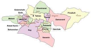
Shirpala shelter is a mountain shelter positioned in Alborz mountains, north of metropolitan Tehran, Iran.

Alborz mountain range

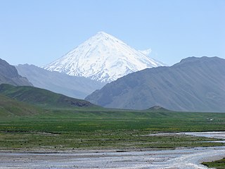
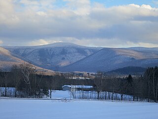
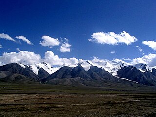
The Alborz, also spelled as Alburz, Elburz or Elborz, is a mountain range in northern Iran that stretches from the border of Azerbaijan along the western and entire southern coast of the Caspian Sea and finally runs northeast and merges into the Aladagh Mountains in the northern parts of Khorasan. This mountain range is divided into Western, Central, and Eastern Alborz Mountains. The Western Alborz Range runs south-southeastward almost along the western coast of the Caspian Sea. The Central Alborz runs from west to east along the entire southern coast of the Caspian Sea, while the Eastern Alborz runs in a northeasterly direction towards the northern parts of the Khorasan region southeast of the Caspian Sea. Mount Damavand, the highest mountain in Iran measuring 5,610.0 m, is located in the Central Alborz Mountains.

Tehran City in Iran

Tehran is the capital of Iran and Tehran Province. With a population of around 8.694 million in the city and 15 million in the larger metropolitan area of Greater Tehran, Tehran is the most populous city in Iran and Western Asia, and has the second-largest metropolitan area in the Middle East. It is ranked 29th in the world by the population of its metropolitan area.

Iran Country in Western Asia

Iran, also called Persia and officially known as the Islamic Republic of Iran, is a country in Western Asia. With over 81 million inhabitants, Iran is the world's 18th most populous country. Comprising a land area of 1,648,195 km2 (636,372 sq mi), it is the second largest country in the Middle East and the 17th largest in the world. Iran is bordered to the northwest by Armenia and the Republic of Azerbaijan, to the north by the Caspian Sea, to the northeast by Turkmenistan, to the east by Afghanistan and Pakistan, to the south by the Persian Gulf and the Gulf of Oman, and to the west by Turkey and Iraq. The country's central location in Eurasia and Western Asia, and its proximity to the Strait of Hormuz, give it geostrategic importance. Tehran is the country's capital and largest city, as well as its leading economic and cultural center.

Contents

It is situated at the elevation of 2750 meters above sea level and is accessible via a route passing through Sarband, Pas-Ghaleh and Abshar Dogholu. It usually takes 3 to 4 hours to ascend to mount Tochal from this shelter. This shelter was made by Iranian Mountain Climbing Federation with the help of Iranian Boy Scout Association. [1] The shelter has some basic facilities such as restaurants, snack bars, few private rooms and two public dormitories.

Abshar Dogholu

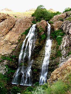
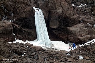
Abshar Dogholu or Dogholu Waterfalls, is the waterfall in the northern part of Tehran, Iran, and is located near Shirpala shelter positioned in the south face of mount Tochal in the Alborz mountains.

Tochal mountain

Tochal is a mountain and ski resort located on the Alborz mountain range, adjacent to the metropolitan area of Tehran in northern Iran. It includes a 12-kilometre-long (7.5 mi) ridge. Its highest peak, also called Tochal, is at an elevation of 3,964 metres (13,005 ft).

Shirpala's southern view at sunset Sunset shirpala.jpg
Shirpala's southern view at sunset

Folklore

It is believed that Kai Kobad, mythical Iranian king had lived in a fort located in Shirpala before ascending to the throne with the help of Rostam another Iranian mythical figure. [2]

Rostam hero in Iranian mythology

Rostam or Rustam, son of Zal and Rudaba, is the most celebrated legendary hero in Shahnameh and Iranian mythology. In Shahnameh, Rostam and his predecessors are Marzbans of Sistan. Rostam is best known for his tragic fight with Esfandiar; the other legendary Iranian hero, for his expedition to Mazandaran ; and for tragically fighting and killing his son, Sohrab, without knowing who his opponent is. Rostam was eventually killed by Shaghad, his half-brother.

See also

Related Research Articles

Mount Washington (New Hampshire) highest mountain in the US state of New Hampshire

Mount Washington, called Agiocochook by some Native American tribes, is the highest peak in the Northeastern United States at 6,288.2 ft (1,916.6 m) and the most topographically prominent mountain east of the Mississippi River.

Mount Greylock mountain in Massachusetts

Mount Greylock is a 3489 foot mountain located in the northwest corner of Massachusetts, the highest point in the state. Its summit is in the western part of the town of Adams in Berkshire County. Although technically it is geologically part of the Taconic Mountains, Mount Greylock is commonly associated with the abutting Berkshire Mountains to the east. The mountain is known for its expansive views encompassing five states and the only taiga-boreal forest in the state. A seasonal automobile road climbs to the summit, topped by a 93-foot-high (28 m) lighthouse-like Massachusetts Veterans War Memorial Tower. A network of hiking trails traverse the mountain, including the Appalachian Trail. Mount Greylock State Reservation was created in 1898 as Massachusetts' first public land for the purpose of forest preservation.

Kunlun Mountains mountain range in China

The Kunlun Mountains are one of the longest mountain chains in Asia, extending more than 3,000 kilometres (1,900 mi). In the broadest sense, the chain forms the northern edge of the Tibetan Plateau south of the Tarim Basin.

Mount Damavand potentially active volcano or Stratovolcano and the highest peak in Iran

Mount Damavand, a potentially active volcano, is a stratovolcano which is the highest peak in Iran and the highest volcano in Asia; the Kunlun Volcanic Group in Tibet is higher than Damāvand, but are not considered to be volcanic mountains. Damāvand has a special place in Persian mythology and folklore. It is in the middle of the Alborz range, adjacent to Varārū, Sesang, Gol-e Zard, and Mīānrūd. It is near the southern coast of the Caspian Sea, in Amol County, Mazandaran Province, 66 kilometres northeast of the city of Tehran.

Mellat Park

Mellat Park, literally the Nation Park, is an urban park in northern Tehran, Iran.

Darband, formerly a village close to Tajrish, Shemiran, is a neighborhood inside Tehran's metropolitan limits. It is the beginning of a popular hiking trail into Mount Tochal, which towers over Tehran. A chairlift is also available for those not interested in hiking.

The Anti-Taurus Mountains are a mountain range in southern and eastern Turkey, curving northeast from the Taurus Mountains. The tallest mountain in the range is Mount Erciyes, 12,851 feet (3,917 m) high. The ancient Greek geographer Strabo wrote that in his time the summit was never free from snow, and that those few who ascended it could see both the Black Sea and the Mediterranean.

Velenjak is an affluent neighbourhood, northwest of Tehran, in Iran. Velenjak is located in the Shemiran area in the northernmost part of Tehran, on the slopes of the Alborz mountain range. It is known for its landscapes, mild climate, mountain air, springs, and wildlife and is one of the most expensive neighborhoods in Tehran.

Lar Dam

Lar Dam is a dam located at the foot of Mount Damavand in Amol county, Mazandaran, Iran. The dam is located within the protected Lar National Park and situated just 70 kilometers northeast of the capital and the most populous city of the country, Tehran. The primary purpose of the dam is municipal water supply to Tehran but prior to the water reaching the city filtration plant, it is used to power the Kalan and Lavarak Hydroelectric Power Stations, with a combined installed capacity of 162.5 MW.

Huayin County-level city in Shaanxi, Peoples Republic of China

Huayin is a county-level city in Weinan, Shaanxi province, China. Prior to 1990, Huayin had been regarded as a county. Huayin literally means to the north of Mount Hua, because it is situated to the north of that mountain.

Qods County County in Tehran, Iran

Qods County is a county in Tehran Province in Iran. The capital of the county is Qods. At the 2006 census, the county's population was 237,077, in 62,355 families. The county has one district: the Central District. The county has one city: Qods.

Kan Creek is a stream of water flowing through Western Tehran.

Lar National Park

Lar National Park is a protected area in Mazandaran Province and Tehran Province, in northern Iran.

Aidin Bozorgi Iranian mountain climber

Aidin Bozorgi was an Iranian mountain climber. He was 13 years old when he started mountaineering. Soon, he had shown how talented he was by climbing Mount Damavand when he was only 15 years old. Bozorgi was good at most mountain-relating climbing sports such as ice climbing, mixed climbing, rock climbing, sport climbing, big wall climbing, traditional climbing, aid climbing and bouldering.

Mian Darreh is a village in Khvosh Rud Rural District, Bandpey-ye Gharbi District, Babol County, Mazandaran Province, Iran. At the 2006 census, its population was 195, in 52 families.

Mount Castleguard mountain in Canada

Mount Castleguard is an isolated mountain located near the southern edge of the Columbia Icefield at the northern edge of Banff National Park in Alberta, Canada. In 1918, Irish land surveyor Arthur Oliver Wheeler named the mountain because of its castle-like appearance, which seemed to stand guard over the southern portion of the Columbia Icefield. Mount Castleguard was first ascended in 1919 by the Interprovincial Boundary Commission, which determined the exact location of the boundary between British Columbia and Alberta along the continental divide.

Yakhi Waterfall

Yakhi Waterfall or Abshar Yakhi, is the waterfall in Amol, Iran, and is located near the southern part of Mount Damavand.

References

  1. A.Soltani. "Mount Tochal | damawand.de". www.damawand.de. Retrieved 2016-06-26.
  2. "کوهستان - شیرپلا (دژ کیقباد)". koooohestan.blogfa.com. Retrieved 2016-06-26.

Coordinates: 35°51′18″N51°25′46″E / 35.8550°N 51.4294°E / 35.8550; 51.4294

Geographic coordinate system Coordinate system

A geographic coordinate system is a coordinate system that enables every location on Earth to be specified by a set of numbers, letters or symbols. The coordinates are often chosen such that one of the numbers represents a vertical position and two or three of the numbers represent a horizontal position; alternatively, a geographic position may be expressed in a combined three-dimensional Cartesian vector. A common choice of coordinates is latitude, longitude and elevation. To specify a location on a plane requires a map projection.