Related Research Articles

Hawke Bay, formerly named Hawke's Bay, is a large bay on the east coast of the North Island of New Zealand, surrounded by the Hawke's Bay region. It stretches from Māhia Peninsula in the northeast to Cape Kidnappers / Te Kauwae-a-Māui in the southwest, a distance of some 90 kilometres (56 mi).

Central Hawke's Bay District is in the Hawke's Bay Region in the North Island of New Zealand. Formed in 1989, it covers an area of 3,333 square kilometres, from Pukehou in the north to Takapau in the south, and from the western Ruahine Range to the Pacific coast in the east. It has a population of 16,000, up from 14,142 in the 2018 census and 12,717 in the 2013 census.

Te Waewae Bay is the westernmost of three large bays lying on the Foveaux Strait coast of Southland, New Zealand, the others being Oreti Beach and Toetoes Bay. Twenty-seven kilometres in length, the western end of the bay is mountainous, with the southern terminus of the Southern Alps and Fiordland National Park.
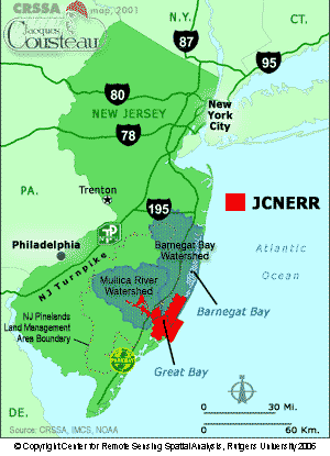
The Jacques Cousteau National Estuarine Research Reserve, located in southeastern New Jersey, encompasses over 110,000 acres (450 km2) of terrestrial, wetland and aquatic habitats within the Mullica River-Great Bay Ecosystem.

Waipātiki Beach is a small coastal village in the Hastings District and Hawke's Bay Region of New Zealand's North Island. It is situated in a little valley at the end of a road that branches off the main road from Napier to Gisborne and that finally, after 11 km, leads to a small sandy beach; first Tangoio Rd, then Waipātiki Road.

Asilomar State Marine Reserve (SMR) is one of four small marine protected areas (MPAs) located near the cities of Monterey and Pacific Grove, at the southern end of Monterey Bay on California’s central coast. The four MPAs together encompass 2.96 square miles (7.7 km2). The SMR protects all marine life within its boundaries. Fishing and take of all living marine resources is prohibited.

Natural Bridges State Marine Reserve (SMR) is a marine protected area located at the northern edge of Santa Cruz, California, approximately 75 miles (121 km) south of San Francisco. The SMR covers 0.58 square miles (1.5 km2). The SMR protects all marine life within its boundaries. Fishing or other removal of any living marine resource is prohibited.

Lovers Point State Marine Reserve (SMR) is one of four small marine protected areas located near the cities of Monterey and Pacific Grove, at the southern end of Monterey Bay on California’s central coast. The four MPAs together encompass 2.96 square miles (7.7 km2). The SMR protects all marine life within its boundaries. Fishing and take of all living marine resources is prohibited.

Pacific Grove Marine Gardens State Marine Conservation Area is one of four small marine protected areas located near the cities of Monterey and Pacific Grove, at the southern end of Monterey Bay on California’s central coast. The four MPAs together encompass 2.96 square miles (7.7 km2). Within the SMCA fishing and take of all living marine resources is prohibited except the recreational take of finfish and the commercial take of giant and bull kelp by hand under certain conditions. According to the Frommer's guide, the Marine Gardens area is "renowned for ocean views, flowers, and tide-pool seaweed beds."

Cape Rodney-Okakari Point Marine Reserve is a 5.5 km2 (2.1 sq mi) protected area in the North Island of New Zealand. All fishing, and the removal or disturbing of marine life or materials, is forbidden within the reserve.

San Diego-Scripps Coastal Marine Conservation Area (SMCA) and Matlahuayl State Marine Reserve (SMR) are adjoining marine protected areas that extend offshore from La Jolla in San Diego County on California's south coast. The two marine protected areas cover 2.51 square miles (6.5 km2).
Clifton is a coastal beach reserve motor camp in Hawke's Bay, New Zealand. It is located eighteen kilometres southeast of the city centre of Napier and eight kilometres west of the tip of Cape Kidnappers. Clifton marks the start of the walk or ride around to the Cape Kidnappers gannet colony.
Blackhead is a small coastal settlement in Hawke's Bay, New Zealand. It is located on the east coast of the North Island of New Zealand, about 74 kilometres south of Napier. Blackhead Beach is a sandy beach, similar to other Hawke's Bay beaches such as Shoal Beach. The original Māori name for the beach is Te Pariomahu and this is more commonly used by local hapū.

Crystal Cove State Marine Conservation Area (SMCA) is one of a cluster of four adjoining marine protected areas that extend offshore of Newport Beach in Orange County on California’s south coast. The SMCA covers 3.45 square miles of near shore waters. Crystal Cove protects marine life by limiting the removal of marine wildlife from within its borders, including tide pools. Take of all living marine resources is prohibited except: recreational take of finfish by hook-and-line or by spearfishing, and lobster and sea urchin is allowed. Commercial take of coastal pelagic species by round haul net, spiny lobster by trap, and sea urchin is allowed.
Upper Newport Bay State Marine Conservation Area (SMCA) is a marine protected area in Newport Bay in Orange County and the South Coast region of Southern California. It extends inland/northeast from the Pacific Coast Highway crossing of the bay, within the city of Newport Beach.

Te Matuku Marine Reserve is a marine reserve administered by the New Zealand Department of Conservation. It includes Te Matuku Bay, one of the largest and least disturbed estuaries on Waiheke Island, as well as a surrounding area of sea. It covers an area of 690 ha and was established in 2003.
Te Matuku Bay is a bay on Waiheke Island in New Zealand's Hauraki Gulf. It is one of the largest and least disturbed estuaries on the island. Since 2003, the area has been protected as part of Te Matuku Marine Reserve.

Tauparikākā Marine Reserve is a marine reserve located offshore about 20 kilometres (12 mi) north of Haast on the West Coast of New Zealand's South Island. It covers the area immediately offshore from Ship Creek, which is also known as Tauparikākā in Māori.
Te Angiangi Marine Reserve is a marine reserve covering a marine area of 446 hectares in the Hawke's Bay Region of New Zealand's North Island. It was established in 1997 and is administered by the Department of Conservation.

Taumoana Marine Reserve is a marine reserve covering an area of 464 hectares in Fiordland on New Zealand's South Island. It was established in 2005 and is administered by the Department of Conservation. It is located next to the Five Fingers Peninsula, at the entrance to Tamatea / Dusky Sound.
References
- ↑ "Shoal Beach — Aramoana Historic Woolshed". Archived from the original on 2012-04-26. Retrieved 2011-12-27.
- ↑ "Shoal Beach — te Angiangi Marine Reserve". Archived from the original on 2012-04-26. Retrieved 2011-12-30.