
Schoolcraft County is a county located in the Upper Peninsula of the U.S. state of Michigan. As of the 2010 United States Census, the population was 8,485. The county seat is Manistique, which lies along the northern shore of Lake Michigan. The county is named in honor of Henry Schoolcraft, who explored the area with the expedition of Lewis Cass. The county was founded in 1843 and organized in 1876. The county is largely rural and forested, with much of its western portion within Hiawatha National Forest.

Whitefish Township is a civil township of Chippewa County in the U.S. state of Michigan. The population was 575 at the 2010 census.

Germfask Township is a civil township of Schoolcraft County in the U.S. state of Michigan. The population was 491 at the 2000 census.

Manistique, formerly Monistique, is the only incorporated city in and the county seat of Schoolcraft County of the U.S. state of Michigan's Upper Peninsula. As of the 2010 census, the city population was 3,097. The city lies on the north shore of Lake Michigan, adjacent the southwest corner of Manistique Township. Manistique was founded where the Manistique River flows into Lake Michigan, forming a kind of natural harbor, which has since been improved with breakwaters, dredging, and a lighthouse. The city takes its name from the Manistique River. The economy also depends heavily on tourism.

Hiawatha National Forest is a 894,836-acre (362,127 ha) National Forest in the Upper Peninsula of the state of Michigan in the United States. Commercial logging is conducted in some areas. The United States Forest Service administers this National Forest; it is physically divided into two subunits, commonly called the Eastside 46°14′N84°50′W and Westside 46°08′N86°40′W. In descending order of land area it lies in parts of Chippewa, Delta, Mackinac, Alger, Schoolcraft, and Marquette counties. Chippewa and Mackinac counties are in the Eastside, whereas the rest are in the Westside. The smaller Eastside contains about 44% of the forest's area, whereas the larger Westside has about 56%. Forest headquarters are located in Escanaba, Michigan. Eastside ranger district offices are located in Sault Ste. Marie and St. Ignace, while Westside offices are in Manistique, Munising, and Rapid River.
Gull Island is the name of a dozen small islands in the U.S. state of Michigan.
Carp River is a 40.2-mile-long (64.7 km) river in Chippewa and Mackinac counties in the U.S. state of Michigan. 21.7 miles (34.9 km) of the river were added to the National Wild and Scenic Rivers System in 1992.
Black River is an 11.0-mile-long (17.7 km) river on the Upper Peninsula of the U.S. state of Michigan. The river flows into Lake Michigan at 46°05′37″N85°20′30″W, approximately 5 miles (8 km) east of Naubinway.
The Shelldrake River is a 32-mile-long (51 km) river in Chippewa County on the Upper Peninsula of Michigan in the United States. It flows through Tahquamenon Falls State Park and the Lake Superior State Forest into Lake Superior.
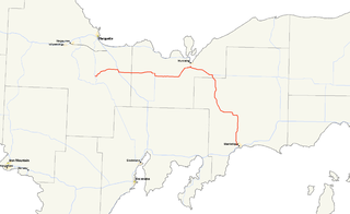
M-94 is a state trunkline in the Upper Peninsula of the US state of Michigan. It runs for 86.983 miles (139.986 km) from K. I. Sawyer to Manistique. The highway is part of the Lake Superior Circle Tour during a concurrency with M-28. M-94 crosses the Siphon Bridge in Manistique, unique for the fact that the bridge roadway is below water level.

The Presque Isle River runs 42.1 miles (67.8 km) through the Upper Peninsula of Michigan and empties into Lake Superior. Along its course, it flows through the Ottawa National Forest and Porcupine Mountains Wilderness State Park. It has 300 square miles (780 km2) of drainage area in Upper Michigan and northern Wisconsin.

The Betsie River is a 54.0-mile-long (86.9 km) stream in the northwest part of the U.S. state of Michigan. The name is derived from the French la rivière aux Bec-scies, meaning river of sawbill ducks (bec-scie). Other alternate names include Aug-sig-o-sebe, Aux Buscies, Betsey's River, Black Robe, Gay-she-say-ing, Riviere du Pere Marquette, Sawbill Ducks, and Shelldrake Ducks. The river is mostly within Benzie County, although the river rises in southwest Grand Traverse County and flows briefly through northern Manistee County, Michigan.
The Driggs River is a 36.2-mile-long (58.3 km) tributary of the Manistique River on the Upper Peninsula of Michigan in the United States.
The Peshekee River is a 31.1-mile-long (50.1 km) river on the Upper Peninsula of Michigan in the United States. It is a tributary of Lake Michigamme, and its waters flow via the Michigamme River and the Menominee River to Lake Michigan.
The Rock River is a 13.4-mile-long (21.6 km) river on the Upper Peninsula of Michigan in the United States, flowing to Lake Michigan.

Indian River is a 59.1-mile-long (95.1 km) tributary of the Manistique River on the Upper Peninsula of Michigan in the United States. It rises out of Hovey Lake at 46°17′36″N86°42′20″W on Hiawatha National Forest land in Alger County and flows south and east through a lake district and on through Schoolcraft County. The river flows into the 8,659 acre (35 km²) Indian Lake at 46°17′36″N86°42′20″W and flows out at 45°59′30″N86°17′15″W. It then flows east and south about 2.5 miles where it merges with the Manistique River, which then flows through Manistique and into Lake Michigan at 45°56′56″N86°14′45″W.

Lakefield Township is a civil township of Luce County in the U.S. state of Michigan. The population was 1,074 at the 2000 census.
There are three Manistique Lakes in the Upper Peninsula of Michigan. The lakes include North Manistique Lake, Big Manistique Lake, and South Manistique Lake. The towns surrounding the lakes are Curtis Township, Germfask, and Helmer. The lakes are known for vacationing and fishing. They are also in close proximity to other natural sights such as the Great Lakes, rivers, and smaller lakes as well as tourist attractions including the Canada–US border, the Soo Locks, Mackinac Island, parks, and museums.
West Branch Manistique River is a river in the Upper Peninsula of the U.S. state of Michigan. It rises in Alger County, flows southeast into Schoolcraft County, and discharges into the Manistique River. Its principal tributary is the Creighton River. Much of the river's course flows through wetlands that are a part of the Lake Superior State Forest, a semi-protected land area. Despite the name of the state forest, the waters of the West Branch ultimately flow into Lake Michigan.


