This article relies largely or entirely on a single source .(March 2024) |
Sicuani | |
---|---|
Town | |
![]() | |
Coordinates: 14°16′19″S71°13′44″W / 14.272°S 71.229°W | |
Country | ![]() |
Region | Cusco |
Province | Canchis |
District | Sicuani |
Government | |
• Mayor | Jorge Quispe Ccallo |
Time zone | UTC-5 (PET) |
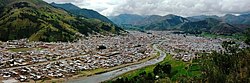
Sicuani is a town in southern Peru, capital of Canchis Province in Cusco Region. It has an estimated population of 54,672 inhabitants. One important feature in this town is the Urubamba River. The river was of great importance in the Inca Empire and previous cultures. Downstream, the Urubamba makes its way to the Amazon River.
Climate data for Sicuani, elevation 3,534 m (11,594 ft), (1991–2020) | |||||||||||||
---|---|---|---|---|---|---|---|---|---|---|---|---|---|
Month | Jan | Feb | Mar | Apr | May | Jun | Jul | Aug | Sep | Oct | Nov | Dec | Year |
Mean daily maximum °C (°F) | 18.8 (65.8) | 18.7 (65.7) | 19.1 (66.4) | 19.5 (67.1) | 19.5 (67.1) | 19.1 (66.4) | 18.9 (66.0) | 20.0 (68.0) | 20.8 (69.4) | 20.8 (69.4) | 21.0 (69.8) | 19.7 (67.5) | 19.7 (67.4) |
Mean daily minimum °C (°F) | 6.2 (43.2) | 6.2 (43.2) | 5.7 (42.3) | 3.5 (38.3) | −0.6 (30.9) | −3.2 (26.2) | −3.5 (25.7) | −1.6 (29.1) | 1.7 (35.1) | 3.9 (39.0) | 4.6 (40.3) | 5.5 (41.9) | 2.4 (36.3) |
Average precipitation mm (inches) | 135.6 (5.34) | 140.2 (5.52) | 109.6 (4.31) | 51.2 (2.02) | 10.5 (0.41) | 2.4 (0.09) | 3.9 (0.15) | 6.4 (0.25) | 17.7 (0.70) | 53.0 (2.09) | 75.2 (2.96) | 106.4 (4.19) | 712.1 (28.03) |
Source: National Meteorology and Hydrology Service of Peru [1] |