Related Research Articles

The Pennines, also known as the Pennine Chain or Pennine Hills, are a range of uplands mainly located in Northern England. Commonly described as the "backbone of England" because of its length and position, the range runs from Derbyshire and Staffordshire in the North Midlands to Northumberland in North East England, near the Anglo-Scottish border. The range starts near the valley of the River Trent to the south and extends northwards across the Peak District, South Pennines, Yorkshire Dales, and North Pennines, ending at the Tyne Gap. Beyond the gap are the Border Moors and Cheviot Hills, which are included in some definitions of the range.

The Yorkshire Dales are a series of valleys, or dales, in the Pennines, a range of hills in England. They are mostly located in the ceremonial county of North Yorkshire, but extend into Cumbria and Lancashire; they were historically entirely within Yorkshire. The majority of the dales are within the Yorkshire Dales National Park, created in 1954. The exception is the area around Nidderdale, which forms the separate Nidderdale Area of Outstanding Natural Beauty.

Pen-y-ghent or Penyghent is a fell in the Yorkshire Dales, England. It is the lowest of Yorkshire's Three Peaks at 2,277 feet (694 m); the other two being Ingleborough and Whernside. It lies 1.9 miles (3 km) east of Horton in Ribblesdale. It has a number of interesting geological features, such as Hunt Pot, and further down, Hull Pot. The waters that flow in have created an extensive cave system which rises at Brants Gill head.

Gaping Gill is a natural cave in North Yorkshire, England. It is one of the unmistakable landmarks on the southern slopes of Ingleborough – a 98-metre (322 ft) deep pothole with the stream Fell Beck flowing into it. After falling through one of the largest known underground chambers in Britain, the water disappears into the bouldery floor and eventually resurges adjacent to Ingleborough Cave.

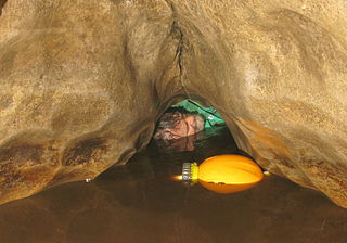
The Cave Diving Group (CDG) is a United Kingdom-based diver training organisation specialising in cave diving.

The Ease Gill Cave System is the longest, and most complex cave system in Britain as of 2011, with around 41 miles (66 km) of passages, including connections only passable by cave diving. It spans the valley between Leck Fell and Casterton Fell. The water resurges into Leck Beck.

Carboniferous Limestone is a collective term for the succession of limestones occurring widely throughout Great Britain and Ireland that were deposited during the Dinantian Epoch of the Carboniferous Period. These rocks formed between 363 and 325 million years ago. Within England and Wales, the entire limestone succession, which includes subordinate mudstones and some thin sandstones, is known as the Carboniferous Limestone Supergroup.

The Geology of Yorkshire in northern England shows a very close relationship between the major topographical areas and the geological period in which their rocks were formed. The rocks of the Pennine chain of hills in the west are of Carboniferous origin whilst those of the central vale are Permo-Triassic. The North York Moors in the north-east of the county are Jurassic in age while the Yorkshire Wolds to the south east are Cretaceous chalk uplands. The plain of Holderness and the Humberhead levels both owe their present form to the Quaternary ice ages. The strata become gradually younger from west to east.

Leck Fell is a Site of Special Scientific Interest in Lancashire, England. An area of typically heavily grazed open moorland of rough grass and remnant patches of heather with little or no tree cover, it is characterised by the virtual absence of surface drainage and an extensive subterranean drainage network resulting in cave systems and numerous sinkholes. It surrounds the high point of Gragareth 627 metres (2,057 ft) between Leck Beck and Kingsdale.
Francis Graham Balcombe was a pioneer of cave diving in the United Kingdom and a founder of the Cave Diving Group together with Jack Sheppard.
The Nidderdale Caves are a series of caves in Upper Nidderdale in North Yorkshire, England. There are two cave systems and most of the caves are in some way linked with one or the other. The smaller system is the Eglin cave system in the valley of How Stean Beck, a tributary of the River Nidd, associated with How Stean Gorge. The larger system is the Goyden cave system under the valley of the River Nidd, which flows east from Scar House Reservoir, then south, and shortly after disappears underground down several sink holes to reappear at the rising just beyond the village of Lofthouse. Cavers are able to access several sections of this system via the different entrances.

Short Drop Cave and Gavel Pot are different entrances into the same cave system on Leck Fell, in Lancashire, England. The main top entrance, Short Drop Cave, is a small hole in a fenced off shakehole near the main stream sink; Gavel Pot, a window into the system, is a large fenced shakehole some 40-metre (130 ft) deep requiring tackle to descend. There are two other smaller entrances into Short Drop Cave. At its base the system links via a sump with Lost Johns' Cave, and is part of the Three Counties System, an 87 kilometres (54 mi) cave system which spans the borders of Cumbria, Lancashire, and North Yorkshire.
Disappointment Pot is one of the entrances to the Gaping Gill cave system, located in a steep grassy shakehole some 120 metres (130 yd) south-east of Gaping Gill Main Shaft. Its mainly narrow stream passage descends a number of small shafts to enter the main system as a major inlet of Hensler's Master Cave. It lies within the designated Ingleborough Site of Special Scientific Interest.
Stream Passage Pot is one of the entrances to the Gaping Gill system being located about 320 metres (350 yd) ESE of Gaping Gill Main Shaft. It is a popular and sporting entrance into the system, featuring three well-watered big shafts. It is the highest entrance of the Gaping Gill system, so the full depth of the system, 198 metres (650 ft), is measured from its entrance. It lies within the designated Ingleborough Site of Special Scientific Interest.
Flood Entrance Pot is one of the entrances to the Gaping Gill cave system located about 300 metres (330 yd) south of Gaping Gill Main Shaft. It was the first alternative entrance into the main system to be explored, and it is now a popular entrance into the system, with a fine 38-metre (125 ft) pitch landing in Gaping Gill's South-East Passage. It lies within the designated Ingleborough Site of Special Scientific Interest.

Weathercote Cave is a natural solutional cave in Chapel-le-Dale, North Yorkshire, England. It has been renowned as a natural curiosity since the eighteenth century, and was accessible to paying visitors until 1971. The entrance is a large shaft about 20 metres (66 ft) deep, dominated by a waterfall entering at one end. It lies within the designated Ingleborough Site of Special Scientific Interest.

The Three Counties System is a set of inter-connected limestone solutional cave systems spanning the borders of Cumbria, Lancashire and North Yorkshire in the north of England. The possibility of connecting a number of discrete cave systems in the area to create a single super-system that spans the county borders was first proposed by Dave Brook in 1968, and it was achieved in 2011. The system is currently over 86 kilometres (53 mi) long, making it the longest in the UK and the thirtieth longest in the world, and there continues to be scope for considerably extending the system.

The Long Kin East Cave - Rift Pot system is a limestone cave system on the southern flanks of Ingleborough, North Yorkshire in England lying within the designated Ingleborough Site of Special Scientific Interest. Long Kin East Cave starts as a long meandering stream passage but then plummets down a 58-metre (190 ft) deep shaft when it meets a shattered fault into which Rift Pot also descends. At the bottom, the stream flows through some low canals and sumps, to eventually emerge at Austwick Beck Head in Crummackdale.
References
- 1 2 3 4 Taylor, M. R. (1999). Dark life: Martian nanobacteria, rock-eating cave bugs, and other extreme organisms of inner earth and outer space. Simon and Schuster. ISBN 0684841916.
- 1 2 Toksvig, Sandi (9 October 2004). "Caves". BBC. BBC. Retrieved 7 July 2018.
- ↑ Eavis, Andy (13 October 2017). "The golden age of cave exploration". Geographical. Syon Geographical Ltd. Retrieved 7 July 2018.
- 1 2 3 "The Sid Perou Story". Wild Places Publishing and Descent Magazine. Wild Places Publishing. Retrieved 7 July 2018.
- 1 2 3 Gunn, J. (2004). Encyclopedia of caves and karst science. Taylor & Francis. ISBN 1135455082.
- 1 2 3 4 5 Martin Baines (director) (27 February 2018). The Sid Perou Story (Motion picture).
- 1 2 Fawcett, Ron (2011). Ron Fawcett - Rock Athlete: The Story of a Climbing Legend. Vertebrate Publishing. ISBN 1906148392.
- 1 2 3 4 "The Sid Perou Video Collection". British Caving Library. British Cave Research Association. Retrieved 7 July 2018.
- ↑ "Sid Perou--Awards". IMDb. IMDb.com, Inc. Retrieved 7 July 2018.
- ↑ "Sid Perou: The Lost River of Gaping Gill - Breakthrough". British Caving Library. British Cave Research Association. Retrieved 8 July 2018.
- ↑ "Beneath the Pennines". BBC. BBC. 30 November 1978. Retrieved 8 July 2018.
- ↑ "Sid Perou: Beneath the Pennines - Dow Cave". British Caving Library. British Cave Research Association. Retrieved 8 July 2018.
- ↑ "Sidney Perou". MyHeritage. MyHeritage Ltd. Retrieved 9 July 2018.
- 1 2 "Sid Perou". BFI. British Film Institute. Retrieved 7 July 2018.[ dead link ]