
The M4, originally the London-South Wales Motorway, is a motorway in the United Kingdom running from west London to southwest Wales. The English section to the Severn Bridge was constructed between 1961 and 1971; the Welsh element was largely complete by 1980, though a non-motorway section around Briton Ferry bridge remained until 1993. On the opening of the Second Severn Crossing in 1996, the M4 was rerouted over it.

The A12 is a major road in Eastern England. It runs north-east/south-west between London and the coastal town of Lowestoft in the north-eastern corner of Suffolk, following a similar route to the Great Eastern Main Line until Ipswich. A section of the road between Lowestoft and Great Yarmouth became part of the A47 in 2017. Between the junctions with the M25 and the A14, the A12 forms part of the unsigned Euroroute E30. Unlike most A roads, this section of the A12, together with the A14 and the A55, has junction numbers as if it were a motorway.
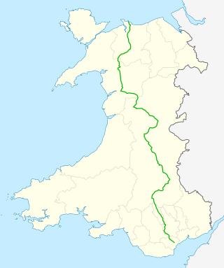
The A470 is a trunk road in Wales. It is the country's longest road at 186 miles (299 km) and links the capital Cardiff on the south coast to Llandudno on the north coast. While previously one had to navigate the narrow roads of Llanidloes and Dolgellau, both these market towns are now bypassed due to extensive road modernisation. The 26 miles (42 km) from Cardiff Bay to Merthyr Tydfil are mainly dual carriageway, but most of the route from north of Merthyr to Llandudno is single carriageway.

A trunk road, trunk highway, or strategic road is a major road, usually connecting two or more cities, ports, airports and other places, which is the recommended route for long-distance and freight traffic. Many trunk roads have segregated lanes in a dual carriageway, or are of motorway standard.

The Grand Trunk Road is one of Asia's oldest and longest major roads. For at least 2,500 years it has linked Central Asia to the Indian subcontinent. It runs roughly 2,400 km (1,491 mi) from Teknaf, Bangladesh on the border with Myanmar west to Kabul, Afghanistan, passing through Chittagong and Dhaka in Bangladesh, Kolkata, Kanpur, Delhi, Amritsar in India, and Lahore, Gujrat, Rawalpindi, and Peshawar in Pakistan.
The A580 is the United Kingdom's first purpose-built inter-city highway. The road, which remains a primary A road, was officially opened by King George V on 18 July 1934. It links Liverpool to Salford, 3 miles (4.8 km) west of Manchester city centre.

The A458 is a route on the UK highway network that runs from Mallwyd, near Machynlleth, in Wales, merging with the A456 Hagley Road and the Quinton Expressway on the outskirts of Birmingham, in England. On the way it passes through Welshpool, Shrewsbury, Much Wenlock, Bridgnorth, Stourbridge and Halesowen

Road surface marking is any kind of device or material that is used on a road surface in order to convey official information; they are commonly placed with road marking machines. They can also be applied in other facilities used by vehicles to mark parking spaces or designate areas for other uses. In some countries and areas, road markings are conceived as horizontal traffic signs, as opposed to vertical traffic signs placed on posts.

The A6055 is a 25-mile (40 km) stretch of road in North Yorkshire that runs from Knaresborough to Boroughbridge, with a break, then starts up again at Junction 50 of the A1(M) to run parallel with A1(M) acting as a Local Access Road (LAR) going between Junction 50 and 56 at Barton. Responsibility for the route rests with the Highways Agency, as it is designated as a primary route associated with the A1(M) upgrade.

The A494 is a trunk road in Wales and England. The route, which is officially known as the Dolgellau to South of Birkenhead Trunk Road, runs between the terminus of the M56 motorway between Mollington and Capenhurst and the A470 at Dolgellau, Gwynedd. Its northern sections remain among the busiest roads in Wales.
The United Kingdom has a well developed and extensive network of roads totalling about 262,300 miles (422,100 km). Road distances are shown in miles or yards and UK speed limits are indicated in miles per hour (mph) or by the use of the national speed limit (NSL) symbol. Some vehicle categories have various lower maximum limits enforced by speed limiters. A unified numbering system is in place for Great Britain, whilst in Northern Ireland, there is no available explanation for the allocation of road numbers.

The Highways Act 1980 (c.66) is an act of the Parliament of the United Kingdom dealing with the management and operation of the road network in England and Wales. It consolidated with amendments several earlier pieces of legislation. Many amendments relate only to changes of highway authority, to include new unitary councils and national parks. By virtue of the Local Government (Wales) Act 1994 and the Environment Act 1995, most references to local authority are taken to also include Welsh councils and national park authorities.

The PC800 Pacific Coast is a touring motorcycle manufactured and marketed by Honda between 1989 and 1998. Named after California's Pacific Coast Highway, over 14,000 were sold in North America, Europe and Japan, with a three-year hiatus between two production runs. The bike is noted for its single integrated trunk straddling the rear wheel, full bodywork, and distinctive two-tone paint.

The A629 road is an inter-Yorkshire road that runs from Skipton to Rotherham through Keighley, Halifax, Huddersfield and Chapeltown in Yorkshire, England. The road runs through North, West and South Yorkshire, but before 1974, the entire length of the road was wholly within the boundaries of the West Riding of Yorkshire. It is designated as a primary route through most of its length.

Kings Transit Authority is a public transit agency operating buses in the Annapolis Valley, Nova Scotia. The system, incorporated in 1981, is funded by Kings County, Annapolis County, Digby County and the towns of Berwick, Wolfville, Kentville, Middleton, Annapolis Royal, and Digby.

The A174 is a major road in North Yorkshire, England. It runs from the A19 road at Thornaby-on-Tees, across South Teesside and down the Yorkshire Coast to Whitby. The A174 is the coastal route between Teesside and Whitby; the alternative road, the A171, is described as being the moorland route.

The A479, officially also known as the Glanusk Park (Crickhowell)—Llyswen Trunk Road, is a trunk road in Wales. It connects Crickhowell to Llyswen via the Rhiangoll valley and Talgarth, running through the Brecon Beacons National Park.

Trunk roads in Wales were created in the Trunk Roads Act of 1936 when the UK Ministry of Transport took direct control over 30 of the principal roads in Great Britain from English, Welsh and Scottish local authorities. The number of trunk roads was increased from 30 to 101 in the Trunk Roads Act of 1946. These roads formed what the Act called "the national system of routes for through traffic". Since Welsh devolution the trunk road system in Wales has been managed by the South Wales Trunk Road Agent and the North and Mid Wales Trunk Road Agent on behalf of the Welsh Government. As of April 2019, out of a total of 34,850 miles (56,090 km) of roads in Wales, 1,576 miles (2,536 km) are trunk roads.

Welsh Government traffic officers are civilian staff employed by the trunk road agents on behalf of the Welsh Government as a means to ease traffic congestion on major trunk roads in Wales. Their role and powers are similar to their English counterparts working for National Highways, the National Highways traffic officers.