Rhineland-Palatinate is a western state of Germany. It covers 19,846 km2 (7,663 sq mi) and has about 4.05 million residents. It is the ninth largest and sixth most populous of the sixteen states. Mainz is the capital and largest city. Other cities are Ludwigshafen am Rhein, Koblenz, Trier, Kaiserslautern, Worms and Neuwied. It is bordered by North Rhine-Westphalia, Saarland, Baden-Württemberg and Hesse and by France, Luxembourg and Belgium.

Westphalia is a region of northwestern Germany and one of the three historic parts of the state of North Rhine-Westphalia. It has an area of 20,210 square kilometres (7,800 sq mi) and 7.9 million inhabitants.

The Rhineland is a loosely defined area of Western Germany along the Rhine, chiefly its middle section.
The Westerwald is a low mountain range on the right bank of the river Rhine in the German federal states of Rhineland-Palatinate, Hesse and North Rhine-Westphalia. It is a part of the Rhenish Massif. Its highest elevation, at 657 m above sea level, is the Fuchskaute in the High Westerwald.
Siegen-Wittgenstein is a Kreis (district) in the southeast of North Rhine-Westphalia, Germany. Neighboring districts are Olpe, Hochsauerlandkreis, Waldeck-Frankenberg, Marburg-Biedenkopf, Lahn-Dill, Westerwaldkreis, and Altenkirchen.
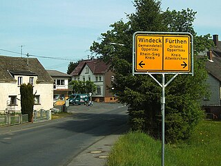
Altenkirchen is a district in Rhineland-Palatinate, Germany. It is bounded by the North Rhine-Westphalian districts Rhein-Sieg, Oberbergischer Kreis, Olpe and Siegen-Wittgenstein, and the districts of Westerwaldkreis and Neuwied.

The Sieg is a river in North Rhine-Westphalia and Rhineland-Palatinate, Germany. It is a right tributary of the Rhine.

Siegen is a city in Germany, in the south Westphalian part of North Rhine-Westphalia.

Kreuztal is a town in the Siegen-Wittgenstein district, in North Rhine-Westphalia, Germany.

Netphen is a town in the Siegen-Wittgenstein district, in North Rhine-Westphalia, Germany. It lies on the river Sieg, roughly 7 km northeast of Siegen.
Nassau-Siegen was a principality within the Holy Roman Empire that existed between 1303 and 1328, and again from 1606 to 1743. From 1626 to 1734, it was subdivided into Catholic and Protestant parts. Its capital was the city of Siegen, founded in 1224 and initially a condominium jointly owned by the archbishopric of Cologne and Nassau. It was located some 50 km east of Cologne, and it contained the modern localities of Freudenberg, Hilchenbach, Kreuztal, Siegen, and Wilnsdorf.

Liebenscheid is an Ortsgemeinde – a community belonging to a Verbandsgemeinde – in the Westerwaldkreis in Rhineland-Palatinate, Germany.

Burbach is a municipality in the Siegen-Wittgenstein district, in North Rhine-Westphalia, Germany.
Alte Burg, Alteburg or Burgstall Alte Burg refers to the name or nickname of various castles, castle ruins, castle sites and hillforts or ringworks:

The Trödelsteine is the name of a mountain, 613 m above sea level (NHN), in the Heller Upland near Emmerzhausen in the county of Altenkirchen in the German state of Rhineland-Palatinate and in the county of Siegen-Wittgenstein in the state of North Rhine-Westphalia with its summit area in Rhineland-Palatinate.
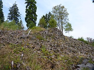
The Trödelsteine, also called the Trödelstein, is a rock formation near Emmerzhausen in the county of Altenkirchen in the German state of Rhineland-Palatinate. It consists of columnar basalt and a basaltic blockfield in the Heller Upland. The rock formation has been designated as a natural monument, about 0.3 hectares in area.

Siegerland-Höhenring(Siegerland mountain ridge circular route) is an approximately 142-kilometre-long (88-mile-long) hiking trail in Germany that circles most parts of Siegerland in the districts of Siegen-Wittgenstein and Altenkirchen.