External links
| Authority control databases: People |
|---|
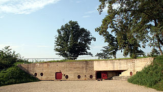
The Siegfried Line Museum (German : Westwallmuseum Irrel) lies near the German-Luxembourg border in the Eifel mountains. It is housed in a bunker that was part of the former Siegfried Line (Westwall), the Katzenkopf Strongpoint (Panzerwerk Katzenkopf), which was built from 1937 to 1939. The bunker and museum lies within the municipality of Irrel and have been open to visitors since 1979. Together with other bunkers the Panzerwerk Katzenkopf was built to guard the main road from Cologne to the city of Luxembourg. It is the northernmost strongpoint in the Siegfried Line.
These strongpoints differed from the other roughly 15,000 fortifications of the Siegfried Line in having an armoured cupola and wall thicknesses of at least 1.0 metre. 32 examples of such structures were built to construction thickness "B" with exterior walls of reinforced concrete up to 2 metres thick. Another of these so called B-Werke ("B Works") that has been open to the public since 2006 is B-Werk Besseringen in the Saarland.
The above-ground section of the bunder was blown up in 1947 and its remains were bulldozed into a heap. In July 1976 the excavation of the bunker began the majority of the work being carried out by the Volunteer Fire Service of Irrel. The Siegfried Line Museum has been established on 3 accessible levels of the strongpoint since 1979. There are pictures and weapons of the Second World War period. The museum is only open to casual visitors on Sundays and public holidays (during the summer).
| Authority control databases: People |
|---|

The Siegfried Line, known in German as the Westwall, was a German defensive line built during the late 1930s. Started in 1936, opposite the French Maginot Line, it stretched more than 630 km (390 mi) from Kleve on the border with the Netherlands, along the western border of Nazi Germany, to the town of Weil am Rhein on the border with Switzerland. The line featured more than 18,000 bunkers, tunnels and tank traps.
The Bar-Lev Line was a chain of fortifications built by Israel along the eastern bank of the Suez Canal shortly after the 1967 Arab–Israeli War, during which Egypt lost the entire Sinai Peninsula. It was considered impenetrable by the Israeli military until it was overrun in less than two hours during Egypt's Operation Badr, which sparked the 1973 Arab–Israeli War.
La Coupole, also known as the Coupole d'Helfaut-Wizernes and originally codenamed Bauvorhaben 21 or Schotterwerk Nordwest, is a Second World War bunker complex in the Pas-de-Calais department of northern France, about 5 kilometres (3.1 mi) from Saint-Omer, and some 14.4 kilometers south-southeast from the less developed Blockhaus d'Éperlecques V-2 launch installation in the same area. It was built by the forces of Nazi Germany between 1943 and 1944 to serve as a launch base for V-2 rockets directed against London and southern England and is the earliest known precursor to modern underground missile silos still in existence.

Hanstholm is a small town and a former island, now elevated area in Thisted municipality of Region Nordjylland, located in northern Denmark. The population of the town is 2,085.

Fort Tourgis is an extensive fortification in Alderney to the north west of St Anne forming part of the Fortifications of Alderney.
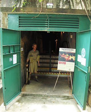
The Battle Box is the popular name of the Fort Canning Bunker, formerly known as Headquarters Malaya Command Operations Bunker, constructed under Fort Canning Hill, Singapore, as an emergency, bomb-proof command centre during the Malayan Campaign and the Battle of Singapore. The Battle Box is currently a museum and tourist attraction.

Wittlich is a town in Rhineland-Palatinate, in western Germany, the seat of the Bernkastel-Wittlich district. Its historic town centre and the beauty of the surrounding countryside make the town a centre for tourism in southwest Germany.

The Valentin submarine factory is a protective shelter on the Weser River at the Bremen suburb of Rekum, built to protect German U-boats during World War II. The factory was under construction from 1943 to March 1945 using forced labour, but was damaged by air-raids and unfinished by the end of the war. The Valentin factory was the largest fortified U-boat facility in Germany, and was second only to those built at Brest in France.

The Government Bunker(Regierungsbunker) in Germany, officially named Ausweichsitz der Verfassungsorgane des Bundes im Krisen- und Verteidigungsfall zur Wahrung von deren Funktionstüchtigkeit (AdVB), in English: "Emergency Seat of the Federal Constitutional Organs for the State of Crisis or State of Defence to Maintain their Ability to Function" was a massive underground complex built during the Cold War era to house the German government, parliament and enough federal personnel needed to keep the government working in the event of war or severe crisis. Located only about 25 kilometres (16 mi) south of Bonn, Germany, in the Ahr Valley between the towns of Ahrweiler and Dernau, it was one of the best kept secrets of West Germany. It was built between 1960 and 1972 inside two abandoned railway tunnels that were built as part of the Strategic Railway, maintained and kept in a working condition for about 30 years and decommissioned in 1997. A small part of the once-secret site is now open to the public as Government Bunker Documentation Site, while the vast majority is abandoned and sealed.

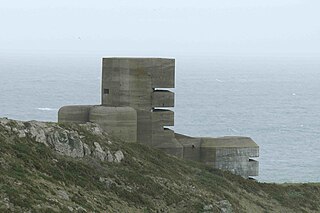
The Fort Hommet 10.5 cm coastal defence gun casemate bunker is a fully restored gun casemate that was part of Fortress Guernsey constructed by the forces of Nazi Germany between 1940 and 1945.
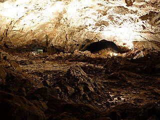
The Heimkehle is one of two great gypsum caves in Germany that are accessible as show caves. It lies on the southern edge of the Harz Mountains between Rottleberode and Uftrungen, east of Nordhausen, right on the state border between Thuringia and Saxony-Anhalt. The cave may be visited as part of a 45-minute-long guided tour.

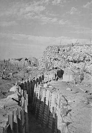
A pillbox is a type of blockhouse, or concrete dug-in guard-post, often camouflaged, normally equipped with loopholes through which defenders can fire weapons. It is in effect a trench firing step, hardened to protect against small-arms fire and grenades, and raised to improve the field of fire.

Fort Hommet is a fortification on Vazon Bay headland in Castel, Guernsey. It is built on the site of fortifications that date back to 1680 and consists of a Martello tower from 1804, later additions during the Victorian Era, and bunkers and casemates that the Germans constructed during World War II.

The Regelbau were a series of standardised bunker designs built in large numbers by the Germans in the Siegfried Line and the Atlantic Wall as part of their defensive fortifications prior to and during the Second World War.
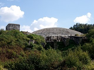
The B-Werk near Besseringen is the only completely preserved fortification built to construction standard "B" in the Siegfried Line. It is part of the so-called Saar position and lies within the borough of the German town of Merzig.
The Orscholz Switch, or Siegfried Switch, was a military defensive "switch" position and part of the Siegfried Line (Westwall) located in the triangle between the rivers Saar and Moselle. It was built in 1939 and 1940 and incorporated 75 bunkers as well as 10.2 km of tank obstacles in the form of dragon's teeth. This defensive line ran from Trier to Nennig along the Moselle and from Nennig in an easterly direction to Orscholz on the loop in the Saar river at Mettlach.
Although the West Wall in this sector lay behind the Saar, the Germans in 1939 and 1940 had constructed a supplementary fortified line across the base of the triangle from Nennig in the west to Orscholz, at a great northwestward loop of the Saar. The Germans called the position the Orscholz Switch; the Americans knew it as the Siegfried Switch. Assuming the neutrality of Luxembourg, the switch position was designed to protect Trier and the Moselle corridor and to prevent outflanking of the strongest portion of the West Wall, that lying to the southeast across the face of the Saar industrial area.
After the Wehrmacht occupied the Channel Islands on 30 June 1940, they assessed the existing defences to determine if they would be of use. The Germans found the Islands' fortifications antiquated and woefully inadequate for modern warfare.

The flexible defense is a military theory about the design of modern fortifications. The examples of "flexible" defense-lines are not based on dense lines of heavily armed, large and expensive concrete fortifications as the systems such as the Maginot Line were. Their protective capacity hinges on multiple lines of obstacles and small shelters fitting into the environment. They are "flexible" because soldiers are not locked in pillboxes, but fight instead in easily replaceable open earth-wood made positions, while bunkers serve only as shelters during bombardments. As a result, they are able to adapt to the opponent's movements, and there are no easily targeted large buildings in these lines.

On 15 July 1949 an ammunition depot exploded on the hill of Kalvarienberg in the Eifel mountains, in western Germany near the border with Luxembourg. The cause of the explosion, in which the town of Prüm was heavily damaged and 12 people killed, was never discovered. The crater, which is still visible today, is one of the largest man-made explosion craters in existence. A cross on the Kalvarienberg commemorates the victims of the disaster.