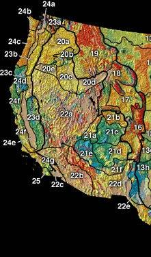
The Sierra Nevada is a mountain range in the Western United States, between the Central Valley of California and the Great Basin. The vast majority of the range lies in the state of California, although the Carson Range spur lies primarily in Nevada. The Sierra Nevada is part of the American Cordillera, an almost continuous chain of mountain ranges that forms the western "backbone" of the Americas.

Dew is water in the form of droplets that appears on thin, exposed objects in the morning or evening due to condensation.

Fog is a visible aerosol consisting of tiny water droplets or ice crystals suspended in the air at or near the Earth's surface. Fog can be considered a type of low-lying cloud usually resembling stratus, and is heavily influenced by nearby bodies of water, topography, and wind conditions. In turn, fog affects many human activities, such as shipping, travel, and warfare.
Orography is the study of the topographic relief of mountains, and can more broadly include hills, and any part of a region's elevated terrain. Orography falls within the broader discipline of geomorphology. The term orography comes from the Greek: όρος, hill, γραφία, to write.
In the context of physical geography, the Intermontane Plateaus is one of eight physiographic regions of the contiguous United States. The region consists mostly of plateaus and mountain ranges lying between the Rocky Mountains on the east and the Cascade and Sierra Nevada Mountains on the west. It is subdivided into three physiographic provinces: the Columbia Plateau in the north, the Basin and Range Province in the central and southwestern portions, and the Colorado Plateau in the southeast. In turn, each of these provinces are each subdivided into a number of physiographic sections.

The lapse rate is the rate at which an atmospheric variable, normally temperature in Earth's atmosphere, falls with altitude. Lapse rate arises from the word lapse, in the sense of a gradual fall. In dry air, the adiabatic lapse rate is 9.8 °C/km. The saturated air lapse rate (SALR), or moist adiabatic lapse rate (MALR), is the decrease in temperature of a parcel of water-saturated air that rises in the atmosphere. It varies with the temperature and pressure of the parcel and is often in the range 3.6 to 9.2 °C/km, as obtained from the International Civil Aviation Organization (ICAO). The environmental lapse rate is the decrease in temperature of air with altitude for a specific time and place. It can be highly variable between circumstances.

A mushroom cloud is a distinctive mushroom-shaped flammagenitus cloud of debris, smoke, and usually condensed water vapor resulting from a large explosion. The effect is most commonly associated with a nuclear explosion, but any sufficiently energetic detonation or deflagration will produce the same effect. They can be caused by powerful conventional weapons, like thermobaric weapons such as the ATBIP and GBU-43/B MOAB. Some volcanic eruptions and impact events can produce natural mushroom clouds.

In meteorology, precipitation is any product of the condensation of atmospheric water vapor that falls from clouds due to gravitational pull. The main forms of precipitation include drizzle, rain, sleet, snow, ice pellets, graupel and hail. Precipitation occurs when a portion of the atmosphere becomes saturated with water vapor, so that the water condenses and "precipitates" or falls. Thus, fog and mist are not precipitation but colloids, because the water vapor does not condense sufficiently to precipitate. Two processes, possibly acting together, can lead to air becoming saturated: cooling the air or adding water vapor to the air. Precipitation forms as smaller droplets coalesce via collision with other rain drops or ice crystals within a cloud. Short, intense periods of rain in scattered locations are called showers.

Magdalena is a department of Colombia with more than 1.3 million people, located to the north of the country by the Caribbean Sea. The capital of the Magdalena Department is Santa Marta and was named after the Magdalena River. It inherited the name of one of the original nine states of the United States of Colombia that its current territory integrated.

Orographic lift occurs when an air mass is forced from a low elevation to a higher elevation as it moves over rising terrain. As the air mass gains altitude it quickly cools down adiabatically, which can raise the relative humidity to 100% and create clouds and, under the right conditions, precipitation.

A rain shadow is an area of significantly reduced rainfall behind a mountainous region, on the side facing away from prevailing winds, known as its leeward side.
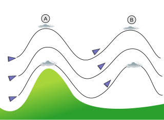
In meteorology, lee waves are atmospheric stationary waves. The most common form is mountain waves, which are atmospheric internal gravity waves. These were discovered in 1933 by two German glider pilots, Hans Deutschmann and Wolf Hirth, above the Giant Mountains. They are periodic changes of atmospheric pressure, temperature and orthometric height in a current of air caused by vertical displacement, for example orographic lift when the wind blows over a mountain or mountain range. They can also be caused by the surface wind blowing over an escarpment or plateau, or even by upper winds deflected over a thermal updraft or cloud street.

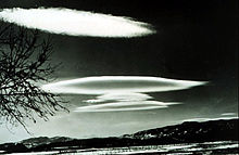
Lenticular clouds are stationary clouds that form mostly in the troposphere, typically in parallel alignment to the wind direction. They are often comparable in appearance to a lens or saucer. Nacreous clouds that form in the lower stratosphere sometimes have lenticular shapes.

Cloud physics is the study of the physical processes that lead to the formation, growth and precipitation of atmospheric clouds. These aerosols are found in the troposphere, stratosphere, and mesosphere, which collectively make up the greatest part of the homosphere. Clouds consist of microscopic droplets of liquid water, tiny crystals of ice, or both, along with microscopic particles of dust, smoke, or other matter, known as condensation nuclei. Cloud droplets initially form by the condensation of water vapor onto condensation nuclei when the supersaturation of air exceeds a critical value according to Köhler theory. Cloud condensation nuclei are necessary for cloud droplets formation because of the Kelvin effect, which describes the change in saturation vapor pressure due to a curved surface. At small radii, the amount of supersaturation needed for condensation to occur is so large, that it does not happen naturally. Raoult's law describes how the vapor pressure is dependent on the amount of solute in a solution. At high concentrations, when the cloud droplets are small, the supersaturation required is smaller than without the presence of a nucleus.

In meteorology, prevailing wind in a region of the Earth's surface is a surface wind that blows predominantly from a particular direction. The dominant winds are the trends in direction of wind with the highest speed over a particular point on the Earth's surface at any given time. A region's prevailing and dominant winds are the result of global patterns of movement in the Earth's atmosphere. In general, winds are predominantly easterly at low latitudes globally. In the mid-latitudes, westerly winds are dominant, and their strength is largely determined by the polar cyclone. In areas where winds tend to be light, the sea breeze/land breeze cycle is the most important cause of the prevailing wind; in areas which have variable terrain, mountain and valley breezes dominate the wind pattern. Highly elevated surfaces can induce a thermal low, which then augments the environmental wind flow.
The Wegener–Bergeron–Findeisen process, is a process of ice crystal growth that occurs in mixed phase clouds in regions where the ambient vapor pressure falls between the saturation vapor pressure over water and the lower saturation vapor pressure over ice. This is a subsaturated environment for liquid water but a supersaturated environment for ice resulting in rapid evaporation of liquid water and rapid ice crystal growth through vapor deposition. If the number density of ice is small compared to liquid water, the ice crystals can grow large enough to fall out of the cloud, melting into rain drops if lower level temperatures are warm enough.
A wave cloud is a cloud form created by atmospheric internal waves.
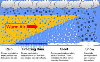
In meteorology, the different types of precipitation often include the character, formation, or phase of the precipitation which is falling to ground level. There are three distinct ways that precipitation can occur. Convective precipitation is generally more intense, and of shorter duration, than stratiform precipitation. Orographic precipitation occurs when moist air is forced upwards over rising terrain and condenses on the slope, such as a mountain.

Montane ecosystems are found on the slopes of mountains. The alpine climate in these regions strongly affects the ecosystem because temperatures fall as elevation increases, causing the ecosystem to stratify. This stratification is a crucial factor in shaping plant community, biodiversity, metabolic processes and ecosystem dynamics for montane ecosystems. Dense montane forests are common at moderate elevations, due to moderate temperatures and high rainfall. At higher elevations, the climate is harsher, with lower temperatures and higher winds, preventing the growth of trees and causing the plant community to transition to montane grasslands and shrublands or alpine tundra. Due to the unique climate conditions of montane ecosystems, they contain increased numbers of endemic species. Montane ecosystems also exhibit variation in ecosystem services, which include carbon storage and water supply.
This glossary of meteorology is a list of terms and concepts relevant to meteorology and atmospheric science, their sub-disciplines, and related fields.