Sigsbee Deep

Last updated

The Sigsbee Deep [Note 1] (Mexico basin in the U. S. Board on Geographic Names Advisory Committee on Undersea Features Gazetteer) [1] is a roughly triangular basin that is the deepest part of the Gulf of Mexico named for Charles Dwight Sigsbee. [2] There is some confusion of names that apply to the basin or a particular point in the basin, with both being found in technical and popular literature applying to both basin and the coordinates.

Contents

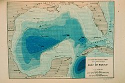
Contour map of Gulf of Mexico as sounded by the C&GS Steamer Blake between 1873 and 1875. Over 3,000 soundings went into this chart, most of the deep water soundings taken by the Sigsbee Sounding Machine. This was the first realistic bathymetric map of any oceanic basin. In: "Three Cruises of the BLAKE" by Alexander Agassiz, 1888. P. 102. Contour map of Gulf of Mexico 1888.jpg
Contour map of Gulf of Mexico as sounded by the C&GS Steamer Blake between 1873 and 1875. Over 3,000 soundings went into this chart, most of the deep water soundings taken by the Sigsbee Sounding Machine. This was the first realistic bathymetric map of any oceanic basin. In: "Three Cruises of the BLAKE" by Alexander Agassiz, 1888. P. 102.

Description

The basin is located in the southwestern quadrant of the gulf, with its closest point to the U.S. coast at 200 miles (320 km) southeast of Brownsville, Texas. [3] The actual maximum depth is disputed, and estimates range between 3,750 and 4,384 metres (12,303 and 14,383 ft). The average depth of the gulf is roughly 1,615 metres (5,299 ft). [3] The Sigsbee Abyssal Plain is the deepest and flattest sector of the deep basin. [1]

Name/Location differences

The use of "Sigsbee" for the feature originates from Commander Charles Dwight Sigsbee's Gulf of Mexico surveys that defined the general features of the body while he was commanding officer of the USC&GS George S. Blake. "Sigsbee Deep" applied to the entire deep basin appears on some of the earliest charts of the Gulf of Mexico.

Sigsbee Deep is a variant name for the United States Board on Geographic Names (BGN) approved name of Mexico Basin for cartographic materials produced by federal agencies. [4] A proposal by the United States renaming Sigsbee Deep, with coordinates of 23° 52′ N 91° 35′ W, to "Mexico Basin" was rejected by the Sixteenth Meeting of the GEBCO Subcommittee on Undersea Feature Names, the international authority on feature names, in 2003 with the note that it is "an historical name dating back to Sir John Murray." The committee discussion of the United States nomination Mexico Basin as having the coordinates 23° 52′ N 91° 35′ W as the Sigsbee Deep under consideration noted the Mexico Basin is in the GEBCO Gazetteer with coordinates of 22° 30′ N 95° 00′ W to 25° 00′ N 90° 00′ W. [5] [Note 2] The issue appears to be one of the entire basin or a particular point within the basin for application of the names. The United States' proposal to rename the 23° 52′ N 91° 35′ W point "Mexico basin was rejected while the ACUF Mexico basin with "Sigsbee deep" as an alternate name is given in the NGA database as 25° N 92° W. [4] [5]

There are other features with BGN approved names in the region in recognition of Sigsbee: [4] [6]

Notes

  1. The name "Sigsbee Deep" has sometimes been applied to Sigsbee Basin, a U. S. Board on Geographic Names approved name for a feature nominally at 42° 58' 00" N 069° 13' 00" W in the Gulf of Maine. See multiple features named for Sigsbee at National Geospatial Intelligence Agency's Undersea Features History. Archived 2012-02-11 at the Wayback Machine
  2. The cited reference discusses differences in United States and IHO committee views and variations between names recommended by the Advisory Committee on Undersea Features (ACUF) of the U. S. BGN and the GEBCO committee.

Related Research Articles

The Sunda Trench, earlier known as and sometimes still indicated as the Java Trench, is an oceanic trench located in the Indian Ocean near Sumatra, formed where the Australian-Capricorn plates subduct under a part of the Eurasian Plate. It is 3,200 kilometres (2,000 mi) long with a maximum depth of 7,290 metres. Its maximum depth is the deepest point in the Indian Ocean. The trench stretches from the Lesser Sunda Islands past Java, around the southern coast of Sumatra to the Andaman Islands, and forms the boundary between the Indo-Australian Plate and Eurasian Plate. The trench is considered to be part of the Pacific Ring of Fire as well as one of a ring of oceanic trenches around the northern edges of the Australian Plate.

<span class="mw-page-title-main">Diamantina Fracture Zone</span> Escarpment, separating two oceanic plateaus in the southeast Indian Ocean

The Diamantina Fracture Zone (DFZ) is an area of the south-eastern Indian Ocean seafloor, consisting of a range of ridges and trenches. It lies to the south of the mideastern Indian Ocean features of the Wharton Basin and Perth Basin, and to the south west of the Naturaliste Plateau.

<span class="mw-page-title-main">Rockall Basin</span> Bathymetric feature northwest of Scotland and Ireland

The Rockall Trough is a deep-water bathymetric feature to the northwest of Scotland and Ireland, running roughly from southwest to northeast, flanked on the north by the Rockall Plateau and to the south by the Porcupine Seabight. At the northern end, the channel is bounded by the Wyville-Thomson Ridge, named after Charles Wyville Thomson, professor of zoology at the University of Edinburgh and driving force behind the Challenger Expedition. At the southern end, the trough opens into the Porcupine abyssal plain. The Rockall Basin is a large sedimentary basin that lies beneath the trough. Both are named after Rockall, a rocky islet lying 301.4 km west of St Kilda.

<span class="mw-page-title-main">Mendeleev Ridge</span> Broad ridge in the Arctic Ocean from the Siberian Shelf to the central areas of the ocean

The Mendeleev Ridge is a broad ridge in the Arctic Ocean from the East Siberian Sea area of the Siberian Shelf to the central areas of the ocean. It is attached to the Alpha Ridge of the Amerasian Basin. It is named after Dmitri Mendeleyev.The Ridge was discovered in 1948 by Soviet high latitude expeditions. The name was approved by the Sub-Committee on Geographical Names and Nomenclature of Ocean Bottom Features in April 1987.

USS <i>Snatch</i>

USS Snatch (ARS-27), well known as Scripps RV Argo after conversion to scientific research, was a Diver-class rescue and salvage ship commissioned by the U.S. Navy during World War II and in service from 11 December 1944 through 23 December 1946. Her task was to come to the aid of stricken vessels. The ship is better known from her scientific research role as the Scripps Institution of Oceanography (SIO) research vessel RV Argo. It is that name, apparently not formally recognized by Navy that maintained title to the vessel, found in the scientific literature and public releases about her wide ranging research voyages.

USS <i>San Carlos</i> Tender of the United States Navy

USS San Carlos (AVP-51) was a Barnegat-class seaplane tender built for the United States Navy during World War II. San Carlos, named after San Carlos Bay, Florida, was in commissioned from 1944 to 1947 and earned three battle stars for service in the Pacific during World War II. After eleven years in reserve, San Carlos was converted to oceanographic research ship USNS Josiah Willard Gibbs (T-AGOR-1)—named after American scientist Josiah Willard Gibbs—and placed in service as a non-commissioned ship of the Military Sea Transportation Service from 1958 to 1971. In December 1971, the ship was transferred to the Hellenic Navy as Hephaistos (A413), a motor torpedo boat tender. Hephaistos was struck from the rolls of the Hellenic Navy in April 1976.

The General Bathymetric Chart of the Oceans (GEBCO) is a publicly available bathymetric chart of the world's oceans. The project was conceived with the aim of preparing a global series of charts showing the general shape of the seafloor. Over the years it has become a reference map of the bathymetry of the world's oceans for scientists and others.

<span class="mw-page-title-main">Composite Gazetteer of Antarctica</span> Authoritative international gazetteer containing all the Antarctic toponyms

The Composite Gazetteer of Antarctica (CGA) of the Scientific Committee on Antarctic Research (SCAR) is the authoritative international gazetteer containing all Antarctic toponyms published in national gazetteers, plus basic information about those names and the relevant geographical features. The Gazetteer includes also parts of the International Hydrographic Organization (IHO) General Bathymetric Chart of the Oceans (GEBCO) gazetteer for under-sea features situated south of 60° south latitude.

SV Mandalay

The SV Mandalay is a three-masted schooner measuring 163.75 ft (49.91 m) pp, with a wrought iron hull. It was built as the private yacht Hussar (IV), and would later become the research vessel Vema, one of the world's most productive oceanographic research vessels. The ship currently sails as the cruising yacht Mandalay in the Caribbean.

<span class="mw-page-title-main">Samoa hotspot</span> Volcanic hotspot located in the south Pacific Ocean

The Samoa hotspot is a volcanic hotspot located in the south Pacific Ocean. The hotspot model describes a hot upwelling plume of magma through the Earth's crust as an explanation of how volcanic islands are formed. The hotspot idea came from J. Tuzo Wilson in 1963 based on the Hawaiian Islands volcanic chain.

<span class="mw-page-title-main">Orca Seamount</span> Underwater volcano near King George Island in Antarctica, in the Bransfield Strait.

Orca Seamount is a seamount near King George Island in Antarctica, in the Bransfield Strait. While it is inactive, last volcanic activity at Orca Seamount is judged to have occurred in the recent past as there are temperature anomalies in the seawater around the seamount. Thermophilic and hyperthermophilic microorganisms have been found at the seamount.

The Pasco Banks refers to a naturally occurring geological and marine formation in the south Pacific Ocean. The Pasco Banks is a long ridge-like seamount that rises from about 200 m to within 30 m of the ocean's surface. Covered in patchy coral reef, it attracts large schools of baitfish, mainly rainbow runner, which in turn are preyed upon by larger predatory fishes. This abundance of fish has made the Pasco Banks a popular and reliable fishing location for hundreds of years.

Drygalski Basinis an undersea basin named as such by the Advisory Committee for Undersea Features (ACUF) in April 1980, in association with Drygalski Ice Tongue. The name was changed to "Von Drygalski" in November 1995, in agreement with the General Bathymetric Chart of the Oceans Sub-Committee on Undersea Feature Names, but was changed back to Drygalski Basin by ACUF in June 2003.

<span class="mw-page-title-main">Charlie-Gibbs Fracture Zone</span> Oceanic feature on the Mid-Atlantic Ridge

Charlie-Gibbs Fracture Zone is a system of two parallel fracture zones. It is the most prominent interruption of the Mid-Atlantic Ridge between the Azores and Iceland, with the longest faults in the North Atlantic, and is ecologically an important biosystems boundary. It can be traced over more than 2,000 kilometres (1,200 mi), from north-east of Newfoundland to south-west of Ireland. It took 90 million years for the fault to grow to this length.

The Bowie Canyon is a submarine canyon located in the Bering Sea. It is a submerged line of demarcation between the Bowers Ridge and the Aleutian Ridge. At its deepest point, it is 1.3 miles deep. It is named after American geodetic engineer, William Bowie.

<span class="mw-page-title-main">Wordie Seamount</span> Seamount in Bransfield Strait, Antarctica

Wordie Seamount is a seamount located in Bransfield Strait, Antarctica. The feature is named after James Wordie, geologist on Ernest Shackleton's 1914 expedition to Antarctica.

The Zenith Plateau is a large bathymetric high in the Indian Ocean, located about 450 kilometres (280 mi) west-northwest of the Wallaby Plateau, 1,400 kilometres (870 mi) west-northwest of Carnarvon, Western Australia, and 1,700 kilometres (1,100 mi) north-west of Perth, Western Australia. The summit of the Zenith Plateau lies 1,960 meters (6,430 ft) below sea level and its base is at about 5,000 meters (16,000 ft) below sea level. It is about 300 kilometres (190 mi) long and 200 kilometres (120 mi) wide. In the east, the Zenith Plateau is separated from the Wallaby (Cuvier) Plateau by a 100–150 kilometres (62–93 mi) wide, north to northeast-trending bathymetric trough. The Zenith Plateau lies outside of the Australian Exclusive Economic Zone.

Viaud Ridge is an undersea mountain range in the Indian Ocean located south of India, southwest of Sri Lanka and east of the Maldives. Its morphology remains poorly defined: estimates range from between 15 and 25 kilometers long, peaking at about 1,700 meters above the ocean floor. Discovered in 1970, it was only named in 1993 in honor of the brother of the French writer Pierre Loti, Gustave Viaud, a naval surgeon and the first photographer of Tahiti who died and was immersed in the area in 1865.

The Vityaz Trench is an oceanic trench tectonic feature of the South West Pacific Ocean floor.

References

  1. 1 2 IHO-IOC GEBCO (March 2011). "IHO-IOC GEBCO Gazetteer of Undersea Feature Names (Microsoft Excel spreadsheet/Adobe PDF document formats)". IHO-IOC GEBCO Gazetteer of Undersea Feature Names. International Hydrographic Organization. Retrieved 12 February 2012.
  2. "Undersea Features History". National Geospatial Intelligence Agency. Archived from the original on 2011-05-11. Retrieved 9 February 2012.
  3. 1 2 "General Facts about the Gulf of Mexico". GulfBase.org. Archived from the original on 2009-12-10. Retrieved 2009-11-27.
  4. 1 2 3 4 5 6 "GeoNames Search Results (Sigsbee Deep)". National Geospatial-Intelligence Agency (NGA). Archived from the original on 15 January 2012. Retrieved 11 February 2012.
  5. 1 2 GEBCO Sub-committee on Undersea Feature Names (10–12 April 2003). "Sixteenth Meeting of the GEBCO Sub-committee on Undersea Feature Names (SCUFN)" (PDF). International Hydrographic Bureau, Monaco. Retrieved 11 February 2012.
  6. U.S. Coast and Geodetic Survey (1879). Report Of The Superintendent of the Coast And Geodetic Survey Showing The Progress Of The Work for the Fiscal Year Ending June, 1879. Washington, D.C.: U.S. Government Printing Office.

23°52′N91°35′W / 23.867°N 91.583°W / 23.867; -91.583