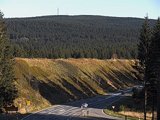
The Harz is a highland area in northern Germany. It has the highest elevations for that region, and its rugged terrain extends across parts of Lower Saxony, Saxony-Anhalt, and Thuringia. The name Harz derives from the Middle High German word Hardt or Hart. The name Hercynia derives from a Celtic name and could refer to other mountain forests, but has also been applied to the geology of the Harz. The Brocken is the highest summit in the Harz with an elevation of 1,141.1 metres (3,744 ft) above sea level. The Wurmberg is the highest peak located entirely within the state of Lower Saxony.

Braunlage is a town and health resort in the Goslar district of Lower Saxony in Germany. Situated within the Harz mountain range, south of the Brocken massif, Braunlage's main business is tourism, particularly skiing. Nearby ski resorts include the Sonnenberg and the slopes on the Wurmberg.

Sankt Andreasberg is a former town in the district of Goslar, in Lower Saxony, Germany. Since 1 November 2011, it is part of the town Braunlage. It is situated in the Harz, approximately 7 km west of Braunlage proper, and 20 km east of Osterode am Harz.

The Upper Harz is the northwestern and higher part of the Harz mountain range in Germany. The exact boundaries of this geographical region may be defined differently depending on the context. In its traditional sense, the term Upper Harz covers the area of the seven historical mining towns (Bergstädte) - Clausthal, Zellerfeld, Andreasberg, Altenau, Lautenthal, Wildemann and Grund - in the present-day German federal state of Lower Saxony. Orographically, it comprises the Harz catchment areas of the Söse, Innerste and Grane, Oker and Abzucht mountain streams, all part of the larger Weser watershed.
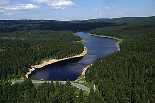
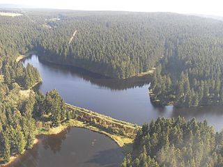
The Oderteich is an historic reservoir about seven kilometres northeast of Sankt Andreasberg in the Upper Harz in central Germany. It was built by miners from St. Andreasberg in the years 1715 to 1722 and, today, is an important component of the water supply network known as the Upper Harz Water Regale. Moreover, for 170 years, from the time it was completed to the end of the 19th century, the Oderteich had the largest dam in Germany. The dam lies at a height of 725 m above NN by the B 242 federal highway, about a kilometre west of its intersection with the B 4.

The Upper Harz Ponds are found mainly around the mining town of Clausthal-Zellerfeld and the nearby villages of Buntenbock and Hahnenklee in the Upper Harz mountains of central Germany. There are around 70 ponds in total, both large and small. They were built by the miners of the Upper Harz, mostly between the 16th and 18th centuries, and are important components of the cultural monument known as the Upper Harz Water Regale - a network of dams, ditches, ponds and tunnels that was built to supply much-needed water power for the mining industry in the Harz mountains. Today the Water Regale is being proposed as a UNESCO World Heritage Site. About half the dammed ponds are classified today as reservoirs, but they have now become characteristic features of the Upper Harz and are home to some extremely rare plant and animal species.
The Sperberhai Dyke is in fact an aqueduct which forms part of the Upper Harz Water Regale network of reservoirs, ditches, dams and tunnels in the Harz mountains of central Germany. It carries the water of the Dyke Ditch over the depression of the Sperberhai to the Clausthal plateau.

The Harz Witches' Trail is a footpath, just under 100 km long, in Germany that runs from Osterode through the Harz mountains and over its highest peak, the Brocken, to Thale. It is a project by the Harz Transport Association and Harz Club and is part of the system of trails known as the Harzer Wandernadel.
The Upper Harz Water Regale is a system of dams, reservoirs, ditches and other structures, much of which was built from the 16th to 19th centuries to divert and store the water that drove the water wheels of the mines in the Upper Harz region of Germany. The term regale, here, refers to the granting of royal privileges or rights in this case to permit the use of water for mining operations in the Harz mountains of Germany.
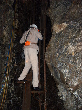
The Samson Pit or Samson Mine is an historic silver mine in Sankt Andreasberg in the Upper Harz region of central Germany.
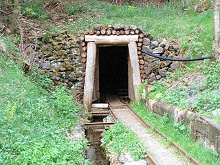
The Roter Bär Pit in Sankt Andreasberg in the Upper Harz is an iron ore mine that was worked from about 1800 until the 1860s. Today it is operated as a show mine under the name of Roter Bär Pit Educational Mine by the Sankt Andreasberg Society for History and Archaeology. The name Roter Bär means "Red Bear".

Within the Lower Harz region are still many traces of the historical water management facilities used by the mining industry. In addition to water-carrying ditches and ponds, there are also long-abandoned ditches and dry pond beds. The Lower Harz Pond and Ditch System, which forms the major part of these old water management facilities, lies in the central Lower Harz, almost entirely within the borough of the present-day town of Harzgerode.
The Bärenbrucher Teich is an historic reservoir in the Harz Mountains of central Germany. It lies east of Buntenbock near Clausthal-Zellerfeld.

The Bergrat Müller Pond, named after a former mining director, Müller, in the Harz mountains of central Germany is a storage pond laid out from 1737 to 1738. It has an area of about 1.3 ha and lies in the forested southern part of the borough of Quedlinburg in the county of Harz in Saxony-Anhalt.
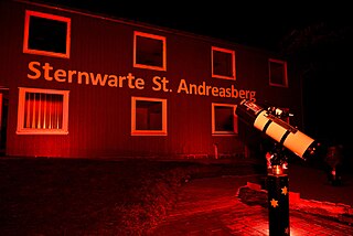
The Sankt Andreasberg Observatory, also called Harz Observatory, is a project of the charitable society Sternwarte Sankt Andreasberg e. V., which translates into Sankt Andreasberg Observatory registered society. It was opened in August 2014 and is supposed to become the first completely barrier free Observatory in Germany. The society's expressive goal is to make the sky accessible to all people, whether they are disabled or not. Celestial observation, lectures and Workshops convey general astronomical knowledge to visitors.

The Grünhirscher Stollen is an adit for water drainage in Sankt Andreasberg, in the Harz mountains. It was created during mining in the Upper Harz and named after the valley Grüner Hirsch between the mountains Galgenberg and Glockenberg. It leads from the Samson Pit to the south-west of the Galgenberg.
The Sieberstollen is an adit for water drainage in Sankt Andreasberg, in the Harz mountains. It was created during mining in the Upper Harz and named after the river Sieber into which it discharges its water. The opening position is in the Sieber Valley.

Silberhütte was once a village in the formerly free mining town of Sankt Andreasberg in the Harz mountains in Germany, but since its merger on 1 November 2011 it has been part of the borough of Braunlage. The name of the village goes back to the silver works that was existed here until 1912 and which smelted the ores from the mines around Sankt Andreasberg.
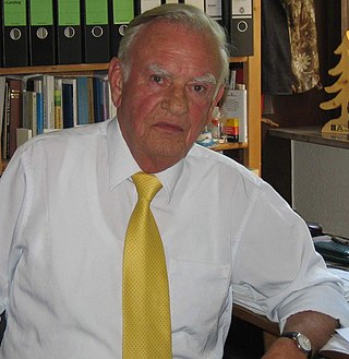
Werner Grübmeyer was a German politician. He was a member of the Christian Democratic Union (CDU).