Silver Creek (Ohio River tributary)

Last updated
Silver Creek

Silver Creek Lapping.jpg

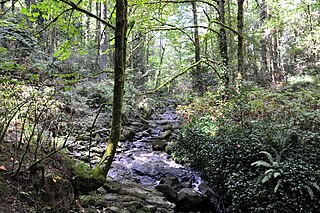
Silver Creek, by Lapping Park
Country US
Physical characteristics
River mouth Ohio River
Length 38 miles (61 km)
Basin features
Basin size 97,442 acres (394.33 km2)

Silver Creek is a stream in southern Indiana in the United States. It drains a watershed of 97,442 acres (394.33 km2). [1] The creek rises in Scott County and flows 38.0 miles (61.2 km), [2] dropping 168 feet (51 m), before flowing into the Ohio River.

Stream A body of surface water flowing down a channel

A stream is a body of water with surface water flowing within the bed and banks of a channel. The stream encompasses surface and groundwater fluxes that respond to geological, geomorphological, hydrological and biotic controls.

Indiana State of the United States of America

Indiana is a U.S. state located in the Midwestern and Great Lakes regions of North America. Indiana is the 38th largest by area and the 17th most populous of the 50 United States. Its capital and largest city is Indianapolis. Indiana was admitted to the United States as the 19th U.S. state on December 11, 1816. Indiana borders Lake Michigan to the northwest, Michigan to the north, Ohio to the east, Kentucky to the south and southeast, and Illinois to the west.

United States federal republic in North America

The United States of America (USA), commonly known as the United States or America, is a country composed of 50 states, a federal district, five major self-governing territories, and various possessions. At 3.8 million square miles, the United States is the world's third or fourth largest country by total area and is slightly smaller than the entire continent of Europe's 3.9 million square miles. With a population of over 327 million people, the U.S. is the third most populous country. The capital is Washington, D.C., and the largest city by population is New York. Forty-eight states and the capital's federal district are contiguous in North America between Canada and Mexico. The State of Alaska is in the northwest corner of North America, bordered by Canada to the east and across the Bering Strait from Russia to the west. The State of Hawaii is an archipelago in the mid-Pacific Ocean. The U.S. territories are scattered about the Pacific Ocean and the Caribbean Sea, stretching across nine official time zones. The extremely diverse geography, climate, and wildlife of the United States make it one of the world's 17 megadiverse countries.

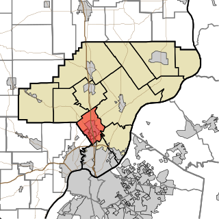
It forms the boundary between Clark and Floyd counties. The stream was called Silver Creek by the time it was part of land granted to George Rogers Clark, who lived in a log cabin near the creek's mouth. [3] It was named Silver Creek due to a rumor that silver treasure was hidden by creek, and that silver ore could be found. [4] [5]

Clark County, Indiana county in Indiana, United States

Clark County is a county located in the U.S. state of Indiana, located directly across the Ohio River from Louisville, Kentucky. At the 2010 Census, the population was 110,232. The county seat is Jeffersonville.

Floyd County, Indiana county in Indiana, United States

Floyd County is a county located in the U.S. state of Indiana. As of 2012, the population was 75,283. The county seat is New Albany. Floyd County is the county with the second-smallest land area in the entire state. It was formed in the year 1819 from neighboring Clark, and Harrison counties.

George Rogers Clark American general

George Rogers Clark was an American surveyor, soldier, and militia officer from Virginia who became the highest ranking American military officer on the northwestern frontier during the American Revolutionary War. He served as leader of the militia in Kentucky throughout much of the war. He is best known for his celebrated captures of Kaskaskia (1778) and Vincennes (1779) during the Illinois Campaign, which greatly weakened British influence in the Northwest Territory. The British ceded the entire Northwest Territory to the United States in the 1783 Treaty of Paris, and Clark has often been hailed as the "Conqueror of the Old Northwest".

At the mouth of the creek was the first cement operation in Indiana, at Beach's Mill in 1830. [6]

Cement Hydraulic binder used in the composition of mortar and concrete

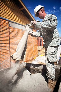
A cement is a binder, a substance used for construction that sets, hardens, and adheres to other materials to bind them together. Cement is seldom used on its own, but rather to bind sand and gravel (aggregate) together. Cement mixed with fine aggregate produces mortar for masonry, or with sand and gravel, produces concrete. Cement is the most widely used material in existence and is only behind water as the planet's most-consumed resource.

The creek was the site of Shirt-Tail Bend, a popular dueling location for Kentuckians, as the practice was illegal in their state. The Silver Creek banks were the site at least four duels, including most famously one between Humphrey Marshall and Henry Clay on January 19, 1809. Both men suffered slight wounds. Marshall opposed Clay's proposal that all Kentucky legislators should wear domestic homespun rather than English broadcloth. [3]

Kentucky State of the United States of America

Kentucky, officially the Commonwealth of Kentucky, is a state located in the east south-central region of the United States. Although styled as the "State of Kentucky" in the law creating it, (because in Kentucky's first constitution, the name state was used) Kentucky is one of four U.S. states constituted as a commonwealth. Originally a part of Virginia, in 1792 Kentucky became the 15th state to join the Union. Kentucky is the 37th most extensive and the 26th most populous of the 50 United States.

Henry Clay American politician

Henry Clay Sr. was an American attorney and statesman who represented Kentucky in both the United States Senate and United States House of Representatives, served as 7th speaker of the U.S. House of Representatives, and served as the 9th U.S. secretary of state. He received electoral votes for president in the 1824, 1832, and 1844 presidential elections and helped found both the National Republican Party and the Whig Party. For his role in defusing sectional crises, he earned the appellation of the "Great Compromiser."

Broadcloth dense, fulled, plain woven cloth, historically made of wool

Broadcloth is a dense, plain woven cloth, historically made of wool. The defining characteristic of Broadcloth is not its finished width, but the fact that it was woven much wider and then heavily milled in order to shrink it to the required width. The effect of the milling process is to draw the yarns much closer together than could be achieved in the loom and allow the individual fibres of the wool to bind together in a felting process. This results in a dense, blind face cloth with a stiff drape which is highly weather-resistant, hard wearing and capable of taking a cut edge without the need for being hemmed.

See also

Related Research Articles

Clark County, Illinois county in Illinois, United States

Clark County is a county located in the southeastern part of U.S. state of Illinois, along the Indiana state line. As of the 2010 census, the population was 16,335. Its county seat is Marshall. The county was named for George Rogers Clark, an officer who served in the American Revolution.

Clarksville, Indiana Town in Indiana, United States

Clarksville is a town in Clark County, Indiana, United States, along the Ohio River and is a part of the Louisville Metropolitan area. The population was 21,724 at the 2010 census. The town was founded in 1783 by early resident George Rogers Clark at the only seasonal rapids on the entire Ohio River, it is the oldest American town in the former Northwest Territory. The town is home to the Colgate clock, one of the largest clocks in the world and the Falls of the Ohio State Park, home to the world's largest exposed Devonian period fossil bed.

Clark Fork River river in the United States of America

The Clark Fork, or the Clark Fork of the Columbia River, is a river in the U.S. states of Montana and Idaho, approximately 310 miles (500 km) long. The largest river by volume in Montana, it drains an extensive region of the Rocky Mountains in western Montana and northern Idaho in the watershed of the Columbia River. The river flows northwest through a long valley at the base of the Cabinet Mountains and empties into Lake Pend Oreille in the Idaho Panhandle. The Pend Oreille River in Idaho, Washington, and British Columbia, Canada which drains the lake to the Columbia in Washington, is sometimes included as part of the Clark Fork, giving it a total length of 479 miles (771 km), with a drainage area of 25,820 square miles (66,900 km2). In its upper 20 miles (32 km) in Montana near Butte, it is known as Silver Bow Creek. Interstate 90 follows much of the upper course of the river from Butte to northwest of Missoula. The highest point within the river's watershed is Mount Evans at 10,641 feet (3,243 m) in Deer Lodge County, Montana along the Continental Divide.

Red River (Cumberland River) river in Tennessee and Kentucky, United States

The Red River, 100 miles (161 km) long, is a major stream of north-central Tennessee, United States and south-central Kentucky and a major tributary of the Cumberland River.

The Driftwood River is a 15.5-mile-long (24.9 km) tributary of the East Fork of the White River in central Indiana in the United States. Via the White, Wabash and Ohio rivers, it is part of the watershed of the Mississippi River. It is a short river, formed by the confluence of two longer streams a short distance upstream of its mouth.

Larrys Creek tributary of the West Branch Susquehanna River

Larrys Creek is a 22.9-mile-long (36.9 km) tributary of the West Branch Susquehanna River in Lycoming County in the U.S. state of Pennsylvania. A part of the Chesapeake Bay drainage basin, its watershed drains 89.1 square miles (231 km2) in six townships and a borough. The creek flows south from the dissected Allegheny Plateau to the Ridge-and-valley Appalachians through sandstone, limestone, and shale from the Devonian, Mississippian, and Pennsylvanian periods.

Fourteen Mile Creek river in the United States of America

Fourteen Mile Creek, shown as Fourteenmile Creek on federal maps, is a 22.7-mile-long (36.5 km) creek in Clark County, Indiana, close to Charlestown. It is so named because its mouth on the Ohio River is 14 miles (23 km) upstream from the Falls of the Ohio; similar to how Eighteen Mile Island, Twelve Mile Island, and Six Mile Island got their names. It is navigable for 2.9 miles (4.7 km) from the Ohio River. It is a State Heritage Program Site and a popular canoe trail.

Cocalico Creek river in the United States of America

Cocalico Creek is a 27.2-mile-long (43.8 km) tributary of the Conestoga River in Lebanon and Lancaster counties in Pennsylvania in the United States. The source is at an elevation of 1,320 feet (400 m) near Stricklerstown in Millcreek Township, Lebanon County. The mouth is the confluence with the Conestoga River at an elevation of 278 feet (85 m) at Talmage in West Earl Township, Lancaster County.

Conewago Creek (west) west tributary of the Susquehanna River in Pennsylvania, United States

Conewago Creek is an 80.2-mile-long (129.1 km) tributary of the Susquehanna River in Adams and York counties in Pennsylvania in the United States, with its watershed also draining a small portion of Carroll County, Maryland. The source is at an elevation of 1,440 feet (440 m), east of Caledonia State Park, in Franklin Township in Adams County. The mouth is the confluence with the Susquehanna River at York Haven in York County at an elevation of 259 feet (79 m).

Green Tree Mall shopping mall in Clarksville, Indiana, United States

Green Tree Mall is an American shopping mall located in Clarksville, Indiana. The mall is located off of I-65 about four miles (6 km) north of downtown Louisville. It has a total area of 795,382 square feet (73,893 m2). It was named for a large boundary tree of considerable age that once stood at the location. Currently, there are more than 80 inline stores and 2 major anchor stores. The third anchor was Sears which closed on October 1, 2017. The mall is managed by CBL & Associates Properties, who bought it from Macerich in 2013.

Coldwater River (Western Michigan)

The Coldwater River is a 19.4-mile-long (31.2 km) stream in the U.S. state of Michigan. Located in western Michigan, the river is a part of the Grand River drainage basin.

Tryon Creek tributary of the Willamette River in Oregon

Tryon Creek is a 4.85-mile (7.81 km) tributary of the Willamette River in the U.S. state of Oregon. Part of the drainage basin of the Columbia River, its watershed covers about 6.5 square miles (16.8 km2) in Multnomah and Clackamas counties. The stream flows southeast from the Tualatin Mountains through the Multnomah Village neighborhood of Portland and the Tryon Creek State Natural Area to the Willamette in the city of Lake Oswego. Parks and open spaces cover about 21 percent of the watershed, while single-family homes dominate most of the remainder. The largest of the parks is the state natural area, which straddles the border between the two cities and counties.

Silver Creek Township, Clark County, Indiana Township in Indiana, United States

Silver Creek Township is one of twelve townships in Clark County, Indiana. As of the 2010 census, its population was 11,858 and it contained 4,858 housing units.

Camp Joe Holt hospital

Camp Joe Holt was a Union base during the American Civil War in Jeffersonville, Indiana, across the Ohio River from Louisville, Kentucky, on land that is now part of Clarksville, Indiana, near the Big Eddy. It was a major staging area for troops in the Western Theatre of the War, in preparation for invading the Confederate States of America. Its establishment was the first major step performed by Kentucky Unionists to keep Kentucky from seceding to the Confederacy.

Hamburg, Clark County, Indiana Unincorporated community in Indiana, United States

Hamburg is an unincorporated community in Silver Creek Township, Clark County, Indiana. Parts of Hamburg are within the municipal boundaries of Clarksville and Sellersburg.

Kent, Jefferson County, Indiana Census-designated place in Indiana, United States

Kent is an unincorporated community and census-designated place (CDP) in Republican Township, Jefferson County, Indiana, United States. As of the 2010 census it had a population of 70.

Pigeon Creek (Indiana) river in the United States of America

Pigeon Creek is a tributary of the Ohio River in southwestern Indiana. It runs approximately 47.5 miles (76.4 km) from its eastern source in rural Gibson County near Princeton and its western source near Owensville. The forks merge southeast of Fort Branch, and from there it heads southeast into Warrick County near Lynnville, from where it heads south. The larger creek then turns west crossing into Vanderburgh County under Interstate 69. The creek has a few more tributaries join as it first heads west through Evansville's East and North Sides then south through Downtown Evansville, where it empties into the Ohio River.

Blackiston Mill is an unincorporated community located in Floyd County, Indiana at latitude 38.336 and longitude -85.798. The elevation is 446 feet (136 m).

Mahantango Creek is a 2.1-mile-long (3.4 km) tributary of the Susquehanna River in Snyder and Juniata counties, Pennsylvania, in the United States. Its name comes from a Delaware Indian word meaning "where we had plenty to eat". The creek flows along the border between Snyder County and Juniata County.

Silver Creek is a tributary of the Susquehanna River in Snyder County, Pennsylvania, in the United States. It is approximately 6.1 miles (9.8 km) long and flows through Washington Township and Union Township. The watershed of the creek has an area of 5.92 square miles (15.3 km2). The creek has no named tributaries, but it does have several unnamed tributaries. Many of these, as well as Silver Creek itself, are impaired by sedimentation/siltation due to grazing-related agriculture. The watershed is partly or fully in the Ridge and Valley physiographic province.

References

  1. "Silver Creek Watershed Improvement Project". Clark County Soil and Water Preservation District. Retrieved 2007-11-13.
  2. U.S. Geological Survey. National Hydrography Dataset high-resolution flowline data. The National Map, accessed May 19, 2011
  3. 1 2 Amster, Betty Lou (2001). "Silver Creek". In Kleber, John E. Encyclopedia of Louisville.
  4. Sarles, Jane. Journeys Through Clarksville's Past. (2006) p.54
  5. Indiana Names, v.4. Terre Haute, IN: Indiana State University. 1973. p. 24.
  6. Sarles, Jane. Journeys Through Clarksville's Past. (2006) p.38

Coordinates: 38°17′18″N85°47′30″W / 38.28833°N 85.79167°W / 38.28833; -85.79167

Geographic coordinate system Coordinate system

A geographic coordinate system is a coordinate system that enables every location on Earth to be specified by a set of numbers, letters or symbols. The coordinates are often chosen such that one of the numbers represents a vertical position and two or three of the numbers represent a horizontal position; alternatively, a geographic position may be expressed in a combined three-dimensional Cartesian vector. A common choice of coordinates is latitude, longitude and elevation. To specify a location on a plane requires a map projection.