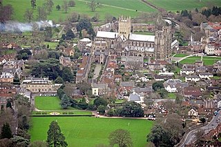
Wells is a cathedral city and civil parish in Somerset, located on the southern edge of the Mendip Hills, 21 miles (34 km) south-east of Weston-super-Mare, 22 mi (35 km) south-west of Bath and 23 mi (37 km) south of Bristol. Although the population recorded in the 2011 census was only 10,536, and with a built-up area of just 3.244 km2 (1.253 sq mi), Wells has had city status since medieval times, because of the presence of Wells Cathedral. Often described as England's smallest city, it is actually second smallest to the City of London in area and population, but unlike London it is not part of a larger urban agglomeration.

Street is a large village and civil parish in Somerset, England, with a population of 12,709 in 2021. On a dry spot in the Somerset Levels, at the end of the Polden Hills, it is two miles southwest of Glastonbury. There is evidence of Roman occupation. Much of the history of the village is dominated by Glastonbury Abbey, and a 12th-century causeway from Glastonbury built to transport local Blue Lias stone to it.

Yeovil is a town and civil parish in Somerset, England. The population of Yeovil at the last census (2021) was 49,698. It is close to Somerset's southern border with Dorset, 126 miles (203 km) west of London, 41.8 miles (67.3 km) south of Bristol, 6 miles (9.7 km) west of Sherborne and 27.6 miles (44.4 km) east of Taunton. The aircraft and defence industries which developed in the 20th century made it a target for bombing in the Second World War; they are still major employers. Yeovil Country Park, which includes Ninesprings, is one of several open spaces with educational, cultural and sporting facilities. Religious sites include the 14th-century Church of St John the Baptist. The town is on the A30 and A37 roads and has two railway stations.

Ilminster is a market town and civil parish in the South Somerset district of Somerset, England, with a population of 5,808. Bypassed in 1988, the town now lies just east of the junction of the A303 and the A358. The parish includes the hamlet of Sea.

Ilchester is a village and civil parish, situated on the River Yeo or Ivel, five miles north of Yeovil, in the English county of Somerset. Originally a Roman town, and later a market town, Ilchester has a rich medieval history and was a notable settlement in the county; around the 12th and 13th centuries it was effectively the county town. It had, however, declined in size and importance by the beginning of the 18th century, and the last markets were held in 1833. In 1889 the historic corporation that had governed the town was dissolved.

Wellington is a market town in Somerset, England. It is situated 7 miles (11 km) south west of Taunton, near the border with Devon, which runs along the Blackdown Hills to the south of the town. The town had a population of 16,669, which includes the residents of the parish of Wellington Without, and the villages of Tone and Tonedale.

Midsomer Norton is a town near the Mendip Hills in Bath and North East Somerset, England, 10 miles (16 km) south-west of Bath, 10 miles (16 km) north-east of Wells, 10 miles (16 km) north-west of Frome, 12 miles (19 km) west of Trowbridge and 16 miles (26 km) south-east of Bristol. It has a population of around 13,000. Along with Radstock and Westfield it used to be part of the conurbation and large civil parish of Norton Radstock, but is now a town council in its own right. It is also part of the unitary authority of Bath and North East Somerset.

Shapwick is a village on the Polden Hills overlooking the Somerset Moors, in Somerset, England. It is situated to the west of Glastonbury.
Wiveliscombe is a town and civil parish in Somerset, England, situated 9 miles (14 km) west of Taunton. The town has a population of 2,893. The Square, fronted by several listed structures, held the former market. The parish includes the nearby hamlet of Maundown.
Bruton is a market town, electoral ward, and civil parish in Somerset, England, on the River Brue and the A359 between Frome and Yeovil. It is 7 miles (11 km) south-east of Shepton Mallet, just south of Snakelake Hill and Coombe Hill, 10 miles (16 km) north-west of Gillingham and 12 miles (19 km) south-west of Frome. The town and ward have a population of 2,907. The parish includes the hamlets of Wyke Champflower and Redlynch.

Donyatt is a village and civil parish in Somerset, England, situated at the source of the River Isle 5 miles (8.0 km) north of Chard in the South Somerset district. The village has a population of 347. The parish includes the hamlet of Peasmarsh.

Stogursey is a small village and civil parish in the Quantock Hills in Somerset, England. It is situated 3 miles (4.8 km) from Nether Stowey, and 8 miles (12.9 km) west of Bridgwater. The village is situated near the Bristol Channel, which bounds the parish on the north.
Kilve is a village in the Somerset West and Taunton district of Somerset, England, within the Quantock Hills Area of Outstanding Natural Beauty, the first AONB to be established, in 1957.

Charterhouse, also known as Charterhouse-on-Mendip, is a hamlet and former civil parish, now in the parish of Priddy, in the Mendip Hills Area of Outstanding Natural Beauty (AONB) in the Somerset district, in the ceremonial county of Somerset, England. The area between Charterhouse and Cheddar Gorge including Velvet Bottom and Ubley Warren is covered by the Cheddar Complex Site of Special Scientific Interest. In 1931 the parish had a population of 68.

Walton is a village and civil parish on the Polden Hills in Somerset, England, 1.5 miles (2.4 km) west of Street. The parish includes the hamlet of Asney.
Benjamin Ferrey FSA FRIBA was an English architect who worked mostly in the Gothic Revival.

South Petherton is a large village and civil parish in the South Somerset district of Somerset, England, located 5 miles (8 km) east of Ilminster and 5 miles (8 km) north of Crewkerne. The parish had a population of 3,737 in 2021 and includes the smaller village of Over Stratton and the hamlets of Compton Durville, Drayton, Wigborough and Yeabridge. The River Parrett forms the eastern boundary of the parish. The village is approximately 2 miles (3 km) from East Lambrook, Martock and Lopen.