
The Rio Grande in the United States or the Río Bravo in Mexico, also known as P’osoge in Tewa and Tó Ba’áadi in Navajo, is one of the principal rivers in the Southwestern United States and in northern Mexico. The length of the Rio Grande is 1,896 miles (3,051 km), making it the 4th longest river in the United States and in North America by main stem. It originates in south-central Colorado, in the United States, and flows to the Gulf of Mexico. The Rio Grande drainage basin (watershed) has an area of 182,200 square miles (472,000 km2); however, the endorheic basins that are adjacent to and within the greater drainage basin of the Rio Grande increase the total drainage-basin area to 336,000 square miles (870,000 km2).

The Pecos River originates in north-central New Mexico and flows into Texas, emptying into the Rio Grande. Its headwaters are on the eastern slope of the Sangre de Cristo mountain range in Mora County north of Pecos, New Mexico, at an elevation of over 12,000 feet (3,700 m). The river flows for 926 miles (1,490 km) before reaching the Rio Grande near Del Rio. Its drainage basin encompasses about 44,300 square miles (115,000 km2).
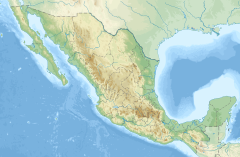
Sinaloa, officially the Estado Libre y Soberano de Sinaloa, is one of the 31 states which, along with Mexico City, compose the Federal Entities of Mexico. It is divided into 18 municipalities, and its capital city is Culiacán Rosales.

Culiacán, officially Culiacán Rosales, is a city in northwestern Mexico, the capital and largest city of both Culiacán Municipality and the state of Sinaloa. The city was founded on 29 September 1531 by the Spanish conquerors Lázaro de Cebreros and Nuño Beltrán de Guzmán under the name "Villa de San Miguel", referring to its patron saint, Michael the Archangel.

The Gila River is a 649-mile-long (1,044 km) tributary of the Colorado River flowing through New Mexico and Arizona in the United States. The river drains an arid watershed of nearly 60,000 square miles (160,000 km2) that lies mostly within the U.S., but also extends into northern Sonora, Mexico.
The Canadian River is the longest tributary of the Arkansas River in the United States. It is about 1,026 miles (1,651 km) long, starting in Colorado and traveling through New Mexico, the Texas Panhandle, and Oklahoma. The drainage area is about 47,700 square miles (124,000 km2).

The Eucumbene River, a perennial river of the Snowy River catchment, is located in the Snowy Mountains region of New South Wales, Australia.
The Fuerte River is a river in the state of Sinaloa, in northwestern Mexico. It flows from headwaters in the Sierra Madre Occidental to the Pacific Ocean in the Gulf of California.
The Rio Chama, a major tributary river of the Rio Grande, is located in the U.S. states of Colorado and New Mexico. The river is about 130 miles (210 km) long altogether. From its source to El Vado Dam its length is about 50 miles (80 km), from El Vado Dam to Abiquiu Dam is about 51 miles (82 km), and from Abiquiu Dam to its confluence with the Rio Grande is about 34 miles (55 km).

Hurricane Naomi was a short-lived and damaging Category 1 hurricane that made landfall in Mexico's Pacific coast during the 1968 Pacific hurricane season. After rapidly intensifying before its landfall in Sinaloa, Naomi caused rainfall throughout northern Mexico and the U.S. state of Texas in association with a frontal system, with the highest measurement occurring in Corpus Christi. Four people perished in Mexico due to Naomi's effects with ten more missing, all in Sinaloa. The only reported injury in Texas due to the remnants was a factory worker who was injured when the roof of the plant they were working in collapsed due to rainfall.

The Tumut River, a perennial stream that is part of the Murrumbidgee catchment within the Murray–Darling basin, is located in the Snowy Mountains and South West Slopes districts of New South Wales, Australia.

The Lower Colorado River Valley (LCRV) is the river region of the lower Colorado River of the southwestern United States in North America that rises in the Rocky Mountains and has its outlet at the Colorado River Delta in the northern Gulf of California in northwestern Mexico, between the states of Baja California and Sonora. This north–south stretch of the Colorado River forms the border between the U.S. states of California/Arizona and Nevada/Arizona, and between the Mexican states of Baja California/Sonora.
The Mangrove Creek, a perennial river that is part of the Hawkesbury-Nepean catchment, is located in the Central Coast region of New South Wales, Australia.
The Baluarte River, is a river of Mexico in the states of Durango and Sinaloa, traversing 142 km, part of which forms the border between these two states.
The Presidio River is a river of Mexico. It originates in the mountains of Durango, flowing south-southwesterly into Sinaloa before joining the Pacific Ocean southeast of Mazatlán. The watershed measures 6,479 km2 (2,502 sq mi).
The Moctezuma River is a river in Mexico that drains the eastern side of the Trans-Mexican Volcanic Belt. It is a tributary of the Pánuco River and flows through the Mexican states of Hidalgo, Querétaro, and San Luis Potosí.

The Alamo Canal was a 14 mi (23 km) long waterway that connected the Colorado River to the head of the Alamo River. The canal was constructed to provide irrigation to the Imperial Valley. A small portion of the canal was located in the United States but the majority of the canal was located in Mexico. The Alamo Canal is also known as the Imperial Canal.

Tropical Storm Lidia was the deadliest tropical cyclone of the 1981 Pacific hurricane season. On October 6, a tropical depression formed and strengthened into a tropical storm six hours later. Lidia brushed the southern tip of the Mexican state of Baja California Sur and made landfall just south of Los Mochis in Sinaloa on October 8 as a mid-level tropical storm. Once onshore, Tropical Storm Lidia rapidly weakened and dissipated the same day. It inflicted heavy rain and flooding throughout parts of northwestern Mexico, especially Sinaloa. Overall, Lidia killed 100 people and caused at least $80 million in damage.
Huites Dam, officially known as Luis Donaldo Colosio Dam, is located on the Rio Fuerte in northwestern Sinaloa, Mexico 130 kilometres (81 mi) northeast of Los Mochis. The 162-metre (531 ft)-high, hybrid concrete arch-gravity dam impounds a reservoir called Lago Huites or Presa Luís Donaldo Colosio and is owned by the Comisión Federal de Electricidad.

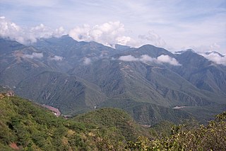
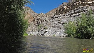
The Chínipas is a river of northwestern Mexico. The Chinipas arises deep in the Sierra Madre Occidental in the state of Chihuahua, and then flows through long rugged canyon systems into the state of Sinaloa until it finally joins the main trunk of the Fuerte River in the western foothills of the Sierra Madre Occidental. The Fuerte River then flows westward over the western coastal plain of Sonora to the Pacific Ocean, emerging very near the port of Topolobampo.
