
Bowling Green Bay is a national park in the City of Townsville and Shire of Burdekin, Queensland, Australia, 1,103 km northwest of Brisbane, and 28 km south of Townsville and 59 km north of Ayr. It is a Ramsar Convention listed site. The park protects diverse range of habitats including the rugged, forested landscape surrounding Mount Elliot and Saddle Mountain as well as coastal estuaries between Cape Cleveland and Cape Bowling Green.
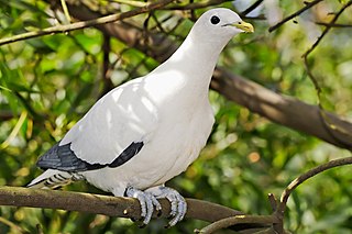
The Brook Islands National Park is a national park in Cassowary Coast Region, Queensland, Australia, 1246 km northwest of Brisbane, with an area of 0.9 km2. It was established in 1994 and comprises three islands - North, Tween and Middle - which lie off the coast 7 km north-east of Cape Richards on Hinchinbrook Island and 30 km east of the nearest mainland town of Cardwell. The fourth island of the Brooks group, South Island, is not part of the national park but is protected by the Great Barrier Reef Marine Park Authority. Public access to the three islands in the national park is prohibited in order to protect breeding birds, especially the Torresian imperial-pigeon. The islands have no roads, walking tracks or other facilities. Popular activities in the waters around the islands are boating, snorkelling and fishing. The islands are managed by the Queensland Parks and Wildlife Service. The Park's IUCN category is II.

Cape Hillsborough is a national park in Mackay Region, Queensland, Australia.

Cape Melville is a national park in the Shire of Cook, Queensland, Australia.

Cape Upstart is a national park in the locality of Guthalungra in the Whitsunday Region local government area of North Queensland, Australia, 1,016 km northwest of Brisbane.

Cliff Island is a national park at Yarraden on Cape York Peninsula in Far North Queensland, Australia, 1,757 km northwest of Brisbane. It is part of the Great Barrier Reef Marine Park west of Cape Melville in Princess Charlotte Bay. The park is a restricted access area in order to protect cultural resource of the islands traditional owners, the Lama Lama people.
Forbes Islands is a national park in Queensland, Australia, 1,962 km northwest of Brisbane in the Great Barrier Reef Marine Park Queensland and is located about 40 km North East of Iron Range National Park and Lockhart River in the Cape Weymouth area in the Coral Sea just off the small locality of Portland Roads.

Gloucester Island is a national park in Queensland, Australia, 950 km northwest of Brisbane. It is visible from the town of Bowen. The island was seen and erroneously named "Cape Gloucester" by British explorer James Cook in 1770. The name "Cape Gloucester" has been used informally for areas on or near Gloucester Island.

Hope Islands National Park is a national park in Queensland (Australia) 1,521 km north-west of Brisbane. The park consists of four islands: East Hope and West Hope, Snapper Island and Struck Island.

Oyala Thumotang, formerly Mungkan Kandju National Park, is a national park in Queensland, Australia, 1,914 kilometres (1,189 mi) northwest of Brisbane.
Three Islands and Three Islands Reef are part of the Three Islands Group National Park in Far North Queensland, Australia, in the Coral Sea, 1,581 km (982 mi) northwest of Brisbane, about 44 km (27 mi) north-northeast of Cooktown.
Two Islands and Two Islands Reef are part of the Three Islands Group National Park in Far North Queensland, Australia, in the Coral Sea, 1,590 km (990 mi) northwest of Brisbane, about 50 km (31 mi) north-northeast of Cooktown, 10 km (6.2 mi) southeast of Cape Flattery, and 10 km (6.2 mi) north of Three Islands and Three Islands Reef.
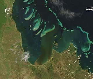
Princess Charlotte Bay is a large bay on the east coast of Far North Queensland at the base of Cape York Peninsula, 350 km north northwest of Cairns. Princess Charlotte Bay is a part of the Great Barrier Reef Marine Park and it is a habitat for the dugong.

Cape Tribulation is a headland and coastal locality in the Shire of Douglas in northern Queensland, Australia.. In the 2016 census, Cape Tribulation had a population of 118 people.
Halfway Islet is a small island in the Boydong cays, Shelburne Bay in far north Queensland, Australia about 100 km north of Cape Grenville, Cape York Peninsula in the Great Barrier Reef Marine Park Queensland, Australia.
Quoin Island is a national park in the Great Barrier Reef Marine Park Queensland, Australia, 1,947 km northwest of Brisbane. It is situated about 30 km North East of Iron Range National Park and Lockhart River in the Cape Weymouth area near Portland Roads

Cape Melville is a headland on the eastern coast of the Cape York Peninsula in Australia. To its west lies Princess Charlotte Bay. It is part of the Cape Melville National Park.
Alwal National Park is a national park in the Shire of Cook on the Cape York Peninsula in Far North Queensland, Australia.

Lama Lama National Park is a national park on Cape York Peninsula in Far North Queensland, Australia. The name comes from the Lama Lama people who are the traditional owners of the land. The park protects coastal plains, beach ridges and sandy hills of the Annie River water catchment. The river marks the southern border of the park.
Haggerstone Island is a privately owned resort island, 10 km (6 mi) southeast of Cape Grenville in the Great Barrier Reef Marine Park of Far North Queensland, Australia.


