
The Indus is a transboundary river of Asia and a trans-Himalayan river of South and Central Asia. The 3,180 km (1,980 mi) river rises in Western Tibet, flows northwest through the Ladakh and Gilgit-Baltistan regions of Kashmir, bends sharply to the left after the Nanga Parbat massif, and flows south-by-southwest through Pakistan, before it empties into the Arabian Sea near the port city of Karachi.

The Thar Desert, also known as the Great Indian Desert, is a large, arid region in the northwestern part of the Indian subcontinent that covers an area of 200,000 km2 (77,000 sq mi) and forms a natural boundary between India and Pakistan. It is the world's 20th-largest desert, and the world's 9th-largest hot subtropical desert.

Lake Manchar, also spelled Manchhar, is the largest natural freshwater lake in Pakistan, and is one of Asia's largest. It is located west of the Indus River, in Jamshoro District and Dadu District, Sindh - 18 km away from Sehwan Sharif. Lake Manchar collects water from numerous small streams in the Kirthar Mountains, and then empties into the Indus River. The lake's surface area fluctuates with the seasons - from as little as 36 km², to as much as 500 km² during monsoon rains.

Tarbela Dam is an earth-filled dam along the Indus River in Pakistan's Khyber Pakhtunkhwa province. Located in the Swabi mainly and in some area of Haripur District of the province, The dam is about 30 km (20 mi) from the city of Swabi, 105 km (65 mi) northwest of Islamabad, and 125 km (80 mi) east of Peshawar. It is the largest earth-filled dam in the world. The dam is 143 metres (470 ft) high above the riverbed and its reservoir, Tarbela Lake, has a surface area of approximately 250 square kilometres (97 sq mi).
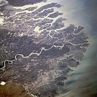
The Indus River Delta, forms where the Indus River flows into the Arabian Sea, mostly in the southern Sindh province of Pakistan with a small portion in the Kutch Region of the western tip of India. The delta covers an area of about 41,440 km2, and is approximately 210 km (130 mi) across where it meets the sea. The active part of the delta is 6,000 km2 in area (2,300 sq mi). The climate is arid, the region only receives between 25 and 50 centimetres of rainfall in a normal year. The delta is home to the largest arid mangrove forests in the world, as well as many birds, fish and the Indus dolphin.

Sukkur Barrage is a barrage on the River Indus near the city of Sukkur in the Sindh province of Pakistan. The barrage was built during the British Raj from 1923 to 1932 and was named Lloyd Barrage. The Sukkur Barrage, is the pride of Pakistan's irrigation system as it is the largest single irrigation network of its kind in the world. It irrigates from Sukkur district in the north, to Mirpurkhas/ Tharparkar and Hyderabad districts in the south of Sindh, almost all parts of the province. It is situated about 500 kilometres northeast of Karachi, 5 kilometres below the railway bridge, or the Sukkur Gorge. The introduction of barrage-controlled irrigation system resulted in more timely water supplies for the existing cultivated areas of Sindh province of Pakistan.

The Kalabagh Dam is a proposed hydroelectric dam on the Indus River at Kalabagh in the Mianwali District, Punjab, Pakistan, which has been intensely debated along ethnic and regional lines for over 40 years.

Guddu Barrage is a barrage on the Indus River near Kashmore in the Sindh province of Pakistan. President Iskander Mirza laid the foundation-stone of Guddu Barrage on 2 February 1957. The barrage was completed in 1962 at a cost of 474.8 million rupees and inaugurated by Field Marshal Ayub Khan in 1962.
Environmental issues in Pakistan include air pollution, water pollution, noise pollution, climate change, pesticide misuse, soil erosion, natural disasters, desertification and flooding. According to the latest global environment performance index (EPI) ranking Pakistan is in the list of countries which suffer from poor air quality. The climatic changes and global warming are most alarming issues risking millions of life across country. The major reasons of these environmental issues are carbon emission, increasing populations, and deforestation.
Wind power is a form of renewable energy in Pakistan which makes up more than 6% of the total electricity production in the country. As of 2018, wind power capacity in Pakistan was 1,237 MW. The government is looking to increase the share of renewable energy and plans to add around 3.5 GW of wind energy capacity by 2018.

Agriculture is considered the backbone of Pakistan's economy, which relies heavily on its major crops. Pakistan's principal natural resources are arable land and water. Agriculture accounts for about 18.9% of Pakistan's GDP and employs about 42.3% of the labour force. In Pakistan, the most agricultural province is Punjab where wheat and cotton are the most grown. Mango orchards are mostly found in Sindh and Punjab provinces that make Pakistan the world's 4th largest producer of mangoes.
Bolivia’s government considers irrigated agriculture as a major contributor to "better quality of life, rural and national development." After a period of social unrest caused by the privatization of water supply in Cochabamba and La Paz, the government of Evo Morales is undertaking a major institutional reform in the water resources management and particularly in the irrigation sector, aimed at: (i) including indigenous and rural communities in decision making, (ii) integrating technical and traditional knowledge on water resources management and irrigation, (iii) granting and registering water rights, (iv) increasing efficiency of irrigation infrastructure, (v) enhancing water quality, and (v) promoting necessary investment and financial sustainability in the sector. Bolivia is the first country in Latin America with a ministry dedicated exclusively to integrated water resources management: the Water Ministry.
Drinking water supply and sanitation in Pakistan is characterized by some achievements and many challenges. Despite high population growth the country has increased the share of the population with access to an improved water source from 85% in 1990 to 92% in 2010, although this does not necessarily mean that the water from these sources is safe to drink. The share with access to improved sanitation increased from 27% to 48% during the same period, according to the Joint Monitoring Program for Water Supply and Sanitation. There has also been considerable innovation at the grass-root level, in particular concerning sanitation. The Orangi Pilot Project in Karachi and community-led total sanitation in rural areas are two examples of such innovation.

The environmental effects of irrigation relate to the changes in quantity and quality of soil and water as a result of irrigation and the subsequent effects on natural and social conditions in river basins and downstream of an irrigation scheme. The effects stem from the altered hydrological conditions caused by the installation and operation of the irrigation scheme.

The forestry sector of Pakistan is a main source of lumber, paper, fuelwood, latex, medicine as well as food and provide ecotourism and wildlife conservation purposes. 1.91% of Pakistan's land is covered in forest.

The topography of Pakistan is divided into eight geographic areas: the northern highlands, the Indus River plain, the desert areas, the Pothohar Plateau, Balochistan Plateau, Salt Range, and the Sistan Basin. All the rivers of Pakistan, i.e. Sindh, Ravi River, Chenab River, Jhelum River, and Sutlej River, originate from the Himalayas mountain range. Some geographers designate Plateau as to the west of the imaginary southwest line; and the Indus Plain lies to the east of that line.

The Nara Canal is a deepened delta channel of the Indus River in Sindh province, Pakistan. It was built as an excavated channel stemming off the left bank of the Indus River to join the course of the old Nara River, a tributary c.q. paleochannel of the Indus which received water from the Ghaggar-Hakra until the Hakra dried-up, early 2nd millennium BCE.

Irrigation in India includes a network of major and minor canals from Indian rivers, groundwater well based systems, tanks, and other rainwater harvesting projects for agricultural activities. Of these groundwater system is the largest. In 2013-14, only about 36.7% of total agricultural land in India was reliably irrigated, and remaining 2/3rd cultivated land in India is dependent on monsoons. 65% of the irrigation in India is from groundwater. Currently about 51% of the agricultural area cultivating food grains is covered by irrigation. The rest of the area is dependent on rainfall which is most of the times unreliable and unpredictable.

Climate change in Pakistan is expected to cause wide-ranging effects on the environment and people in Pakistan. As a result of ongoing climate change, the climate of Pakistan has become increasingly volatile over the past several decades; this trend is expected to continue into the future. In addition to increased heat, drought and extreme weather conditions in some parts of the country, the melting of glaciers in the Himalayas threatens many of the most important rivers of Pakistan. Between 1999 and 2018, Pakistan was ranked the 5th worst affected country in terms of extreme climate caused by climate change.
Sindh Barrage is a proposed project in Sindh, Pakistan that will be constructed on the River Indus in between the Kotri Barrage and the Indus River outfall into the Arabian Sea.