
Hulst is a municipality and city in southwestern Netherlands in the east of Zeelandic Flanders.

Batenburg is a village in the municipality of Wijchen, in the Dutch province of Gelderland. It is located on the Meuse, about 15 km west of Nijmegen. It is well known for the remains of a medieval fort in the center of the town. The town gained cityrights in the 14th century, although it only has a population of about 650 today
Sint Willebrord is a town in the municipality of Rucphen in the Netherlands. It is also known by the name 't Heike which was the semi-official name up until 1950/1970, which is the diminutive form of hei (heath) in local dialect. This town was formed on the former boundary between the "Baronie of Breda" and "Het Markizaat of Bergen op Zoom". Sint Willebrord is the largest of the five towns in the municipality of Rucphen. During Carnaval the town goes by the name of Heikneutersland Basically meaning ´Hillbillies´ land´ or ´Redneck's land´. The name "Sint Willebrord" comes from Saint Willibrord. Sint is the usual form in Dutch names to represent saints. Cyclist Wim van Est and footballer Rini (Pallack) Konings were famous sports personalities from Sint Willebrord.
Gemert is a town in the Dutch province of North Brabant. It is located in the municipality of Gemert-Bakel.

Sint Joost is a small Dutch village in the municipality of Echt-Susteren.
Nieuwland is a former municipality in the Dutch province of Zeeland. It existed until 1816, when it was merged with Sint Joosland to form the new municipality of Nieuw- en Sint Joosland.
Sint Joosland is a former municipality in the Dutch province of Zeeland. It existed until 1816, when it was merged with Nieuwland to form the new municipality of Nieuw- en Sint Joosland. The municipality consisted of a single polder southeast of the current village of Nieuw- en Sint Joosland.
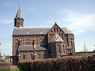
Sint Kruis is a village in the Dutch province of Zeeland. It is located about 4 km east of Aardenburg, in the municipality of Sluis.

Sint Laurens is a village in the Dutch province of Zeeland. It is located in the municipality of Middelburg, about 3 km north of the city.
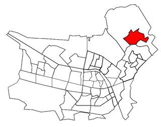
Sint Pancras is a town in the northwestern Netherlands. It is located in the municipality of Langedijk, North Holland, about 5 km northeast of Alkmaar.
Overasselt is a village in the Dutch province of Gelderland. It is located in the municipality of Heumen.

Posterholt is a village in the Dutch province of Limburg. It is located in the municipality of Roerdalen.

Roggel is a village in the Dutch province of Limburg. It is located in the municipality of Leudal.
Cuijk en Sint Agatha is a former municipality in the Dutch province of North Brabant. It covered the villages of Cuijk and Sint Agatha.

Den Dungen is a village in the Dutch province of North Brabant. It is located in the municipality of Sint-Michielsgestel next to the village Maaskantje.
Oploo, Sint Anthonis en Ledeacker was a municipality in the Dutch province of North Brabant. It was created in 1821, in a merger of Oploo and Sint Anthonis en Ledeacker. The municipality existed until 1994, when it became part of a larger municipality St. Anthonis.
Udenhout is a village and a former municipality in the Dutch province of North Brabant. It is located northeast of Tilburg, north of Berkel-Enschot and south of the National Parc Loonse en Drunense Duinen.
Sint Anthoniepolder is a small village in the Dutch province of South Holland. It is located about 14 km south of the city of Rotterdam, in the municipality of Binnenmaas.
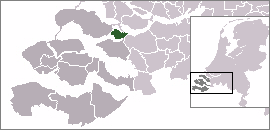
Sint Philipsland is a former island in the Dutch province of Zeeland. Nowadays it is part of the municipality of Tholen.


