| Sipaliwini River | |
|---|---|
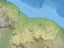
 Map of the Sipaliwini river in Suriname | |
 | |
| Location | |
| Country | Suriname |
| Physical characteristics | |
| Source | Tumuk Humak Mountains |
| • location | 1°50′42″N55°59′15″W / 1.8450°N 55.9875°W |
| Mouth | Courantyne River |
• location | 2°20′38″N56°52′18″W / 2.3439°N 56.8718°W |
| Basin features | |
| Progression | Courantyne River→Atlantic Ocean |


TheSipaliwini River (loosely translated as Spiny Ray River: sipari = thorn ray, wini = river) is a river in the south of Suriname. It gives its name to the village of Sipaliwini Savanna and to the Sipaliwini District of the same name, in the Corantijn river basin. It rises in the Sipaliwinisavanne and flows into the Coeroenie River and flows through the village of Kwamalasamutu. The name translates to thornback ray (sipari) river in the local Maroon dialect. The Sipaliwini is one of the least visited]] areas of Suriname.