
Chhattisgarh is a landlocked state in Central India. It is the ninth largest state by area, and with a population of roughly 30 million, the seventeenth most populous. It borders seven states – Uttar Pradesh to the north, Madhya Pradesh to the northwest, Maharashtra to the southwest, Jharkhand to the northeast, Odisha to the east, Andhra Pradesh and Telangana to the south. Formerly a part of Madhya Pradesh, it was granted statehood on 1 November 2000 with Raipur as the designated state capital.

The Chota Nagpur Plateau is a plateau in eastern India, which covers much of Jharkhand state as well as adjacent parts of Chhattisgarh, Odisha, West Bengal and Bihar. The Indo-Gangetic plain lies to the north and east of the plateau, and the basin of the Mahanadi river lies to the south. The total area of the Chota Nagpur Plateau is approximately 65,000 square kilometres (25,000 sq mi).

The Chhattisgarh High Court is one of the High Courts in India located at Village Bodri, Bilaspur with jurisdiction over the state of Chhattisgarh. It was established on 1 November 2000 with the creation of New state of Chhattisgarh upon the reorganisation of the state of Madhya Pradesh. The High Court of Bilaspur is the 19th High Court of India.

Dindori District, formerly known as Ramgarh District, is a district of Madhya Pradesh state of central India. The town of Dindori is the district headquarters. The district is part of Jabalpur Division. Total area of the district is 6,128 km2 (2,366 sq mi). It is located on the eastern part of Madhya Pradesh, bordering the state of Chhattisgarh. It is surrounded by Anuppur district to the northeast, Umaria district to the north, Jabalpur district to the west, Mandla district to the southwest and Mungeli and Kabirdham districts of Chhattisgarh to the south.

Koriya district, officially known as Korea district, is a district in the north-western part of the Chhattisgarh state in Central India. The administrative headquarters of the district is Baikunthpur.
Surguja district is a district of the Indian state of Chhattisgarh. The district is one of the oldest districts of Chhattisgarh. The headquarters of the district is Ambikapur.

Khariar is a city and a Notified Area Council in Nuapada District of the Indian state of Odisha.
Shivrinarayan also known as Sheorinarayan is a town and a nagar panchayat located at the Triveni Dhara of Mahanadi, Shivnath and Jonk River in Janjgir-Champa district in the Indian state of Chhattisgarh.
Dandakaranya, also rendered Dandaka, is a historical region and the name of a forest mentioned in the ancient Indian epic Ramayana. It covers about 92,200 square kilometres (35,600 sq mi) of land, which includes the Abujhmar Hills in the west and the Eastern Ghats in the east, including regions of Andhra Pradesh, Maharashtra, Chhattisgarh, Odisha and Telangana states. It spans about 300 kilometres (200 mi) from north to south and about 500 kilometres (300 mi) from east to west.
Dindori is a district of Madhya Pradesh state of central India. The town of Dindori is the district headquarters. It was created on 25th May, 1998 with total 927 villages. The district is a part of Jabalpur Division. The district covers an area of 7470 sq.km. and is located on the eastern part of Madhya Pradesh, bordering the state of Chhattisgarh. It is surrounded by Shahdol in the east, Mandla in the west, Umaria in the north, and Bilaspur district of the state of Chhattisgarh in the south. Mathematically, the district is situated between the latitudes 22.17N and 23.22N and longitudes 80.35E and 80.58E It is divided into seven blocks namely Dindori, Shahpura, Mehandwani, Amarpur, Bajag, Karanjiya and Samnapur.

Government of Chhattisgarh also known as the State Government of Chhattisgarh, or locally as State Government, is the supreme governing authority of the Indian state of Chhattisgarh and its 33 districts. It consists of an executive, led by the Governor of Chhattisgarh, a judiciary and a legislative branch.
Ramgarh district is one of the 24 districts in the Indian state of Jharkhand. It was also a military district during the British Regime, referred to then as Ramgarh district. It is the part of State Capital Region (SCR).

Moscow Architectural Institute - MArchI is a famous architecture school located in Moscow, Russia. Since 1994, the Institute has been accredited by the Royal Institute of British Architects.

Tourism is an important part of the economy of the Indian state of Chhattisgarh, India's tenth largest state. The state has many ancient monuments, rare wildlife, carved temples, Buddhist sites, palaces, water falls, caves, rock paintings and hill plateaus.
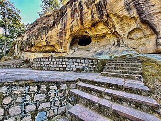
Ramgarh is a village in Chhattisgarh, India; the nearest large town is Ambikapur. The Ramgarh hills are nearby. Famous Jogimara and Sitabenga Caves are situated in these hills.
Ramgarh is a medium size village in Phillaur tehsil of Jalandhar District of Punjab State, India. It is located 1 km away from postal head office Phillaur, 16 km from Ludhiana, 45 km from district headquarter Jalandhar and 118 km from state capital Chandigarh. The village is administrated by a sarpanch who is an elected representative of village as per Panchayati raj (India).

The Barkakana–Muri–Chandil line is an Indian railway line connecting Barkakana and Muri with Chandil on the Asansol–Tatanagar–Kharagpur line. This 126-kilometre (78 mi) track is under the jurisdiction of South Eastern Railway.

The Sitabenga and Jogimara Caves, sometimes referred to either as Sitabenga Cave or Jogimara Cave, are ancient cave monuments nested in the north side of Ramgarh hills in Puta village, Chhattisgarh, India. Dated between the 3rd-century BCE to 1st-century BCE, they are notable for their non-religious inscriptions in Brahmi script and Magadhi language, and one of the oldest colored frescoes in Asia. Some scholars state that the Sitabenga cave is the oldest performance theatre on the Indian subcontinent, but others question whether it was indeed a theatre and suggest that it may have been a resting place (dharmashala) along an ancient trade route. The inscription at the Jogimara cave is equally disputed, with one translation interpreting it as a love-graffiti by a girl and a boy, while another translation interpreting it as a female dancer and a male sculptor-painter creating the two caves together to serve others. The inscription is also the oldest known mention of the word "devadasi", but this seems just a name and it is unlikely that this was related to any ancient Indian temple since the site and nearby area has no evidence of any Buddhist, Hindu or Jain temple built between the 3rd-century BCE and 8th-century CE.
Ram Van Gaman Path is the path that Lord Rama, Sita and Lakshmana took during their 'vanvaas' or exile years. It starts from Ayodhya and ends at Sri Lanka. This path is much revered in the Hindu religion as various key incidents of Lord Rama’s life have taken place on this path.