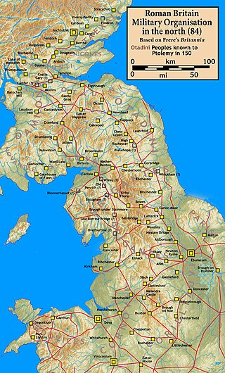
Watling Street is a historic route in England that crosses the River Thames at London and which was used in Classical Antiquity, Late Antiquity, and throughout the Middle Ages. It was used by the ancient Britons and paved as one of the main Roman roads in Britannia. The route linked Dover and London in the southeast, and continued northwest via St Albans to Wroxeter. The line of the road was later the southwestern border of the Danelaw with Wessex and Mercia, and Watling Street was numbered as one of the major highways of medieval England.
Ermine Street is a major Roman road in England that ran from London (Londinium) to Lincoln and York (Eboracum). The Old English name was Earninga Strǣt (1012), named after a tribe called the Earningas, who inhabited a district later known as Armingford Hundred, around Arrington, Cambridgeshire, and Royston, Hertfordshire. "Armingford", and "Arrington" share the same Old English origin. The original Celtic and Roman names for the route remain unknown. It is also known as the Old North Road from London to where it joins the A1 Great North Road near Godmanchester.

The Fosse Way was a Roman road built in Britain during the first and second centuries AD that linked Isca Dumnoniorum (Exeter) in the southwest and Lindum Colonia (Lincoln) to the northeast, via Lindinis (Ilchester), Aquae Sulis (Bath), Corinium (Cirencester), and Ratae Corieltauvorum (Leicester).
Castle Hill may refer to:

The Iceni or Eceni were an ancient tribe of eastern Britain during the Iron Age and early Roman era. Their territory included present-day Norfolk and parts of Suffolk and Cambridgeshire, and bordered the area of the Corieltauvi to the west, and the Catuvellauni and Trinovantes to the south. In the Roman period, their capital was Venta Icenorum at modern-day Caistor St Edmund.

Thetford is a market town and civil parish in the Breckland District of Norfolk, England. It is on the A11 road between Norwich and London, just east of Thetford Forest. The civil parish, covering an area of 29.55 km2 (11.41 sq mi), in 2011 had a population of 24,340.

Roman roads in Britannia were initially designed for military use, created by the Roman army during the nearly four centuries (AD 43–410) that Britannia was a province of the Roman Empire.
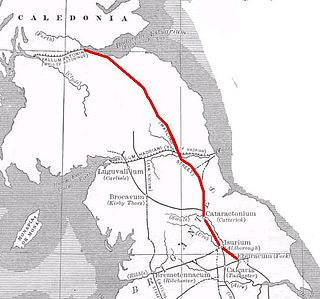
Dere Street or Deere Street is a modern designation of a Roman road which ran north from Eboracum (York), crossing the Stanegate at Corbridge and continuing beyond into what is now Scotland, later at least as far as the Antonine Wall. Portions of its route are still followed by modern roads, including the A1(M), the B6275 road through Piercebridge, where Dere Street crosses the River Tees, and the A68 north of Corbridge in Northumberland.

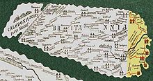
The Antonine Itinerary is an itinerarium, a register of the stations and distances along various roads. Seemingly based on official documents, possibly from a survey carried out under Augustus, it describes the roads of the Roman Empire. Owing to the scarcity of other extant records of this type, it is a valuable historical record.

Aldringham cum Thorpe is a civil parish in the East Suffolk district of Suffolk, England. Located south of the town of Leiston, the parish includes the villages of Aldringham and Thorpeness, which is on the coast, between Sizewell (north) and Aldeburgh (south). In 2007 it had an estimated population of 700, rising to 759 at the 2011 Census.

Brandon is a town and civil parish in the English county of Suffolk. Brandon is located in the Breckland area of Suffolk, close to the adjoining county of Norfolk. It lies between the towns of Bury St Edmunds, Thetford, Mildenhall, Downham Market and the city of Ely. It lies next to Thetford Forest Park.

Venta Icenorum was the civitas or capital of the Iceni tribe, located at modern-day Caistor St Edmund in the English county of Norfolk. The Iceni inhabited the flatlands and marshes of that county and are famous for having revolted against Roman rule under their queen Boudica in the winter of AD 61.
Blestium was a small fort and iron working centre in the Roman province of Britannia Superior, part of Roman Britain. It has been identified with the site of the later town of Monmouth in south east Wales, located adjoining the confluence of the River Monnow with the River Wye. A plaque on the local bank records its position.

Thomas Martin, known as "Honest Tom Martin of Palgrave", was an antiquarian and lawyer.

Little Thetford is a small village in the civil parish of Thetford, 3 miles (5 km) south of Ely in Cambridgeshire, England, about 76 miles (122 km) by road from London. The village is built on a boulder clay island surrounded by flat fenland countryside, typical of settlements in this part of the East of England.
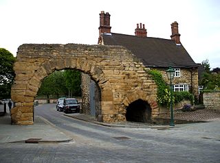
Cataractonium was a fort and settlement in Roman Britain. The settlement evolved into Catterick, located in North Yorkshire, England.
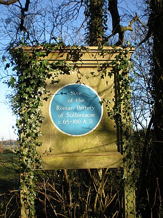
Sulloniacis or Sulloniacae was a mansio on the Roman road known as Watling Street in Roman Britain. Its existence is known from only one entry in the Antonine Itinerary, a listing of routes and facilities for the cursus publicus, the official courier service of the Roman Empire. Sulloniacis, which is recorded in Iter II for the route that ran between Portus Ritupis and Deva Victrix, was nine Roman miles from Verulamium and 12 from Londinium (London). Roman remains found at Brockley Hill near Edgware in the London Borough of Barnet have been identified as those of Sulloniacis.
Blatobulgium was a Roman fort, located at the modern-day site known as Birrens, in Dumfriesshire, Scotland.
Caenophrurium was a settlement in the Roman province of Europa, between Byzantium and Heraclea Perinthus. It appears in late Roman and early Byzantine accounts. Caenophrurium translates as the "stronghold of the Caeni", a Thracian tribe.
Mopsucrene or Mopsoukrene was a town in the eastern part of ancient Cilicia, on the river Cydnus, and not far from the frontier of Cataonia to which Ptolemy, in fact, assigns it. Its site was on the southern slope of Mount Taurus, and in the neighbourhood of the mountain pass leading from Cilicia into Cappadocia, 12 miles (19 km) north of Tarsus.