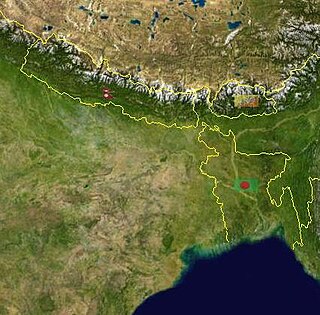
Siwalik is a highland region between the Mahabharat and Chure mountain ranges in Nepal.
The region has huge deposits of calcium carbonate and of important minerals such as iron, sulfur, and copper; the deposits however, are generally of sub-economic grades that currently are not worth exploiting. The Siwalik Hills are regarded as the most tectonically dynamic zone of the Himalaya, the region's altitude increasing at a rate of 3mm to 4mm per year. This is consistent with a rate of upward expansion of kilometres per million years, which in turn implies that the formation is geologically young and tectonically exceptionally active; the substance of the terrain is accordingly crumbly. The hills extend in a narrow east-west belt, only some 15–20km in width, which marks the northern boundary of the plains of Terai and the southern boundary of Middle-hill Mountains.
The region is important for two reasons in particular. Firstly, it is the prime source of sediments for the plain of Terai — torrents flowing down the steep gradients erode material from the fragile rock and transport it downstream. The streams slow down as they flow onto the plain, and in consequence they deposit their burden of silt, thereby filling or clogging the streambeds and raising their levels. This aggravates flooding problems in the plains. On the credit side however, the silt replenishes the nutrient content of the soil of the downstream lowland plains, which produce more than 80% of Nepal's agricultural food supply.
The second important aspect of the significance of the Siwalik region and associated concerns, is that it supports dense sub-tropical forest. Deforestation is increasing in consequence of demands for timber, firewood and litter from the local population. In spite of its protective cover of vegetation, the Siwalik is subject to severe erosion that creates gullies and promotes landslides. This is partly because of the crumbly texture of its pedology and partly because of the intensity of the regional rainfall. The effects of tectonic uplifting may also contribute to the problem, but studies to establish their contribution currently are inadequate. The erosion is of primary concern, both as the main source of sediments and of associated hazards such as debris flow, and the progression of erosion is accelerating the decrease and degradation of the forest resources.
Siwalik rocks are the upper tertiary rocks which are exposed in himalayan foothill zone extending from hardwar in UP to Assam. These are also described as Siwalik group
Related Research Articles
Nepal measures about 880 kilometers (547 mi) along its Himalayan axis by 150 to 250 kilometers across. It has an area of 147,516 km2 (56,956 sq mi).
Sedimentary rocks are types of rock that are formed by the accumulation or deposition of mineral or organic particles at Earth's surface, followed by cementation. Sedimentation is the collective name for processes that cause these particles to settle in place. The particles that form a sedimentary rock are called sediment, and may be composed of geological detritus (minerals) or biological detritus. The geological detritus originated from weathering and erosion of existing rocks, or from the solidification of molten lava blobs erupted by volcanoes. The geological detritus is transported to the place of deposition by water, wind, ice or mass movement, which are called agents of denudation. Biological detritus was formed by bodies and parts of dead aquatic organisms, as well as their fecal mass, suspended in water and slowly piling up on the floor of water bodies. Sedimentation may also occur as dissolved minerals precipitate from water solution.
Landforms are categorized by characteristic physical attributes such as their creating process, shape, elevation, slope, orientation, rock exposure, and soil type.
The Interior Plains are a vast physiographic region that spreads across the Laurentian craton of central North America, extending along the east flank of the Rocky Mountains from the Gulf Coast region to the Arctic Beaufort Sea. In Canada, it encompasses the Canadian Prairies separating the Canadian Rockies from the Canadian Shield, as well as the Boreal Plains and Taiga Plains east of the Mackenzie and Richardson Mountains; while in the United States, it includes the Great Plains of the West/Midwest and the tallgrass prairie region to the south of the Great Lakes extending east to the Appalachian Plateau region.
The Los Angeles Basin is a sedimentary basin located in Southern California, in a region known as the Peninsular Ranges. The basin is also connected to an anomalous group of east-west trending chains of mountains collectively known as the Transverse Ranges. The present basin is a coastal lowland area, whose floor is marked by elongate low ridges and groups of hills that is located on the edge of the Pacific Plate. The Los Angeles Basin, along with the Santa Barbara Channel, the Ventura Basin, the San Fernando Valley, and the San Gabriel Basin, lies within the greater southern California region.
The Sivalik Hills, also known as the Shivalik Hills and Churia Hills, are a mountain range of the outer Himalayas that stretches over about 2,400 km (1,500 mi) from the Indus River eastwards close to the Brahmaputra River, spanning across the northern parts of the Indian subcontinent. It is 10–50 km (6.2–31.1 mi) wide with an average elevation of 1,500–2,000 m (4,900–6,600 ft). Between the Teesta and Raidāk Rivers in Assam is a gap of about 90 km (56 mi). "Sivalik" literally means 'tresses of Shiva'. Sivalik region is home to the Soanian archaeological culture.
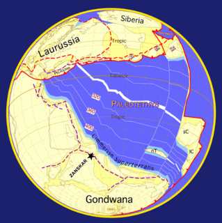
The geology of the Himalayas is a record of the most dramatic and visible creations of the immense mountain range formed by plate tectonic forces and sculpted by weathering and erosion. The Himalayas, which stretch over 2400 km between the Namcha Barwa syntaxis at the eastern end of the mountain range and the Nanga Parbat syntaxis at the western end, are the result of an ongoing orogeny — the collision of the continental crust of two tectonic plates, namely, the Indian Plate thrusting into the Eurasian Plate. The Himalaya-Tibet region supplies fresh water for more than one-fifth of the world population, and accounts for a quarter of the global sedimentary budget. Topographically, the belt has many superlatives: the highest rate of uplift, the highest relief, among the highest erosion rates at 2–12 mm/yr, the source of some of the greatest rivers and the highest concentration of glaciers outside of the polar regions. This last feature earned the Himalaya its name, originating from the Sanskrit for "the abode of the snow".
The Terai or Tarai is a lowland region in northern India and southern Nepal that lies south of the outer foothills of the Himalayas, the Sivalik Hills, and north of the Indo-Gangetic Plain. This lowland belt is characterised by tall grasslands, scrub savannah, sal forests and clay rich swamps. In northern India, the Terai spreads from the Yamuna River eastward across Haryana, Uttarakhand, Uttar Pradesh, Bihar and West Bengal. The Terai is part of the Terai-Duar savanna and grasslands ecoregion. The corresponding lowland region in West Bengal, Bangladesh, Bhutan and Assam in the Brahmaputra River basin is called 'Dooars'. In Nepal, the term is applied to the part of the country situated north of the Indo-Gangetic Plain. Nepal's Terai stretches over 33,998.8 km2 (13,127.0 sq mi), about 23.1% of Nepal's land area, and lies at an elevation of between 67 and 300 m. The region comprises more than 50 wetlands. North of the Terai rises the Bhabar, a narrow but continuous belt of forest about 8–12 km (5.0–7.5 mi) wide.
Mudrocks are a class of fine-grained siliciclastic sedimentary rocks. The varying types of mudrocks include siltstone, claystone, mudstone, slate, and shale. Most of the particles of which the stone is composed are less than 1⁄16 mm and are too small to study readily in the field. At first sight, the rock types appear quite similar; however, there are important differences in composition and nomenclature.
Geography of West Bengal, a state in eastern India, is diverse, of high peaks of Himalaya in the northern extremes to where Himalayas are in the north and sea is at the south, with both plains and plateaus covering the remaining region.
The geology of Nepal is dominated by the Himalaya, the highest, youngest and a very highly active mountain range. Himalaya is a type locality for the study of on-going continent-continent collision tectonics. The Himalayan arc extends about 2,400 km (1,500 mi) from Nanga Parbat by the Indus River in northern Pakistan eastward to Namche Barwa by the gorge of the Tsangpo-Brahmaputra in eastern Tibet. About 800 km (500 mi) of this extent is in Nepal; the remainder includes Bhutan and parts of Pakistan, India, and China.
Kaziranga National Park is an Indian national park and a World Heritage Site in Golaghat and Nagaon districts of Assam, India. It is refuge for the world's largest population of Great One-horned Rhinoceros. The park has many Elephant, Water Buffalo and Swamp Deer. It is recognized as an Important Bird Area by Birdlife International for conservation of avifaunal species. The park has achieved notable progress in wildlife conservation despite several constraints.
The Soanian culture is a prehistoric technological culture from the Siwalik Hills in the Indian subcontinent. It is named after the Soan Valley in Pakistan. Soanian sites are found along the Siwalik region in present-day India, Nepal and Pakistan. The Soanian culture has been approximated to have taken place during the Middle Pleistocene period or the mid-Holocene period. Debates still goes on today regarding the exact period occupied by the culture due to artefacts often being found in non-datable surface context. This culture was first discovered and named by the anthropology and archaeology team led by Helmut De Terra and Thomas Thomson Paterson. Soanian artifacts were manufactured on quartzite pebbles, cobbles, and occasionally on boulders, all derived from various fluvial sources on the Siwalik landscape. Soanian assemblages generally comprise varieties of choppers, discoids, scrapers, cores, and numerous flake type tools, all occurring in varying typo-technological frequencies at different sites.
The geology of Kansas encompasses the geologic history and the presently exposed rock and soil. Rock that crops out in the US state of Kansas was formed during the Phanerozoic eon, which consists of three geologic eras: the Paleozoic, Mesozoic and Cenozoic. Paleozoic rocks at the surface in Kansas are primarily from the Mississippian, Pennsylvanian, and Permian periods.
The Inner Terai Valleys of Nepal comprise several elongated river valleys in the southern lowland Terai part of the country. These tropical valleys are enclosed by the Himalayan foothills, viz the Mahabharat Range and the Sivalik Hills farther south.
Bihar is located in the eastern region of India, between latitudes 24°20'10"N and 27°31'15"N and longitudes 83°19'50"E and 88°17'40"E. It is an entirely land–locked state, in a subtropical region of the temperate zone. Bihar lies between the humid West Bengal in the east and the sub humid Uttar Pradesh in the west, which provides it with a transitional position in respect of climate, economy and culture. It is bounded by Nepal in the north and by Jharkhand in the south. Bihar plain is divided into two unequal halves by the river Ganges which flows through the middle from west to east. Bihar's land has average elevation above sea level of 173 feet.
A bedrock river is a river that has little to no alluvium mantling the bedrock over which it flows. However, most bedrock rivers are not pure forms; they are a combination of a bedrock channel and an alluvial channel. The way one can distinguish between bedrock rivers and alluvial rivers is through the extent of sediment cover.
The ecology of the Himalayas varies with climate, rainfall, altitude, and soils. The climate ranges from tropical at the base of the mountains to permanent ice and snow at the highest elevations. The amount of yearly rainfall increases from west to east along the southern front of the range. This diversity of climate, altitude, rainfall and soil conditions supports a variety of distinct plant and animal species, such as the Nepal gray langur
The Himalayan foreland basin is an active collisional foreland basin system in South Asia. Uplift and loading of the Eurasian Plate on to the Indian Plate resulted in the flexure (bending) of the Indian Plate, and the creation of a depression adjacent to the Himalayan mountain belt. This depression was filled with sediment eroded from the Himalaya, that lithified and produced a sedimentary basin ~3 to >7 km deep. The foreland basin spans approximately 2,000 kilometres (1,200 mi) in length and 450 kilometres (280 mi) in width. From west to east the foreland basin stretches across five countries: Pakistan, India, Nepal, Bangladesh, and Bhutan.
The geology of Himachal Pradesh is dominated by Precambrian rocks that were assembled and deformed during the India-Asia collision and the subsequent Himalayan orogeny. The Northern Indian State Himachal Pradesh is located in the Western Himalaya. It has a rugged terrain, with elevation ranging from 320m to 6975m. Rock materials in the region are largely from the Indian craton, and their ages range from the Paleoproterozoic to the present day. It is generally agreed that the Indian craton collided with Asia 50-60 million years ago (Ma). Rock sequences were thrust and folded immensely during the collision. The area has also been shaped by focused orographic precipitation, glaciation and rapid erosion.
This page is based on this Wikipedia article Text is available under the CC BY-SA 4.0 license; additional terms may apply. Images, videos and audio are available under their respective licenses.