The Six Hills are a collection of Romanbarrows situated alongside the old Great North Road on Six Hills Common in Stevenage, Hertfordshire, England. They are classed as a Scheduled Ancient Monument and are protected by law. They form the largest surviving Roman barrow group in England. Beside their historical significance, they lend their name to an important thoroughfare in the town (Six Hills Way) and are a local landmark.
History
For almost two thousand years, travellers along the Roman road that eventually became the Great North Road have passed these six large mounds. Their origin and purpose has been the subject of much speculation.
Local legend holds that they were the work of the Devil, who, sitting one day looking down on the Great North Road, began to amuse himself by heaving clods of earth at the passers-by. He missed six times and in a temper threw a seventh clod over his shoulder, hitting the spire of Graveley church and knocking it askew. The spire is crooked to this day. The holes in Whomerley Wood show where the Devil dug out his missiles, and the six failed shots lie in a line alongside the road and form the Six Hills.
The Six Hills are almost certainly Roman burial mounds, dating from about 100 A.D., and probably mark the cremated remains of a wealthy local family. The ashes would have been placed in a container along with objects for use in the next world.
No recent scientific archaeological excavation has been carried out on the Hills, but they have all been dug into in the past. These early investigations found only "...a few pieces of wood and a piece of iron...", which were dismissed at the time, but probably were the remains of the original burials. Other reports of damage include the farmer who was carting soil away from the Hills in 1750, and an attempted widening of the Great North Road in about 1820. Over the years, the Hills have all lost over 4 feet (1.2m) in height.
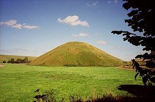
Stonehenge is a prehistoric megalithic structure on Salisbury Plain in Wiltshire, England, two miles (3 km) west of Amesbury. It consists of an outer ring of vertical sarsen standing stones, each around 13 feet (4.0 m) high, seven feet (2.1 m) wide, and weighing around 25 tons, topped by connecting horizontal lintel stones. Inside is a ring of smaller bluestones. Inside these are free-standing trilithons, two bulkier vertical sarsens joined by one lintel. The whole monument, now ruinous, is aligned towards the sunrise on the summer solstice and sunset on the winter solstice. The stones are set within earthworks in the middle of the densest complex of Neolithic and Bronze Age monuments in England, including several hundred tumuli.
Brighton and Hove is a unitary authority with city status in East Sussex, England. There are multiple villages alongside the seaside resorts of Brighton and Hove in the district. It is administered by Brighton and Hove City Council, which is currently under Labour majority control.
Silbury Hill is a prehistoric artificial chalk mound near Avebury in the English county of Wiltshire. It is part of the Stonehenge, Avebury and Associated Sites UNESCO World Heritage Site. At 39.3 metres (129 ft) high, it is the tallest prehistoric human-made mound in Europe and one of the largest in the world; similar in volume to contemporary Egyptian pyramids.
Great and Little Kimble cum Marsh is a civil parish in central Buckinghamshire, England. It is located 5 miles (8 km) to the south of Aylesbury. The civil parish altogether holds the ancient ecclesiastical villages of Great Kimble, Little Kimble, Kimblewick and Marsh, and an area within Great Kimble called Smokey Row. The two separate parishes with the same name were amalgamated in 1885, but kept their separate churches, St Nicholas for Great Kimble on one part of the hillside and All Saints for Little Kimble on other side at the foot of the hill.
A tumulus is a mound of earth and stones raised over a grave or graves. Tumuli are also known as barrows, burial mounds or kurgans, and may be found throughout much of the world. A cairn, which is a mound of stones built for various purposes, may also originally have been a tumulus.
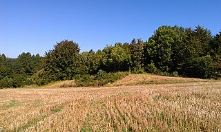
Chestnuts Long Barrow, also known as Stony Warren or Long Warren, is a chambered long barrow near the village of Addington in the south-eastern English county of Kent. Probably constructed in the fifth millennium BC, during Britain's Early Neolithic period, today it survives only in a ruined state.
Addington Long Barrow is a chambered long barrow located near the village of Addington in the southeastern English county of Kent. Probably constructed in the fourth millennium BCE, during Britain's Early Neolithic period, today it survives only in a ruined state. Built of earth and about fifty local sarsen megaliths, the long barrow consisted of a sub-rectangular earthen tumulus enclosed by kerb-stones. Collapsed stones on the northeastern end of the chamber probably once formed a stone chamber in which human remains might have been deposited, though none have been discovered.
Julliberrie's Grave, also known as The Giant's Grave or The Grave, is an unchambered long barrow located near to the village of Chilham in the south-eastern English county of Kent. Probably constructed in the fourth millennium BCE, during Britain's Early Neolithic period, today it survives only in a state of ruin.
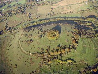
Chanctonbury Ring is a prehistoric hill fort atop Chanctonbury Hill on the South Downs, on the border of the civil parishes of Washington and Wiston in the English county of West Sussex. A ridgeway, now part of the South Downs Way, runs along the hill. It forms part of an ensemble of associated historical features created over a span of more than 2,000 years, including round barrows dating from the Bronze Age to the Saxon periods and dykes dating from the Iron Age and Roman periods.
Barnack is a village and civil parish in the Peterborough unitary authority of the ceremonial county of Cambridgeshire, England and the historic county of Northamptonshire. Barnack is in the north-west of the unitary authority, 3.5 miles (5.6 km) south-east of Stamford, Lincolnshire. The parish includes the hamlet of Pilsgate about 1 mile (1.6 km) northwest of Barnack. Both Barnack and Pilsgate are on the B1443 road. The 2011 Census recorded a parish population of 931.
The Snape Anglo-Saxon Cemetery is a place of burial dated to the 6th century AD located on Snape Common, near to the town of Aldeburgh in Suffolk, Eastern England. Dating to the early part of the Anglo-Saxon Era of English history, it contains a variety of different forms of burial, with inhumation and cremation burials being found in roughly equal proportions. The site is also known for the inclusion of a high status ship burial. A number of these burials were included within burial mounds.
Newtimber is a small village and civil parish in the Mid Sussex District of West Sussex, England. It is located north-west of Brighton. The parish also includes the hamlet of Saddlescombe. The parish lies almost wholly with the South Downs National Park, with the exception of a small section of the parish north of the B2117 road. The planning authority for Newtimber is therefore the South Downs National Park Authority (SDNPA), the statutory planning authority for the National Park area. The downland scarp, which includes Newtimber Hill, Newtimber Holt, Saddlescombe chalk quarry and Summer Down, is mostly part of the Beeding Hill to Newtimber Hill, designated Site of Special Scientific Interest.
Poynings is a village and civil parish in the Mid Sussex District of West Sussex, England. The parish lies wholly with the South Downs National Park. To its south is Brighton and Hove, to its west is the Fulking parish, to its east is the Newtimber parish and to its north is Albourne parish. The planning authority for Poynings is the South Downs National Park Authority (SDNPA), the statutory planning authority for the National Park area.
Fleam Dyke is a linear earthwork between Fulbourn and Balsham in Cambridgeshire, initiated at some timepoint between AD 330 and AD 510. It is three miles long and seven metres high from ditch to bank, and its ditch faces westwards, implying invading Saxons as its architects. Later, it formed a boundary of the Anglo-Saxon administrative division of Flendish Hundred. At a prominent point, the earthwork runs beside Mutlow Hill, crowned by a 4000-year-old Bronze Age burial mound.
Banstead Downs is a 126.7-hectare (313-acre) biological Site of Special Scientific Interest in Banstead in Surrey. There are Saxon burial mounds on the site and they are a Scheduled Monument Today, with wooded areas and wide open fields, Banstead Downs are predominantly used for walks by local residents. The downs also form a pathway from Belmont Village and Brighton Road to Banstead.
St. Catherine's Hill is a chalk downland hill and 43-hectare (110-acre) biological Site of Special Scientific Interest on the outskirts of Winchester in Hampshire, England. It is owned by Winchester College but open to the public. It is managed by Hampshire and Isle of Wight Wildlife Trust, and topped by an Iron Age hillfort, a scheduled monument. In the Black Death, plague pits were dug in the dry valley on the south side of the hill. In the Early modern period, a mizmaze was cut on the hilltop. Winchester College football used to be played on the hill; in an old custom, members of the college assemble on the hill every year, early in the morning.
The Taplow Barrow is an early medieval burial mound in Taplow Court, an estate in the south-eastern English county of Buckinghamshire. Constructed in the seventh century, when the region was part of an Anglo-Saxon kingdom, it contained the remains of a deceased individual and their grave goods, now mostly in the British Museum. It is often referred to in archaeology as the Taplow burial.
Ashdown Forest contains a wealth of archeological features. Absence of ploughing, predominance of heathland and lack of building development have allowed archaeological sites to survive and remain visible. More than 570 such sites have been identified, including Bronze Age round barrows, Iron Age enclosures, prehistoric field systems, iron workings from Roman times onwards, the Pale, medieval and post-medieval pillow mounds for the rearing of rabbits, and a set of military kitchen mounds between Camp Hill and Nutley dating from 1793 that are among the only surviving ones in the United Kingdom. The earliest known trace of human activity in Ashdown Forest is a stone hand axe found near Gills Lap, which is thought to be about 50,000 years old. The vast majority of finds however date from the Mesolithic and onwards into the modern era.
Knap Hill lies on the northern rim of the Vale of Pewsey, in northern Wiltshire, England, about a mile north of the village of Alton Priors. At the top of the hill is a causewayed enclosure, a form of Neolithic earthwork that was constructed in England from about 3700 BC onwards, characterized by the full or partial enclosure of an area with ditches that are interrupted by gaps, or causeways. Their purpose is not known: they may have been settlements, or meeting places, or ritual sites of some kind. The site has been scheduled as an ancient monument.
Shrewsbury Barrow is a Bronze Age burial mound in Shooter's Hill in South East London, in the Royal Borough of Greenwich. It is a Scheduled Monument.
This page is based on this Wikipedia article Text is available under the CC BY-SA 4.0 license; additional terms may apply. Images, videos and audio are available under their respective licenses.