Skarpnäcks gård

Last updated
Skarpnacks gard Pilotgatan 2008.jpg
Skarpnäcks gård

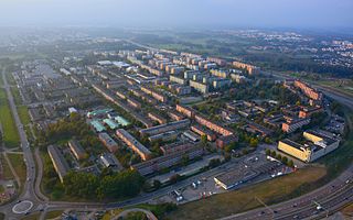
Skarpnäcks gård is a district (Swedish : stadsdel) in Skarpnäck in Stockholm Municipality, Sweden. [1] Skarpnäcks Gård has 10,348 inhabitants as of December 31, 2007. [2] [3]

Swedish language North Germanic language spoken in Sweden

Swedish is a North Germanic language spoken natively by 9.6 million people, predominantly in Sweden, and in parts of Finland, where it has equal legal standing with Finnish. It is largely mutually intelligible with Norwegian and to some extent with Danish, although the degree of mutual intelligibility is largely dependent on the dialect and accent of the speaker. Both Norwegian and Danish are generally easier for Swedish speakers to read than to listen to because of difference in accent and tone when speaking. Swedish is a descendant of Old Norse, the common language of the Germanic peoples living in Scandinavia during the Viking Era. It has the most speakers of the North Germanic languages.

Skarpnäck (borough) Borough of Stockholm in Sweden

Skarpnäck is a borough (stadsdelsområde) in the southern part of Stockholm, Sweden.

Stockholm Municipality Municipality in Stockholm County, Sweden

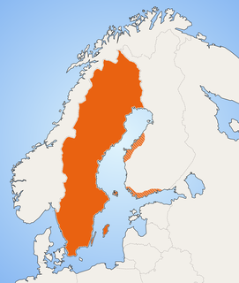
Stockholm Municipality or the City of Stockholm is a municipality in Stockholm County in east central Sweden. It has the largest population of the 290 municipalities of the country, but one of the smallest areas, making it the most densely populated. It is also the most populous municipality in the Nordic countries.

The district was formed in 1963, but the name Skarpnäcks gård has not entered common usage for the area, instead a mixture of the previous district names is used. The Stockholm Municipality and the Police among others present the statistics for the district in two separate parts, one set for the subdistrict Skarpnäcksfältet, and another for the subdistrict Pungpinan.

Skarpnäcksfältet Subdistrict of Stockholm in Södermanland, Sweden

Skarpnäcksfältet is a subdistrict of Skarpnäcks Gård in the Skarpnäck borough of Stockholm, Sweden. Skarpnäcksfältet was built in the 1980s, and has 8,734 inhabitants as of December 31, 2009.

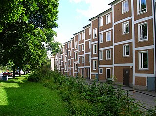
Pungpinan is a small subdistrict of Skarpnäcks Gård in Skarpnäck borough in Stockholm that consists mostly of detached houses.

Related Research Articles

Rinkeby urban district in Stockholm, Sweden

Rinkeby is a district in the Rinkeby-Kista borough, Stockholm, Sweden. Rinkeby had 19,349 inhabitants in 2016. The neighbourhood was part of the Million Programme.

Stockholm City Centre is the city centre of Stockholm in Sweden. The entire city of Stockholm is also the centre of the Stockholm Metropolitan Area.

Söderort all urban districts south of Årstaviken, Stockholm, Sweden

Söderort is the southern suburban part of the Stockholm Municipality, Sweden. It is also part of the city of Stockholm.

Västerort is the western part of Stockholm Municipality in Stockholm County, Sweden. It also forms part of Stockholm urban area and of Stockholm Metropolitan Area. It constitutes the western suburban area within Stockholm's municipal borders.

Bagarmossen District of Stockholm in Södermanland, Sweden

Bagarmossen is a district within Skarpnäck borough of Stockholm, Sweden. Bagarmossen had 10,951 inhabitants as of December 31, 2009.

Akalla urban district in Stockholm, Sweden

Akalla is a district in Rinkeby-Kista borough, Stockholm, Sweden. Akalla has 8,153 inhabitants as of December 31, 2007, in which immigrants, mostly from Iran, make up 64% of the population.

Tensta Place in Stockholm, Sweden

Tensta is a district in Spånga-Tensta borough, Stockholm, Sweden. There are about 6,000 apartments in Tensta and a population of 17,083 as of December 31, 2007.

Hammarbyhöjden urban district in Stockholm, Sweden

Hammarbyhöjden is a suburban city district in Stockholm, Sweden. The district is split across two boroughs: Most of it is located in Skarpnäck borough, the subdistrict Blåsut is located in the Enskede-Årsta-Vantör borough. As of December 31, 2007, Hammarbyhöjden had 8,143 inhabitants.

Hökarängen urban district in Stockholm, Sweden

Hökarängen is a district in the Farsta borough of southern Stockholm. It neighbours Fagersjö to the west, Farsta to the south, Sköndal to the east and Gubbängen to the north. As of December 31, 2012, the total population of Hökarängen is 8,916.

Björkhagen urban district in Stockholm, Sweden

Björkhagen is a district in Skarpnäck borough, Stockholm, Sweden. Björkhagen has 5,695 inhabitants as of December 31, 2007.

Rinkeby-Kista Borough of Stockholm in Stockholm Municipality, Sweden

Rinkeby-Kista is a borough (stadsdelsområde) in Stockholm, Sweden. The borough is located in Västerort.

Husby, Stockholm urban district in Stockholm, Sweden

Husby is a district in Rinkeby-Kista borough, Stockholm, Sweden. Husby has 11,551 inhabitants as of December 31, 2007.

Kärrtorp District of Stockholm in Södermanland, Sweden

Kärrtorp is a district in the Skarpnäck borough of Stockholm, Sweden,. Kärrtorp has 4,296 inhabitants as of December 31, 2009.

Enskededalen urban district in Stockholm, Sweden

Enskededalen, commonly referred to as "Dalen", is a district in Skarpnäck borough, Stockholm, Sweden. Enskededalen has 2,253 inhabitants as of December 31, 2007.

Flaten is a district in Skarpnäck borough, Stockholm, Sweden. Flaten has 8 inhabitants as of December 31, 2006.

Orhem urban district in Stockholm, Sweden

Orhem is a district in Skarpnäck borough, Stockholm, Sweden. Orhem has 82 inhabitants as of December 31, 2006.

Skrubba is a district in Skarpnäck borough, Stockholm, Sweden. Skrubba has 19 inhabitants as of December 31, 2007.

Sköndal urban district in Stockholm, Sweden

Sköndal (Fairvale) is a district in the Farsta borough of southern Stockholm. It neighbours Gubbängen to the northwest, Hökarängen to the west, Farsta to the southwest and Larsboda to the south. To the east and partially north it neighbours the Skarpnäck borough, in particular the districts of Skarpnäcks Gård and Orhem. As of December 31, 2008, the total population of Sköndal is 7,450.

References

  1. "Administrative divisions of the City districts". Stockholms stads utrednings- och statistikkontor AB. 2008-04-14. Retrieved 2008-06-03.
  2. "Områdesfakta delområde Skarpnäcksfältet". Stockholms stads utrednings- och statistikkontor AB. 2007-12-31. Retrieved 2008-06-08.
  3. "Områdesfakta delområde Pungpinan". Stockholms stads utrednings- och statistikkontor AB. 2007-12-31. Retrieved 2008-06-08.

Coordinates: 59°16′1.55″N18°8′12.04″E / 59.2670972°N 18.1366778°E / 59.2670972; 18.1366778

Geographic coordinate system Coordinate system

A geographic coordinate system is a coordinate system that enables every location on Earth to be specified by a set of numbers, letters or symbols. The coordinates are often chosen such that one of the numbers represents a vertical position and two or three of the numbers represent a horizontal position; alternatively, a geographic position may be expressed in a combined three-dimensional Cartesian vector. A common choice of coordinates is latitude, longitude and elevation. To specify a location on a plane requires a map projection.