
Merseyside is a metropolitan county in North West England, with a population of 1.38 million. It encompasses the metropolitan area centred on both banks of the lower reaches of the Mersey Estuary and comprises five metropolitan boroughs: Knowsley, St Helens, Sefton, Wirral, and the city of Liverpool. Merseyside, which was created on 1 April 1974 as a result of the Local Government Act 1972, takes its name from the River Mersey.
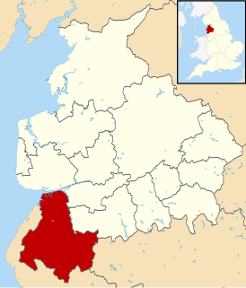
West Lancashire is a non-metropolitan district with the status of a borough in Lancashire, England. Its council is based in Ormskirk. The other town in the borough is Skelmersdale. The population of the District taken at the 2011 census was 110,685. The district was formed in 1974 under the Local Government Act 1972, as a merger of Ormskirk and Skelmersdale and Holland urban districts along with part of West Lancashire Rural District and part of the former Wigan Rural District.

Hyndburn is a local government district with borough status in Lancashire, England, whose council is based in Accrington, and the district is named after the River Hyndburn. The population of the Hyndburn non-netropolitan district taken at the 2011 census was 80,734.
The Metropolitan Borough of St Helens is a metropolitan borough of Merseyside, in North West England. It is named after its largest town St Helens, and covers an area which includes the settlements of Sutton, St Helens, Earlestown, Rainhill, Eccleston, Clock Face, Haydock, Billinge, Rainford and Newton-le-Willows.

West Lancashire is a constituency represented in the House of Commons of the UK Parliament since 2005 by Rosie Cooper, a member of the Labour Party.

Holme Valley is a large civil parish in the Metropolitan Borough of Kirklees in West Yorkshire, England. It has a population of 25,049, increasing to 34,680 for the two wards in the 2011 Census. Its administrative centre is in Holmfirth. Other sizeable settlements in the parish include, Brockholes, Honley and New Mill. It is named from the River Holme that runs through the parish.
Crompton Urban District was, from 1894 to 1974, a local government district in the administrative county of Lancashire, England. The area was coterminate with Shaw and Crompton.
West Lancashire was a rural district from 1894 to 1974 in Lancashire, England. It was created with other rural districts in 1894, based on the Ormskirk rural sanitary district. It was expanded in 1932 by the abolition of the Sefton Rural District.
Bury was a rural district in Lancashire, England from its establishment in 1894 under the Local Government Act 1894, until its abolition in 1933. The district consisted of a number of rural civil parishes near Bury, but did not include Bury itself. It was a successor to the Bury Rural Sanitary District.
Bowland was a rural district in the West Riding of Yorkshire from 1894 to 1974. It was named after the Forest of Bowland, which it included.

Glanford Brigg was a rural district in Lincolnshire, Parts of Lindsey from 1894 to 1974.
Ormskirk was an urban district in the county of Lancashire from 1894 to 1974. It was named after the town of Ormskirk, which constituted its main settlement.
Ince was a parliamentary constituency in England which elected one Member of Parliament (MP) to the House of Commons of the Parliament of the United Kingdom. It comprised the town of Ince-in-Makerfield and other towns south of Wigan.
Blackburn was a large parish in Lancashire, England. The parish had numerous townships and chapelries, which were administered separately from the core Blackburn area, and became recognised as separate civil parishes in 1866. The parish formed part of the Blackburn hundred.
Kirkby Urban District was a local government district in the administrative county of Lancashire, England, from 1958 to 1974. From 1949 onwards, the main settlement of the district was Kirkby new town. A District Council was created in 1958. The first meeting of the District Council was held on the 9th April 1958. At that meeting it was resolved that Councillor James Wylie, J.P. be appointed Chairman of the Council
Urmston Urban District was, from 1894 to 1974, a local government district in the administrative county of Lancashire, England which covered the modern-day district of Urmston.

The Wigan Urban Area is an area of land defined by the Office for National Statistics consisting of the built-up, or 'urbanised' area containing Wigan in Greater Manchester and Skelmersdale in West Lancashire.
Orrell Urban District was, from 1894 to 1974, a local government district in the administrative county of Lancashire, England. Its boundaries were centred on Orrell, but also included parts of Upholland.
Headbolt Lane is a proposed new railway station in the Northwood area of Kirkby, Merseyside, England. As part of the planned extension of Merseyrail's Northern Line along the Kirkby Branch Line, the station was initially expected to provide "turn-back" platforms for interchange between Merseyrail electric and Northern diesel services, replacing the existing transfer facilities at Kirkby station.

West Lancashire College is a further education college located over three sites in West Lancashire, England. The college is a part of a larger organisation called NCG.

