Bø is a municipality in Nordland county, Norway. It is part of the Vesterålen region. The administrative centre of the municipality is the village of Straume. Other villages in the municipality include Auvåg, the village of Bø, Eidet, Guvåg, Hovden, Klakksjorda, Malnes, Nykvåg, Utskor, and Vågen. The Litløy Lighthouse is located on the tiny island of Litløya off the coast of Bø.

Stokmarknes (help·info) is a town and the administrative centre of Hadsel Municipality in Nordland county, Norway. It is located on the northern coast of the island of Hadseløya and on the small, neighboring island of Børøya. In 2000, Stokmarknes received "town status". The 2.47-square-kilometre (610-acre) town has a population (2018) of 3,367 which gives the town a population density of 1,363 inhabitants per square kilometre (3,530/sq mi).

Vesterålen is a district and archipelago in Nordland county, Norway. It is located just north of the Lofoten district and archipelago and west of the town of Harstad. It is the northernmost part of Nordland county, including the municipalities of Andøy, Bø, Hadsel, Sortland, and Øksnes.

Nyksund is a coastal fishing village on the northern part of the island of Langøya in the Vesterålen archipelago. It is part of the municipality of Øksnes in Nordland county, Norway. It is located about 5 kilometres (3.1 mi) southeast of the village of Stø, although there is no direct road connection. The only road connection to the isolated village is from the south, coming from the village of Myre, about 10 kilometres (6.2 mi) away.

Langenes is a former municipality in Nordland county, Norway. The municipality, which existed from 1919 until 1964, encompassed the western shore of the Gavlfjorden in what is now Øksnes Municipality. It is located on the northern end of the large island of Langøya in the Vesterålen archipelago. The administrative centre was in the village of Stø, just east of the Langenes Church in the northern part of the municipality.

Anden or Anda is a small island in the municipality of Øksnes in Nordland county, Norway. It lies in the Vesterålen archipelago, about 5 kilometres (3.1 mi) north of the village of Stø on the northern tip of the large island of Langøya, and about 14 kilometres (8.7 mi) west of the large island of Andøya. It is home to the Anda Lighthouse, which was the last lighthouse in Norway to be automated.
Alsvågvatnet is a lake which lies in Øksnes Municipality in Nordland county, Norway. It is on the island of Langøya in the Vesterålen archipelago. There is birch woodland and bogland nearby. The 2.36-square-kilometre (0.91 sq mi) lake sits at an elevation of 8 metres (26 ft) above sea level, about 1.3 kilometres (0.81 mi) west of the village of Alsvåg, along the road to Myre.
Alsvåg is a village in the municipality of Øksnes in Nordland county, Norway. It is located on the western bank of the Gavlfjorden on the island of Langøya and about 8 kilometres (5.0 mi) east of the municipal centre of Myre. Alsvåg Church is located in this village.
Snøkolla or Snykolla is the highest mountain on the island of Langøya. The mountain is located in Øksnes Municipality in Nordland county. The 763-metre (2,503 ft) tall mountain sits about 10 kilometres (6.2 mi) southeast of the village of Myre.

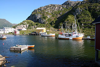
Barkestad is a small fishing village in Øksnes Municipality in Nordland county, Norway. It is located on the southwest side of the island of Dyrøya in the Vesterålen archipelago. The village is located about 5 kilometres (3.1 mi) off the west coast of the main island of Langøya. There are regular ferry stops at Barkestad with connections to other nearby islands and to the municipal centre of Myre, located about 15 kilometres (9.3 mi) to the northeast. There are only four residents of the village after many years of population decline. They are the only permanent residents of the whole island.
Nykvåg is a fishing village in Bø Municipality in Nordland county, Norway. It is one of the largest fishing villages on the west coast of the large island of Langøya in the Vesterålen archipelago. The village lies along the south side of Nykvåg bay and the neighboring village to the west is Vågen. The villages of Hovden and Malnes are located about 5 kilometres (3.1 mi) northeast of Nykvåg. Nykvåg is also known for its rich bird life in the Nykvåg/Nykan Nature Reserve adjacent to the village.
Stø is a fishing village located on the northern tip of the island of Langøya, along the Gavlfjorden in the Vesterålen archipelago. It is part of the municipality of Øksnes in Nordland county, Norway. In 2001, there were about 175 residents. This village was the administrative centre of the old municipality of Langenes which existed from 1919 until 1964.

Dyrøya is a small island in Øksnes Municipality in Nordland county, Norway. It is located off the west coast of the large island of Langøya in the Vesterålen archipelago. The small islands of Nærøya and Tindsøya lie to the west and the island of Skogsøya lies to the north. The 6.5-square-kilometre (2.5 sq mi) island has one village, Barkestad, and there are only 4 residents on this island. There are no road connections to the island, so all residents must use boats. The highest point on the island is the 562-metre (1,844 ft) tall mountain Blåtinden.

Myre Church is a parish church of the Church of Norway in Øksnes Municipality in Nordland county, Norway. It is located in the village of Myre in the northern part of the island of Langøya. It is one of the churches for the Øksnes parish which is part of the Vesterålen prosti (deanery) in the Diocese of Sør-Hålogaland. The white, concrete church was built in a fan-shaped style in 1979 by the architect Arne Aursand. The church seats about 300 people.

County Road 820 is a 73.1-kilometer (45.4 mi) road in the municipalities of Bø, Øksnes, and Sortland in Nordland County, Norway. It starts in the village of Straumsnes in the municipality of Bø, where it continues south from County Road 901, circles around the west end of the island of Langøya through the Straume Nature Reserve to the village of Straume, and continues east to the Ryggedal Tunnel. It then passes through the municipality of Øksnes along the west shore of Ånnfjord and south shore of Skjellfjord before entering the municipality of Sortland. There it passes along the inner shore of Eidsfjord through Frøskeland, crosses Vikeid, where County Road 956 branches off to Vik, and then runs past the southwest shore of the Vikosen Nature Reserve and along the west side of Sortlandssundet strait, where it terminates at the town of Sortland.