
Kaumakani is a census-designated place (CDP) in Kauaʻi County, Hawaiʻi, United States. The population was 749 at the 2010 census, up from 607 at the 2000 census.
The bellstone is a pillar located in Kauai County, Hawaii near 'Opaeka'a Falls. It is so named because, when struck sharply, a note would resonate over a large area of Wailua Valley, warning of danger. Royal births were announced this way. Nearby is a view of 'Opaeka'a Falls.

The Wailuā River is a major river on the island of Kauaʻi in the U.S. state of Hawaii. At 20 miles (32 km) long, it is Kauai's largest and longest river, as well as Hawaii's 3rd longest river. It is formed by the confluence of its North and South forks just west of Wailua and enters the Pacific Ocean at 22°2′42″N159°20′11″W. It is the only navigable river in the Hawaiian Islands. It is a center of activity for locals and visitors in the form of boat tours to Fern Grotto, kayaking and water skiing.

Hāʻena State Park is a state park located on the north shore of the Hawaiian island of Kauaʻi. It is often referred to as the "end of the road" and marks the end point of the Kuhio Highway. The park provides access to beaches, trails, and several ancient Hawaiian sites, including sea caves estimated to be more than 4,000 years old. Archaeological sites associated with the hula, including a heiau (shrine) dedicated to Laka, are located above the park's beaches.

The Hanalei River on the island of Kauaʻi in Hawaii flows north from the eastern slopes of Mount Waiʻaleʻale for 15.7 miles (25.3 km) until it reaches the Pacific Ocean at Hanalei Bay as an estuary. With a long-term mean discharge of 216 cubic feet per second, in terms of water flow it is the second-largest river in the state; although its watershed of 19.1 square miles (49 km2) is only sixth-largest on Kauaʻi, it encompasses areas of the highest recorded rainfall on the planet and plunges precipitously from its headwaters at 3,500 feet (1,100 m) above sea level.

Hanakāpīʻai Beach is a beach in the Hawaiian islands located on Kauai's Nā Pali Coast. The beach is approximately 2 miles (3.2 km) from the start of the Kalalau Trail, a very popular hiking trail which is located at Keʻe Beach. It is also about 2 miles from Hanakapiai Falls. During summer months, Hanakāpīʻai Beach's sandy shore line is clearly visible; during winter months, dangerously powerful waves and high tides wash away the sandy shore line. The beach is remotely located with no road access. The word Hanakāpīʻai literally means "bay sprinkling food" in Hawaiian.
Māhāʻulepū Beach is a beach on the southeast coast of the Hawaiian island of Kauai. It is two miles long and goes from Punahoa point to Paʻoʻo point. The beach is separated into three different parts: Gillin's Beach, Kawailoa Bay, and Hāʻula Beach. Gillin's Beach, the center section, is known for petroglyphs that are carved into the rocks, though they are rarely exposed. Fossils of extinct birds have been found in sand dunes along the shoreline, including the Kauaʻi Stilt-owl, a flightless rail, and three species of goose. Close to the beach is the paleontologically important Makauwahi Cave.
Ha'ula Beach is a beach on the southeast coast of the island of Kauai in the Hawaiian Islands.
Kawai Point is a jutting headland on the south-east coast of the island of Kauai in the Hawaiian Islands.

Makana is a mountain located on northern shore of the island of Kauaʻi, where it rises 1,115 feet (340 m) above Limahuli Valley. Makana is a Hawaiian language term meaning gift or reward. It is often used as a person's name or as part of a name. Limahuli Garden and Preserve preserves the valley below. It was featured in the 1958 film adaptation of the musical South Pacific as Bali Haʻi, a name that is still used to this day.
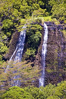
ʻŌpaekaʻa Falls is a waterfall located on the ʻŌpaekaʻa Stream in Wailua River State Park on the eastern side of the Hawaiian island of Kauai. It is a 151–foot waterfall that flows over basalt from volcanic eruptions millions of years ago. Below the ridge down into the ravine through which the water falls can be seen the vertical dikes of basalt that cut through the horizontal Koloa lava flows. The name "ʻŌpaekaʻa" means rolling shrimp, "ʻopae" being Hawaiian for "shrimp," and "kaʻa" for "rolling". The name dates back to days when the native freshwater shrimp Atyoida bisulcata were plentiful in the stream and were seen rolling and tumbling down the falls and into the churning waters at the fall's base.

Langleyville is an unincorporated census-designated place in Christian County, Illinois, United States. It lies at 39°33′44″N89°21′19″W. As of the 2010 census, its population was 432. Langleyville has an area of 0.393 square miles (1.02 km2), all land.
The Waipa Foundation is a non-profit organization which sponsors a program called ʻAina Ulu, funded by Kamehameha Schools.

Kawaikini is the highest point on the Hawaiian Island of Kauai and in Kauai County and measures 5,243 feet (1,598 m) in elevation. It is the summit of the island's inactive central shield volcano, Mount Waialeale. Other peaks on Kauai include: Waialeale, Namolokama Mountain, Kalalau Lookout, Keanapuka Mountain, Haupu and Nounou.

Glass Beach is a beach in Eleele, an industrial area in Kauai, Hawaii that is made of sea glass. It is in Hanapepe Bay, near Port Allen Harbor. The beach's regular rock is basalt, but the sea glass formed after years of discarded glass.

The Royal Coconut Coast is the designation given to Kauai’s east side, defined as the area between the Wailua Golf Course, heading north along the coast to Kealia Beach, and extending inland towards the center of the island, to Mount Waialeale. The Royal Coconut Coast includes the sacred Wailua River area and the large towns of Wailua and Kapaa. The area derives its name from the acres of coconut trees located along the coast and highway. The area also hosts many places of historical and cultural significance, some of the land held as sacred and was once reserved only for the royalty of Hawaii.
Morrisville is an unincorporated community in Clinton County, Ohio, United States.
Big Run is an unincorporated community in Athens County, in the U.S. state of Ohio.
Hāʻena is an unincorporated community and census-designated place on the island of Kauai in Kauai County, Hawaii, United States. Its population was 431 as of the 2010 census. The community is located on the north side of the island along Hawaii Route 560.


