Sleepy Eye Creek

Last updated
Sleepy Eye Creek
Country United States
Physical characteristics
Main source Minnesota

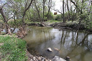
Sleepy Eye Creek is a 51.8-mile-long (83.4 km) [1] tributary of the Cottonwood River of Minnesota, the United States. Via the Cottonwood River, its water flows to the Minnesota River and eventually the Mississippi River.

Cottonwood River (Minnesota) river in Minnesota, United States

The Cottonwood River is a tributary of the Minnesota River, 152 miles (245 km) long, in southwestern Minnesota in the United States. Via the Minnesota River, it is part of the watershed of the Mississippi River, draining an area of 1,313 square miles (3,400 km2) in an agricultural region. The river's name is a translation of the Sioux name for the river, Waraju, for the cottonwood tree, which is common along prairie rivers. It has also been known historically as the Big Cottonwood River.

Minnesota State of the United States of America

Minnesota is a state in the Upper Midwest and northern regions of the United States. Minnesota was admitted as the 32nd U.S. state on May 11, 1858, created from the eastern half of the Minnesota Territory. The state has a large number of lakes, and is known by the slogan the "Land of 10,000 Lakes". Its official motto is L'Étoile du Nord.

Minnesota River river in southern Minnesota over 300 miles long

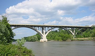
The Minnesota River is a tributary of the Mississippi River, approximately 332 miles (534 km) long, in the U.S. state of Minnesota. It drains a watershed of nearly 17,000 square miles (44,000 km2), 14,751 square miles (38,200 km2) in Minnesota and about 2,000 sq mi (5,200 km2) in South Dakota and Iowa.

Sleepy Eye Creek was named for Chief Sleepy Eye. [2]

Ishtakhaba Santee Dakota chief

Ishtakhaba, also known as Chief Sleepy Eye, was a Native American chief of the Sisseton Dakota tribe. He became chief sometime between 1822 and 1825, receiving a commission from the Bureau of Indian Affairs as chief in 1824, and remained chief until his death in 1860. His band, known as the Swan Lake or Little Rock Band, hunted "in southwestern Minnesota and southeastern Dakota ... between Swan Lake and Coteau des Prairies," until forced to move to reservation land near the Minnesota River in the wake of the 1857 Spirit Lake Massacre.

See also

Related Research Articles

Sleepy Eye, Minnesota City in Minnesota, United States

Sleepy Eye is a city in Brown County, Minnesota, United States. The population was 3,599 at the 2010 census.

San Jacinto River (California)

The San Jacinto River is a 42-mile-long (68 km) river in Riverside County, California. The river's headwaters are in San Bernardino National Forest, but the lower portion of the 765-square-mile (1,980 km2) watershed is urban and agricultural land. As a partially endorheic watershed that is contiguous with other Great Basin watersheds, the western side of the San Jacinto Basin is a portion of the Great Basin Divide.

Plum Creek (Cottonwood River)

Plum Creek is a 35.4-mile-long (57.0 km) stream near the city of Walnut Grove, Minnesota. It passes to the northwest of the town, flowing northeasterly to the Cottonwood River, with its waters then flowing to the Minnesota River and eventually the Mississippi River. Plum Creek lends its name to a regional library network.

Ashley Creek is a 28.3-mile-long (45.5 km) tributary of the Sauk River in central Minnesota, United States, joining the Sauk just north of Sauk Centre. It is part of the Mississippi River watershed.

Battle Creek is a stream in Minnesota. It rises in Battle Creek Lake in Woodbury, passing through residential Maplewood and St. Paul before emptying into the Mississippi River via Pigs Eye Lake. It is followed for much of its length by walking paths.

Buffalo Creek is an 84.3-mile-long (135.7 km) river in central Minnesota. It is a tributary of the South Fork of the Crow River, which is a tributary of the Mississippi River.

Crooked Creek is a 9.9-mile-long (15.9 km) tributary of the Mississippi River in northwestern Minnesota.

Elm Creek is an 89.5-mile-long (144.0 km) tributary of the Blue Earth River in southern Minnesota. It rises in northeastern Jackson County and flows eastwardly through Martin County into northeastern Faribault County, where it joins the Blue Earth River near the city of Winnebago. Via the Blue Earth and Minnesota rivers, it is part of the Mississippi River watershed.

Flandreau Creek is a 41.0-mile-long (66.0 km) river in Minnesota and South Dakota.

Hawk Creek is a 62.0-mile-long (99.8 km) tributary of the Minnesota River in Kandiyohi, Chippewa, and Renville counties, Minnesota, United States. It begins at the outlet of Foot Lake in Willmar and flows southwest, passing the cities of Raymond, Clara City, and Maynard. Turning south, it reaches the Minnesota River 7 miles (11 km) southeast of Granite Falls.

Perch Creek is a 37.3-mile-long (60.0 km) tributary of the Watonwan River in southern Minnesota, United States. Via the Watonwan, Blue Earth, and Minnesota rivers, it is part of the Mississippi River watershed.

Sand Creek is a 36.6-mile-long (58.9 km) tributary of the Minnesota River in Le Sueur and Scott counties, Minnesota, United States. It rises at the outlet of Lake Sanborn, 2 miles (3 km) northeast of the city of Montgomery, and flows north past New Prague, entering the Minnesota River just north of Jordan.

Wells Creek is a 27.6-mile-long (44.4 km) tributary of the Mississippi River in Wabasha and Goodhue counties in Minnesota, United States. It enters the Mississippi at Old Frontenac.

Highwater Creek is a stream in Redwood and Cottonwood counties, in the U.S. state of Minnesota.

Mound Creek is a stream in Brown and Cottonwood counties, in the U.S. state of Minnesota.

Dry Creek is a stream in Redwood and Cottonwood counties, in the U.S. state of Minnesota. It is a tributary of the Cottonwood River.

Sleepy Eye Lake is a lake in Le Sueur County, in the U.S. state of Minnesota.

Sleepy Eye Lake is a lake in Brown County, in the U.S. state of Minnesota.

Elk Creek is a stream in the U.S. state of South Dakota.

References

  1. U.S. Geological Survey. National Hydrography Dataset high-resolution flowline data. The National Map, accessed October 5, 2012
  2. Upham, Warren (1920). Minnesota Geographic Names: Their Origin and Historic Significance. Minnesota Historical Society. p. 72.