Cammell Laird is a British shipbuilding company. The company came about following the merger of Laird, Son & Co. of Birkenhead and Johnson Cammell & Co. of Sheffield at the turn of the twentieth century. The company also built railway rolling stock until 1929, when that side of the business was separated and became part of the Metropolitan-Cammell Carriage and Wagon Company.
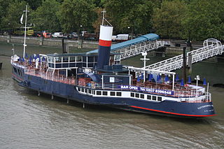
The PS Tattershall Castle is a floating pub and restaurant moored on the River Thames at Victoria Embankment. It served as a passenger ferry across the Humber estuary from 1934 to 1973, before being towed to London in 1976.

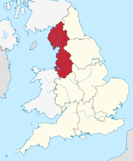
Sheaf Square is a municipal square lying immediately east of the city centre of Sheffield, England.
Schoolhouse Lake Provincial Park, formerly known as Lang Lake Provincial Park, is a provincial park in British Columbia, Canada.

MV Queen of the North was a roll-on/roll-off (RORO) ferry built by AG Weser of Germany and operated by BC Ferries, which ran along a scenic 18-hour route along the British Columbia Coast of Canada between Port Hardy and Prince Rupert, British Columbia, a route also known as the Inside Passage. On March 22, 2006, with 101 people aboard, she failed to make a planned course change, ran aground and sank. Two passengers, whose bodies were never found, died in the incident. The ship had a gross register tonnage of 8,806, and an overall length of 125 metres (410 ft). She had a capacity of 700 passengers and 115 cars.

Flensburger Schiffbau-Gesellschaft is a German shipbuilding company located in Flensburg. The company trades as Flensburger and is commonly abbreviated FSG.

Prather is an unincorporated community in Washington Township, Morgan County, in the U.S. state of Indiana.

Stonecoal Lake Wildlife Management Area is located on 2,985 acres (1,208 ha) in Lewis and Upshur counties, east of Weston, West Virginia, United States. The wildlife management area is centered on Stonecoal Lake (38°59′17″N80°22′41″W), a hydroelectric project owned by Allegheny Energy. The lake was built in 1972 to provide water to Allegheny Energy’s coal-fired power plant in Harrison County.
Kelsey is a rural municipality in the province of Manitoba in Western Canada. It consists of several disjoint parts. The largest part is Carrot Valley, located around and southwest of The Pas along the Carrot River, but the communities of Wanless and Cranberry Portage, located further north, are also part of the municipality. It is 867.64 km² large. Also lying in the area around The Pas is the Opaskwayak Cree Nation Indian reserve.
Morgan Run Natural Environment Area is a protected area in Carroll County, Maryland. Located on 1,930 acres (7.8 km2), Morgan Run features hiking and equestrian trails, catch and release trout fishing, and deer hunting.

Pustki is a village in the administrative district of Gmina Czersk, within Chojnice County, Pomeranian Voivodeship, in northern Poland. It lies approximately 9 kilometres (6 mi) north of Czersk, 35 km (22 mi) north-east of Chojnice, and 69 km (43 mi) south-west of the regional capital Gdańsk.
Lipniak is a village in the administrative district of Gmina Rozogi, within Szczytno County, Warmian-Masurian Voivodeship, in northern Poland.
Eldon Knolls is an unincorporated community in Pittsylvania County, in the U.S. state of Virginia.
The Hudson Project is a 345 kV AC powerline for the power supply of New York City from PSEG's Bergen Generating Station, in Ridgefield, New Jersey.
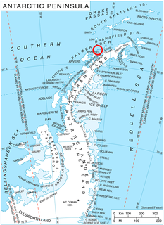
Shterna Glacier is the glacier extending 3.6 km in east-west direction and 2.2 km in north-south direction on Liège Island in the Palmer Archipelago, Antarctica. It is situated northeast of Sigmen Glacier, draining the north slopes of Brugmann Mountains and flowing northwards into Boisguehenneuc Bay.
Cuba is an unincorporated community in the northwestern part of Montgomery Township, Owen County, in the U.S. state of Indiana. It lies near the intersection of County Road 150 West and County Road 600 North, which is a community about ten miles north of the town of Spencer, the county seat of Owen County. Its elevation is 722 feet, and it is located at 39°22′41″N86°47′53″W.
Sundown Manor is an unincorporated community in Brown Township, Morgan County, in the U.S. state of Indiana.
Marineland Gardens is an unincorporated community in Turkey Creek Township, Kosciusko County, in the U.S. state of Indiana.
Redmon Park is an unincorporated community in Van Buren Township, Kosciusko County, in the U.S. state of Indiana.