Sluis 0

Last updated
Sluis 0
Sluis 0 the lock chamber.jpg
Lock chamber of Sluis 0 in 's-Hertogenbosch
Sluis 0
51°41′19″N5°18′57″E / 51.688488°N 5.315841°E / 51.688488; 5.315841
Waterway Zuid-Willemsvaart
CountryNetherlands
County North Brabant
First built1826
Latest built2021 (planned)
Length124.2 m

Sluis 0 is a lock in the Zuid-Willemsvaart, in 's-Hertogenbosch, Netherlands. It is a large lock that will be made much smaller in the 2020s.

Contents

History

Name

The name Sluis 0, or 'Lock Zero', has given rise to many misunderstandings. When construction of the Zuid-Willemsvaart started in 1822, it was to have 19 locks. In 's-Hertogenbosch there was to be a keersluis, or flood lock, where the canal crossed the eastern walls of the fortifications. This flood lock consisted of two flood gates, one in the city walls, and one over a hundred meters backwards at Hinthamer Bridge. Their purpose was to guarantee the inundations around the city in times of emergency, and therefore they were normally open. [1] Because of this different purpose, Sluis 0 was not numbered as one of the locks of the Zuid-Willemsvaart. [2]

Becomes a lock

Sluis 0, the narrow passage in 2020 Sluis 0 in 's-Hertogenbosch, the narrow passage.jpg
Sluis 0, the narrow passage in 2020

It was possible for Sluis 0 to lift ships, even though its length of 124 m made this more tedious. As intended, Sluis 0 operated as a lock when the water outside the city was high. It also operated when the Dieze was low. That skippers started to use the lock as a place for loading and unloading [1] had probably not been expected.

When the Dieze got a lock at Fort Crèvecoeur in 1859, it became necessary to use Sluis 0 as a lock, and at about that time it got its name 'Sluis 0'. The difference in water level between Lock 1 and Crèvecoeur, in theory amounted to only 40 cm. [3]

Widened in the 1930s

In time the small difference in water level between Lock 1 and Crèvecoeur fostered ideas that perhaps one of either Sluis 0 or Lock 1 could be demolished. The choice was made to demolish Lock 1. Sluis 0 had to be renovated to stop a water level that would become 2 meters higher. Sluis 0 was renovated in 1932/33. The walls were made vertical, and the chamber was widened to 26.5 m. During the operation about 35 meters of heavy, and 57 meters of lighter medieval brick walls were found, and removed. Part of this was probably the quay of the River Aa where it entered the city to join the Binnendieze as Doode Stroom. [3]

Situation 2014-2020

Sluis 0 from the east in 2020 Sluis 0 from the east.jpg
Sluis 0 from the east in 2020

During 2014, the last year of operation for commercial shipping, Sluis 0 was 124,2 m long, had a chamber of 116,5 m long and was 26,4 m wide. The width at the doors was 6,8 m. Maximum size of ships that could use the lock was 90.0 m long, 6.7 m wide, and 2.1 m deep. [4]

The Zuid-Willemsvaart continued to be a significant waterway in the twentieth century. However, as ships became ever larger, the passage through 's-Hertogenbosch became increasingly problematic. The canal had been designed for ships of a maximum draught of somewhat less than 2 m. Over time, it had been upgraded to CEMT-Class II. The Dutch government then wanted to upgrade it further to CEMT-Class IV, but this would have incurred high cost. It would also not address the congestion problems caused by the combination of dramatically increased road traffic and regularly opened bridges in the city center. Therefore, the Máxima Canal was dug just east of Sluis 0. In enabled ships of CEMT-Class IV to reach the Meuse without sailing through the center of 's-Hertogenbosch.

After the opening of the Máxima Canal in December 2014 it became quite on Sluis 0. Commercial navigation was forbidden, and the opening of the bridges and Sluis 0 in 's-Hertogenbosch city was severely limited. Recreational traffic then also fell. It went from 1944 boats in 2014 to about 300 a year thereafter. [5]

Plans in 2020

By 2020 many plans had been made for Sluis 0. The Waterschappen wanted a higher water drainage capacity at peak times, but lower water use in the dry season. The municipality wanted more recreational craft to sail through 's-Hertogenbosch. Meanwhile, the lock itself was end of life. Therefore, a plan was made for a smaller lock that could be operated faster, allowing higher recreational use. Instead of using 9,000 m3 of water, the new tighter and shorter lock chamber would use only 450 m3 at each use. On each side of the new lock, very large drainage pipes were planned. When needed these would allow increased drainage through the city center, instead of along the river Aa. On top of the tightened sides of the lock chamber, a park, the Zuid-Willemspark would be realized. [6]

Notes

  1. 1 2 Steketee 1997, p. 101.
  2. Molhuysen 1997.
  3. 1 2 Steketee 1997, p. 102.
  4. Rijkswaterstaat 2020, p. 166.
  5. Brink, Marc (8 August 2018). "Den Bosch populair bij pleziervaart ondanks beperkt schutten Sluis 0". Brabants Dagblad.
  6. Municipality 's-Hertogenbosch 2019.

Related Research Articles

<span class="mw-page-title-main">'s-Hertogenbosch</span> City in North Brabant, Netherlands

's-Hertogenbosch, French: Bois-le-Duc, ; German: Herzogenbusch, colloquially known as Den Bosch, is a city and municipality in the Netherlands with a population of 157,486. It is the capital of the province of North Brabant and its fourth largest by population. The city is south of the Maas river and near the Waal.

<span class="mw-page-title-main">Zuid-Willemsvaart</span> Canal in the Netherlands

The Zuid-Willemsvaart is a canal in the south of the Netherlands and the east of Belgium.

<span class="mw-page-title-main">Nederweert</span> Municipality in Limburg, Netherlands

Nederweert is a municipality and a town in southeastern Netherlands with a population of 17,171 as of 2021 and has an area of 101.78 km2 (39.30 sq mi) of which 1.80 km2 (0.69 sq mi) is water.

<span class="mw-page-title-main">Someren</span> Town and municipality in North Brabant, Netherlands

Someren is a municipality and town in the province of North Brabant in the Southern Netherlands. As of January 2019, the municipality had 19,322 inhabitants, with over half of the population residing in the town. Someren, just south of Helmond and to the north of Weert, Limburg, is located on the provincial border with Limburg.

<span class="mw-page-title-main">Aa (Meuse)</span> River in Netherlands

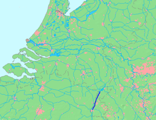
The Aa is a small river in the Netherlands. It rises near Nederweert in the southeastern province of Limburg, in the Peel region. It flows northwest through the province of North Brabant towards 's-Hertogenbosch, roughly along the Zuid-Willemsvaart canal. In 's-Hertogenbosch, at the confluence of the Aa and the Dommel, the river Dieze is formed, which flows into the Meuse a few km further. The main cities and towns along the Aa's course are Asten, Helmond, Veghel and 's-Hertogenbosch.

<span class="mw-page-title-main">Juliana Canal</span> 36 km long canal in the southern Netherlands

The Juliana Canal, named after Queen Juliana of the Netherlands, is a 36 km long canal in the southern Netherlands, providing a bypass of an unnavigable section of the river Meuse between Maastricht and Maasbracht. It is an important transport connection between the ports of the Rhine delta and the industrial areas of southern Limburg and southern Belgium.

<span class="mw-page-title-main">Dieze</span> River in the Netherlands

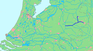
The Dieze is a short river in North Brabant, the Netherlands, tributary of the Meuse. It is formed by the confluence of the rivers Aa and Dommel in 's-Hertogenbosch. The part of the Dieze in the centre of 's-Hertogenbosch is called Binnendieze, a partly covered network of canals. The Dieze flows into the Meuse near Hedel.

<span class="mw-page-title-main">Binnendieze</span> River in Netherlands

Binnendieze is the common name for the river and canal system within the city walls of 's-Hertogenbosch, the Netherlands. It is a tourist attraction. Near the north-west tip of the city walls, the confluence of the Binnendieze with the rivers Aa and Dommel forms the short river Dieze, tributary of the Meuse.

<span class="mw-page-title-main">Twentekanaal</span>

The Twentekanaal is a canal running through the Dutch provinces of Gelderland and Overijssel, connecting the three largest cities of the Twente region, Almelo, Hengelo and Enschede to the national network of rivers and canals. Because the canal forks to reach Almelo, the canal is officially plural, which is Twentekanalen.

<span class="mw-page-title-main">Voorne Canal</span> First canal to connect Rotterdam, in the Netherlands, to the sea

The Voorne Canal is a former ship canal on Voorne-Putten in South Holland, the Netherlands. It was the first canal to connect Rotterdam to the sea. Construction of the canal started in 1826 and was completed in 1829. Until the completion of the Nieuwe Waterweg in 1872 it was the main connection from Rotterdam to the sea for ocean going ships.

<span class="mw-page-title-main">Citadel of 's-Hertogenbosch</span> Fortress in the Netherlands

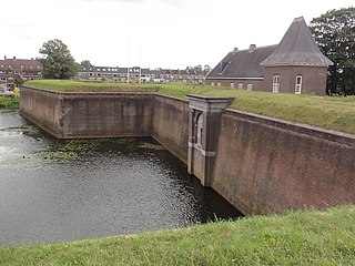
The Citadel of 's-Hertogenbosch is a fortress on the north side of the town center of 's Hertogenbosch in the Netherlands. It was constructed from 1637 to 1642.

<span class="mw-page-title-main">Fort Crèvecoeur (Netherlands)</span>

Fort Crèvecoeur was a Dutch fortress near 's-Hertogenbosch. It is now used as a military exercise terrain.

<span class="mw-page-title-main">Máxima Canal</span>

The Máxima Canal dates from 2014 and runs from the Zuid-Willemsvaart near Den Dungen to the Meuse near Gewande.

<span class="mw-page-title-main">Drongelens Canal</span> Drainage canal in the Netherlands

The Drongelens Canal is a drainage canal that runs from 's-Hertogenbosch to Drongelen in North Brabant. The colloquial Dutch name, and the name used on street signs is Drongelens Kanaal. The official Dutch name is Afwateringskanaal van 's-Hertogenbosch naar Drongelen.

<span class="mw-page-title-main">Dieze Bridge</span> Bridge in s-Hertogenbosch, Netherlands

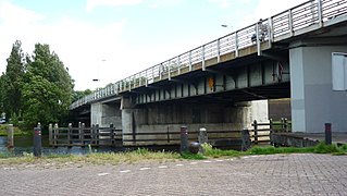
The Dieze Bridge is a bridge for road traffic. It spans the rivers Dieze and Aa, just north of 's-Hertogenbosch, Netherlands. The Dieze Railway bridge is somewhat further downstream.

<span class="mw-page-title-main">Koopvaarders Lock</span>

Koopvaarders Lock in Den Helder, Netherlands connects the Noordhollandsch Kanaal to the Nieuwediep. There were 4 locks at Nieuwediep carrying this name.

<span class="mw-page-title-main">Engelen Lock</span>

Engelen Lock is a lock with vertical-lift bridge in the Dieze Canal near Engelen, North Brabant, just before the canal exits into the Meuse.

<span class="mw-page-title-main">Wilhelmina Canal</span>

The Wilhelmina Canal is a canal in North-Brabant, Netherlands. It connects Tilburg to the Meuse, and continues to the east to connect to the Zuid-Willemsvaart north of Helmond.

<span class="mw-page-title-main">Wessem-Nederweert Canal</span>

Wessem-Nederweert Canal is a canal connecting the Zuid-Willemsvaart at Nederweert to the Meuse near Wessem. Here it meets the wide Juliana Canal that connects to Maastricht.

PS Jan van Arkel II was a Dutch passengers paddle steamer of the Gorinchemsche Schiedamsche Stoomboot-maatschappij built by Fop Smit and launched on 8 March 1847. The ship was used for the 's-Hertogenbosch—Gorinchem—Schiedam line.

References