
The Rouge River is a river in Markham, Pickering, Richmond Hill and Toronto in the Greater Toronto Area of Ontario, Canada. The river flows from the Oak Ridges Moraine to Lake Ontario at the eastern border of Toronto, and is the location of Rouge Park, the only national park in Canada within a municipality. At its southern end, the Rouge River is the boundary between Toronto and southwestern Pickering in the Regional Municipality of Durham.

The Scarborough Bluffs, also known as The Bluffs, is an escarpment in the Scarborough district of Toronto, Ontario, Canada. There are nine parks along the bluffs, with Bluffers Park being the only one with a beach. Forming much of the eastern portion of Toronto's waterfront, the Scarborough Bluffs stands above the shoreline of Lake Ontario. At its highest point, the escarpment rises 90 metres (300 ft) above the coastline and spans a length of 15 kilometres (9.3 mi).

Sunnyside is a lakefront district in Toronto, Ontario, Canada. It includes a beach and park area along Lake Ontario's Humber Bay, from west of Exhibition Place to the mouth of the Humber River. The area has several recreation uses, including rowing clubs, sports clubs, picnic areas, playgrounds, a nightclub, a bathing pavilion and public pool. The area is a 3 kilometres (1.9 mi) long strip along the lakeshore, bounded by the Gardiner Expressway and rail lines, which separate it from the Parkdale, Roncesvalles and Swansea neighbourhoods to the north. The name originates in a local farm owned by John Howard, which was situated just to the north, on the location of the current St. Joseph's Health Centre hospital.
The Toronto and Region Conservation Authority (TRCA) is a conservation authority in southern Ontario, Canada. It owns about 16,000 hectares of land in the Toronto region, and it employs more than 400 full-time employees and coordinates more than 3,000 volunteers each year. TRCA's area of jurisdiction is watershed-based and includes 3,467 square kilometers – 2,506 on land and 961 water-based in Lake Ontario. This area comprises nine watersheds from west to east – Etobicoke Creek, Mimico Creek, Humber River, Don River, Highland Creek, Petticoat Creek, Rouge River, Duffins Creek and Carruthers Creek.

Kew Gardens is a large park in The Beaches neighbourhood of Toronto, Ontario, Canada. The park stretches from Queen Street East to Lake Ontario at Kew Beach.

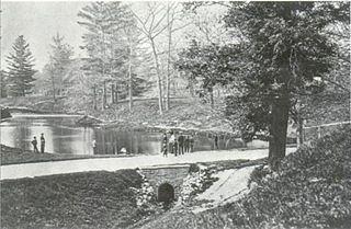
Highland Creek is a river in the Scarborough district of Toronto, Ontario, emptying into Lake Ontario at the eastern end of the Scarborough Bluffs. It is home to several species of fish including trout, carp, bass and salmon. It is a meandering river which, like most rivers in Toronto, travels through a glacial ravine formed after the last Ice Age. The Highland Creek watershed, including tributaries, is almost entirely contained within Scarborough.

Highland Creek is a neighbourhood in eastern Toronto, Ontario, Canada. It is located along the southern portion of the river of the same name in the former suburb of Scarborough. To the east are the neighbourhoods of Port Union and West Rouge, to the west West Hill and Woburn, and to the south Centennial Scarborough.
Waupoos Island is a community in Ontario, located within the municipality of Prince Edward County in the northwest quadrant of Prince Edward Bay. A private ferry service across Smith Bay from the hamlet of Waupoos on the mainland is operated by a holiday camp on Waupoos Island. The island is a favored anchorage for experienced sailors familiar with the rocky shoals in the area.

Superior Creek was a stream draining into Lake Ontario in the former village of Mimico, Ontario, Canada. It was approximately 3 kilometers long, with headwaters near the present intersection of Kipling Avenue and The Queensway. The lower reaches of the creek had become polluted, and were buried in a sewer in 1915. In 1954, citizens of Mimico living in newly built houses near the upper reaches complained that the creek flooded, and lobbied to have the creek replaced by storm sewers, and a study was prepared. According to HTO: Toronto's water from Lake Iroquois to lost rivers to low-flow toilets, the creek was buried around 1965.
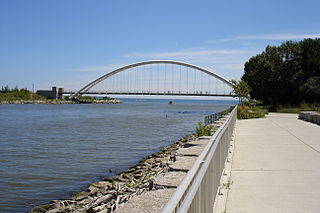
The Martin Goodman Trail is a 56 km (35 mi) multi-use path along the waterfront in Toronto, Ontario, Canada. It traverses the entire lake shore from one end of the city to the other, from Humber Bay Arch Bridge in the west to the Rouge River in the east. The Martin Goodman Trail is part of the 730 km Waterfront Trail around Lake Ontario.
Marie Curtis Park is a public park in Toronto, Ontario, Canada. It is located at the mouth of the Etobicoke Creek on Lake Ontario in the Long Branch neighbourhood. Marie Curtis Park was built after the devastating floods of Hurricane Hazel in 1954 destroyed 56 homes and cottages on the site, leaving 1,868 persons homeless and 81 dead. It is named after Marie Curtis, the reeve of Long Branch at the time of its construction. Long Branch at the time was a separate village; it's now amalgamated into the City of Toronto government.

Ashbridges Bay is a bay and park in Toronto, Ontario, Canada. It is located along Lake Shore Boulevard next to Woodbine Beach in the Beaches. The Martin Goodman Trail and boardwalk run through the park along the bay. The boardwalk runs 3 kilometres (1.9 mi) from Ashbridges Bay in the west to the R. C. Harris Water Treatment Plant in the east along Lake Ontario. It was once part of the marsh that lay east of Toronto Islands and Toronto Harbour.

The Osterhout Log Cabin is a log cabin located within Guild Park and Gardens, Guildwood, Scarborough, Toronto, Ontario, Canada. Situated along the Scarborough Bluffs, the cabin is one of the oldest remaining buildings in Scarborough, Toronto.
Ashbridge's Creek was a watercourse that flowed in Ashbridge's Bay, between the Don River and Highland Creek. Its headwaters were north of Greenwood and Danforth avenues, making it about 4 kilometres (2.5 mi) long.
Small's Creek was one of the three watercourses that flowed into Small's Pond, a small body of water of several acres in area, located near the intersection of Queen Street and Kingston Road, in Toronto, Ontario. There is a small plain between the shore of Lake Ontario and the bluffs which marked the shore of the larger Glacial Lake Iroquois, Bedrock was shallow on the plain. Smalls Creek, Tomlin's Creek, the other watercourse that drains into Smalls Pond, and Ashbridge's Creek to the east were all small, short watercourses, with their headwaters on that small plain, had each become polluted by the turn of the 20th century, when the regions they flowed through were annexed into the growing city of Toronto.

Charles Coxwell Small was a wealthy farmer and public official in Upper Canada. Like his father, John Small, Small was the Chief Clerk of Upper Canada's Privy Council.

Tomlin's Creek is short creek in Toronto, which drained into Small's Pond. Its headwaters seem to have been in the ravine that contains Glen Davis Crescent, because residents report small springs breaking out.
McCaul's Pond was located at the site of Hart House, on the University of Toronto campus. It was created by damming Taddle Creek in the early 1860s. Increased settlement and economic activity had already begun changing the creek from being the clear, free running watercourse that the early settlers had found. It had been so clean that it was a breeding ground for salmon, but over time had become a polluted watercourse. Damming the creek accelerated the dangers and the pond was drained prior to burying the University's portion of the creek in 1884.

Yellow Creek is a partially-buried southeasterly tributary of the Don River in Toronto. It has also been known at different times as Silver Creek, Sylvan Creek, and Rosedale Brook. The former source of Yellow Creek begins near Sheppard West station in the Downsview neighbourhood. Most of the creek and its sources are buried underground in storm sewers until they emerge into Avoca Ravine in the Deer Park neighbourhood and continue their way to the Don River.
Wendigo Creek was a short watercourse in Toronto, Ontario, that drained into Grenadier Pond. It was spring fed, like nearby Spring Creek. Its headwaters were north of Bloor Street, near Dundas Street and Laws Street.
